

By Glenn Burns
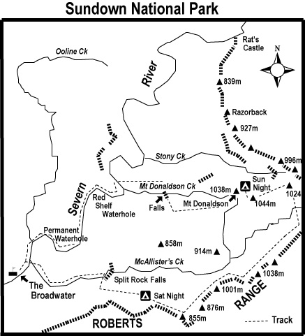
The following account is of a three day bushwalking circuit that I did with two friends in southern Sundown National Park in which we followed up McAllisters Ck, a deeply incised tributary of the Severn River. From McAllisters we ascended onto the Roberts Range at about 900 metres. After a long hot walk along the high Roberts Range we turned westwards pushing through dense undergrowth to overnight on Mt Donaldson at 1038 metres. The following day we descended back into the Severn River.
In early October, walking friends Frank , Don and I completed a three day bushwalking circuit in Sundown National Park taking in some very interesting and challenging landscapes on the way. Although only thirty kilometres from Girraween as the crow flies, Sundown has little in common with the benign rounded tor landscapes of the Stanthorpe Granites.
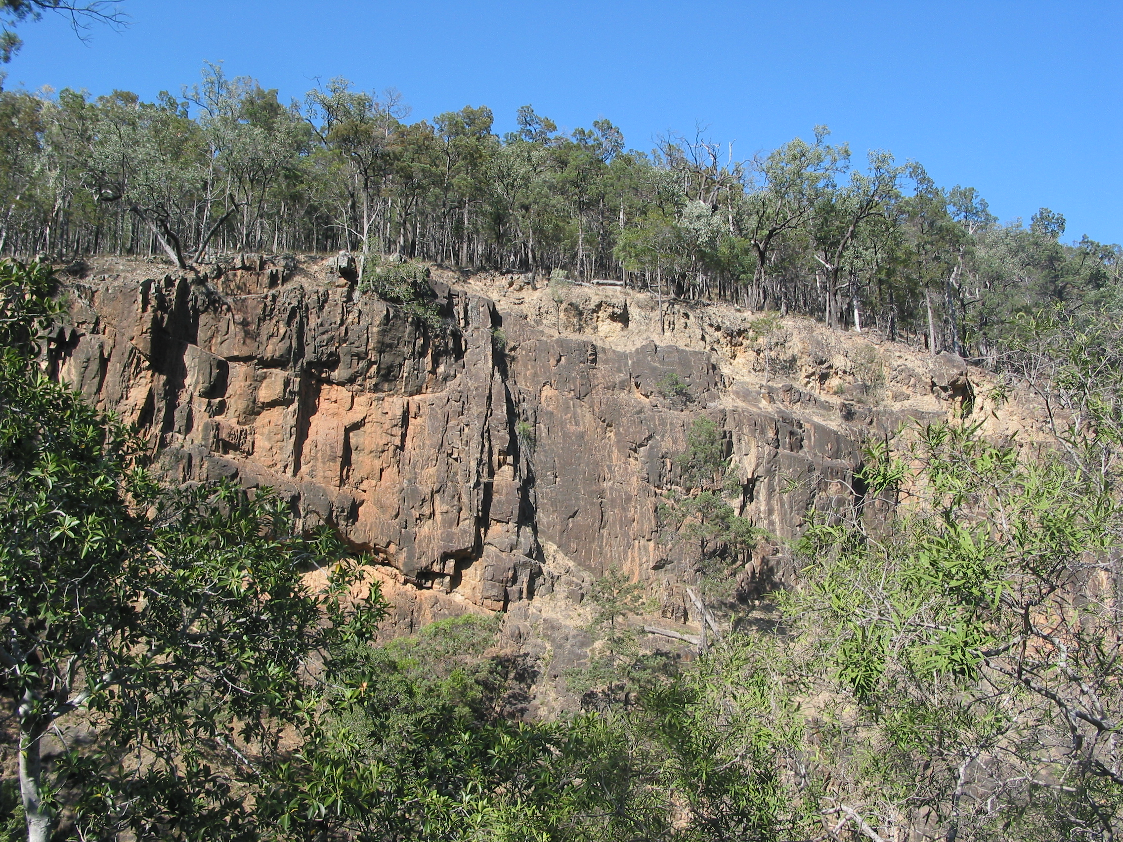
Sundown offers a terrain of deeply incised creeks, gorges, waterfalls and steep stony ridges rising to 1000 metres. It is an inhospitable environment, dry and rocky. To me, a landscape reminiscent of the MacDonnell Ranges of Central Australia. Early settlers described it as “traprock”, geologically incorrect but an apt descriptor all the same. Traprock is a term applied to basalt landscapes in the UK while Sundown’s surface geology is predominately sedimentary which has been altered by heat and pressure (termed: metasedimentary).
Photo Gallery

Our trip followed an anticlockwise circuit: from the Broadwater up the gorge-like McAllister’s Creek, to Split Rock Falls; a climb to the Roberts Range at 800 to 1000 metres; a major scrub bash to Mt Donaldson (1038 metres); a steep descent to Mount Donaldson Creek and the spectacular Donaldson Creek Falls and a return down the boulder choked Severn River to the Broadwater Campground.
Geology of Sundown National Park
Sundown’s stony terrain had its origins in the Carboniferous Period (360million – 286 million years ago). Sediments from a volcanic mountain chain on the eastern edge of the Gondwana continent were deposited on the continental shelf and later avalanched onto the deep ocean floor.
The sediments formed thick beds of sands, silts and mud. Compression and deformation of the beds resulted in the metasediments of the Texas Beds. The predominate rock types of the Texas Beds are Argillite and Greywacke. Argillite is a dark grey/black mudstone, very fine grained and extremely hard. Greywacke is a coarse grained sedimentary of mixed composition, also very hard. These were later uplifted to a mountain chain, the remnants of which form the tilted hilly ridges of Sundown.
DAY ONE
McAllister Creek Gorge
We left Broadwater mid afternoon and rock hopped up McAllister Creek to Split Rock Falls. Here the creek was deeply entrenched in a narrow red gorge, defying Frank’s GPS to find the requisite number of satellites.
Following Don’s confident lead we hung from cracks and crevices, teetered along dubious ledges, finally reaching the barely trickling “split” falls, impassable…. of course.
Our bypass was a steep scrabbly climb on the spine of a rocky ridge to our campsite in a cypress pine grove at 800 metres. One of the very few open areas in an otherwise very stony terrain.
At 6.30pm, on sunset, we downed packs and settled into our campsite, complete with its own comfortable log seats and frug of whining mosquitoes. I soon lost my desire to join the “sleep under the stars” contingent as a full moon rose and the mosquitoes settled in for the duration. Instead I retired in comfort to my insect/moonlight proof “Taj Mahal”.

DAY TWO
Roberts Range
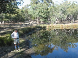
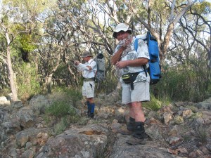
Our traverse along the crest of Roberts Range on the second day followed one of the ancient ridges. The Roberts Range was a roller coaster of elevation gains followed by steep descents. Hot work. Incredibly, we found two small dams high up in the catchment where we could replenish our water supplies and wash. Mid afternoon we swung off the Roberts Range heading for Donaldson.

Mt Donaldson
Progress faltered to about one kilometre an hour and visibility fell to ten metres as we pushed through unpleasantly dense thickets of Peach Bush (Ehretia membranifolia) and Cough Bush (Cassinia laevis). On occasion, one of our trio would disappear into a thicket failing to re-emerge after an appropriate wait. Several cooees usually provided the necessary geographic re-orientation and a bleeding bruised body would come flailing through the undergrowth, in due course.

On the summit of Mt Donaldson on our second evening we found some younger Permian breccias on top of the Texas beds. Breccias are sedimentaries composed of coarse, angular fragments of older rocks. My guide book implied fossil shellfish aplenty these outcrops. Even Blind Freddy should find one. The breccias were obvious enough but the fossils weren’t. Unfortunately, my conscience wouldn’t allow me to shatter rocks to find them, tempting though the prospect was.
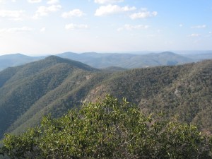
As the sun set we perched on rocky benches above the cliffline and took in the view. This is reputed to be the best vantage point in the park, not an exaggerated claim. A rugged landscape unfolded: Donaldson’s northern summit was fringed by massive cliffs; stretching off to the north east was the Razorback (Berchtesgaden on my map) a ridgeline of numerous 900 and 800 metre hills grading down to the Rats Castle (a granitic dyke) on the Severn River, four kilometres away. Immediately below was the Stony Creek valley, lined with numerous scree slopes of shattered boulders. My track notes advised that walkers should not be
“tempted to descend Stony Creek since it is strewn with large boulders.”
On a distant western cliffline a trip of goats skittered along a narrow ledge, intent on finding a night bivouac in the thick brush.
DAY THREE
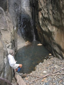
With the Stony Creek warning in mind, we left Mount Donaldson at 5.30am, chased off the summit by gale force winds and a suspiciously thick cloud bank building to our east over Stanthorpe. We descended steeply into Mount Donaldson Creek. Here we rewatered, dropped packs and headed downstream to inspect Donaldson Creek Falls, developed on resistant strata, with its 100m drop towards the Severn River.
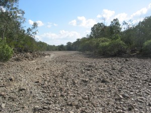
The views down a red canyon to the Severn did not disappoint. Saddling up again we bypassed the falls and descended 230 vertical metres to the Severn River Flood Plain. The bed of the Severn is confined to the NNE trending Severn River Fracture Zone.
It is interesting that the river has not diverted around the harder Texas Beds but has continued to cut down into the resistant metasediments. Consequently, for such an old land surface the sinuosity of meander looping of the Severn is remarkably undeveloped. The sinuosity ratio for the Severn in Sundown is 1.04; very close to the ratio for straight, younger streams such as the Johnstone River (North Queensland) which has a ratio of 1.00.
A stream channel on a flat flood plain will often have a ratio of 3.00 or more (technically described as tortuous). Still, this was all useless palaver as we hoofed the final six long hot steamy kilometres along a rough, bouldery river bed to our final destination at Broadwater.
My thanks to Frank and Don for their invitation to join them on the Sundown trip and for some great navigation and geology.
References:
Willmott, W, 2004: Rocks and Landscapes of the National Parks of Southern Queensland.
Mapsheets:
Sundown National Park 1:50,000 ( Hema Maps)
Mount Donaldson 1:25,000
Mingoola 1:25,000
