By Glenn Burns
With the Easter long weekend closing in, I wasn’t surprised when my bushwalking friend Brian appeared at the front door clutching one of his well-used topo maps and muttering about “getting away from the crowds over Easter.”
Here’s a thing about Brian. He’s a map-man of the old school. There’s nothing much he likes better than to spread out a map, trace a finger along ridge and river and, hey presto a walk is born. Strangely though, I have rarely seen him brandishing a compass and never a GPS.
Photo Gallery


As more and more wilderness areas fall to incursions of the Great Walk track builders, ‘tell-all’ guidebooks and those viral GPS track logs, it is becoming increasingly difficult to find a throughwalk that still has some tantalising unknowns.
But I can always rely on Brian to trawl through his map cupboard and come up with something decent; in this case an “exploratory” into northern Sundown National Park, south-west of Stanthorpe.
Some say that the name Sundown is said to come from the idea that its valleys are so deep that it’s always ‘Sundown’. Others claim that the name is in keeping with the tradition of using astronomical place names in the area, but I couldn’t find much evidence for this interpretation, apart from references to Comet Creek, Comet Mine, and Arcturus Mine.

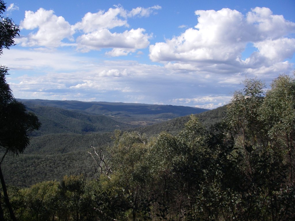
Sundown offers a terrain of deeply incised creeks, gorges, waterfalls and steep stony ridges rising to over 1000 metres on the Roberts Range. As well, it has an interesting cultural heritage of aboriginal occupation, pastoralism and later on, mining.
Brian had nutted out a 54 kilometre walk that had some navigational problems and, not unexpectedly, there was the obligatory physical challenge. It would also give us some respite from camping near raucous Easter 4WDers and was remote enough to be off the radar for most of the latter-day bushwalking fraternity.
Although only thirty kilometres from the well known Girraween National Park as the crow flies, the 12910 hectare Sundown National Park has little in common with the benign rounded tor landscapes of the Stanthorpe Granites.
Early settlers described Sundown’s rugged and rocky terrain as “traprock”, geologically incorrect, but a good descriptor all the same. Traprock is a term originally applied to basalt landscapes in the UK, while Sundown’s lithology is predominately sedimentary which has been partially altered by heat and pressure to form metasediments. These are called the Texas Beds and are of early Carboniferous origin.
What it does share with Girraween is its propensity for cold weather. This is Queensland’s coldest district; eight months have temperatures below 0° C, with -10.6 C° the lowest. Fortunately the average minimum for April is a comfortable 9.5 C°.
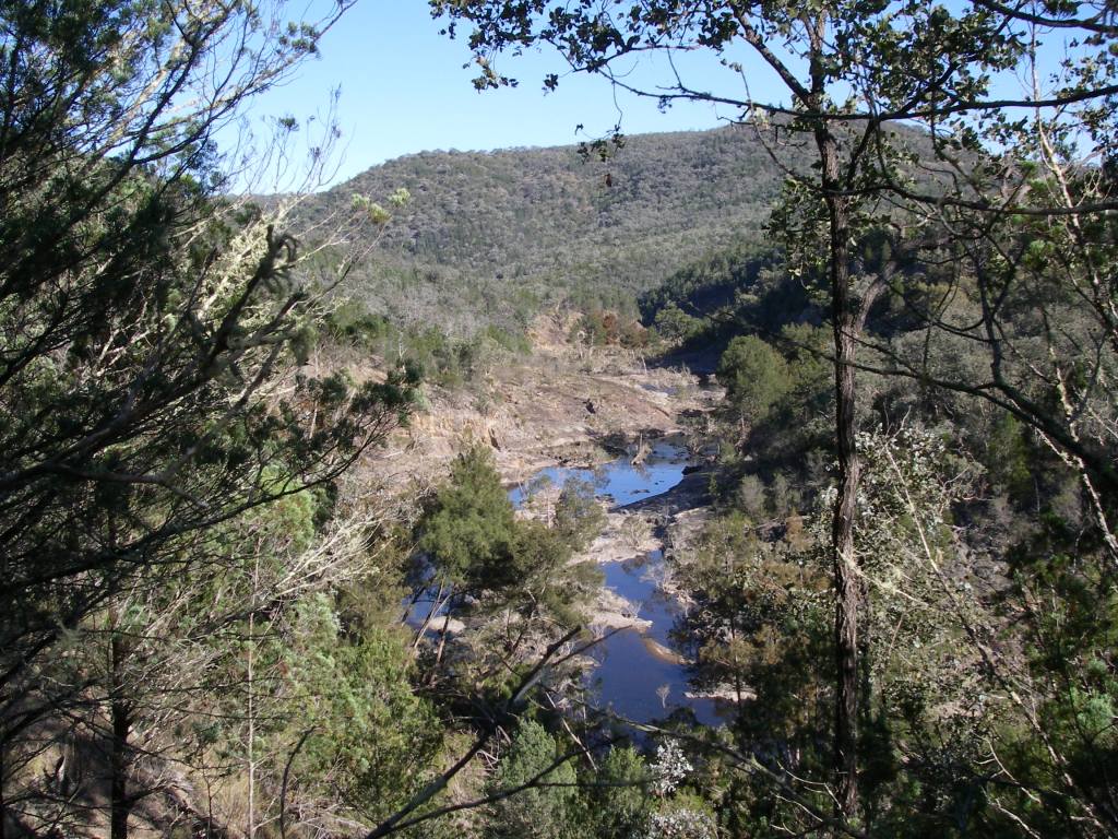
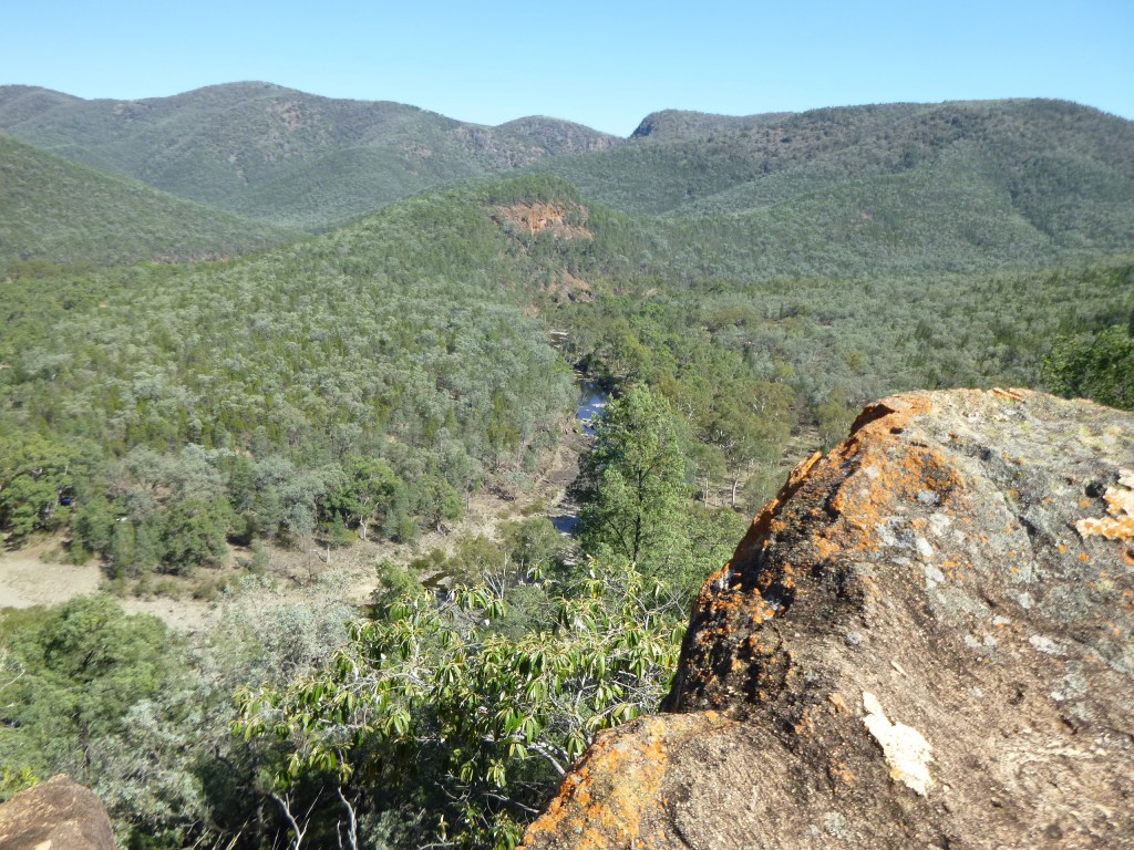
The Severn River, named after the Severn River in England, has incised deeply into the traprock and its course is lined with numerous deep permanent waterholes, many bordered by vertical red clifflines. No danger of going thirsty here even though the park lies predominately on the western side of The Great Dividing Range. In fact, at the end of the wettest Queensland summer in 40 years the park ranger reported to Brian that the Severn was still in moderate spate and we could expect piles of flood debris.

Friday : Sundown Homestead site to Severn River via Mt Lofty: 10 kms.
My fellow walkers assembled at the old Sundown Homestead site soon after 1.00 pm, in warm humid conditions.
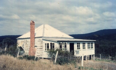
Peter Haselgrove, The Ranger- in – Charge of Sundown NP for many years remembers the homestead as well as a large weatherboard hay shed ( removed ) uphill from the homestead. The shearers’ quarters were further to the south of the homestead, also no longer there.
Our party was eight in total: Brian (leader), Malcolm and Jenny, Bernard (an uber-fit septuagenarian), Russell (aka Starkie) Leanda, and my fellow ailurophile, Richard. Our immediate task was to sweat up the 260m, three kilometre climb to Mt Lofty, a long whaleback feature topping out at 1067 metres.
Mt Lofty is said to have been named thus as it was the highest point on the road leading to the Sundown Mine, hence it was “Lofty”. Naturally the Law of Diminishing Returns always applies and our efforts ended in an obscure and thickly vegetated summit. View factor: pretty average, though a vast improvement on Brian’s infamous Kerries whiteout . But this didn’t stop Brian bagging it as one of his 1000 metre peaks, celebrating its capture with a wee dram of someone’s hootch.
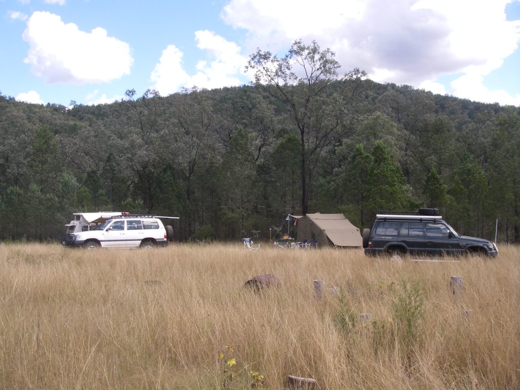
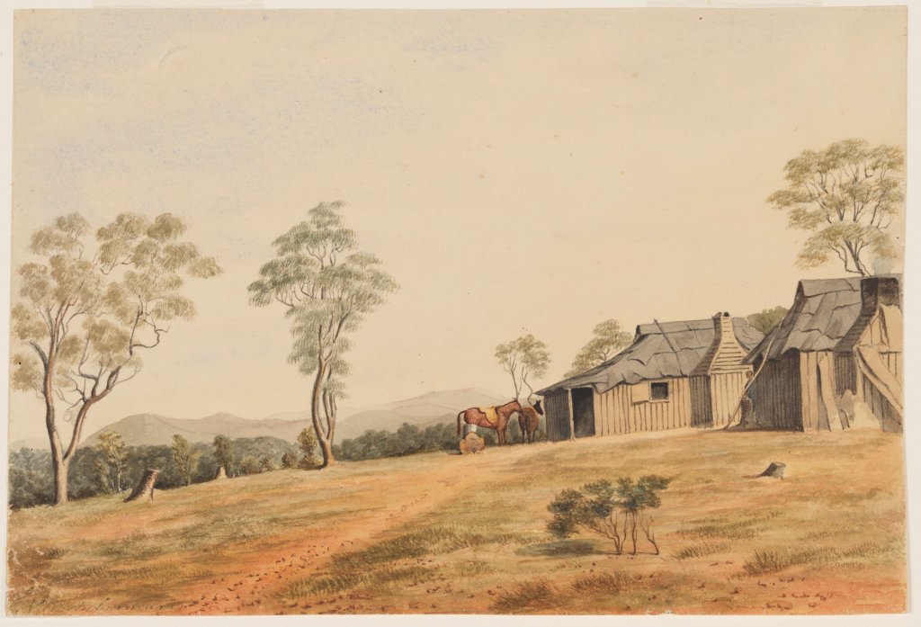
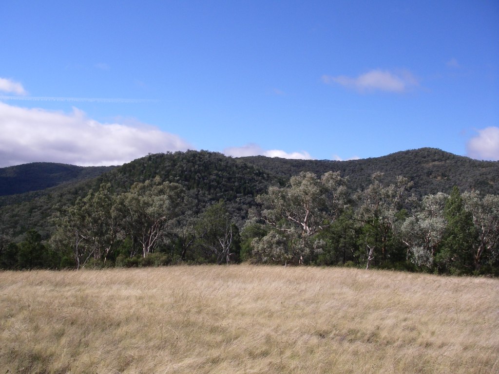
Then came the descent to the Severn River; a long, roller-coasting two kilometre fire trail that rode up and down over a series of hillocks, ever decreasing in height down to the river at 600m. In fading light a meandering 4WD track carted us off towards our picturesque overnight campsite at Lowe’s Waterhole: an open grassy clearing complete with its own melancholic collection of decrepit yards, a tottering corrugated iron shack and ancient barbed wire fencing.
Lowe’s Waterhole was named for a local selector but it is also called Koinas Tanks, which doesn’t always appear on maps. Koina was a Stanthorpe plumber.

These were relicts of bygone times when Sundown was a pastoral run. It was part of the much larger Mingoola, Nundubbermere and Ballandean Stations, all surviving as parish names on our topographic map, as well as Nundubbermere Falls and Mingoola Trig.
These three holdings were subdivided into smaller leasehold blocks in the late 1800’s and some of the newly created Sundown Run was cleared for fine wool production; hence our grassy campsite glade.

Back in the 1840’s these holdings were at the far flung reaches of the Empire; conditions for the shepherds could be spartan, violent and unpredictable.
On nearby Pikedale Station when Chinese shepherds struck for higher wages, the manager was one Mr H. B. Fitz… said to be called Murdering Fitz. Fitz punched the spokesman and killed him with one blow. Fitz surrendered to a magistrate but as there were no white witnesses he was soon released. He is also said to have fed poisoned flour to the Chinese when their annual payments were due.
Meanwhile back in the 21st century our seven tents soon scattered through a lightly forested grove of cypress pines. We were perched on a low bluff overlooking the Severn where it plunged through a rocky choke; occasional camp noises drifted over the roar of the water from the 4WD camp on the northern bank. Secure in our isolation we settled in around the campfire.
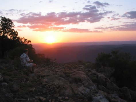
Above, the clear sky showed the Milky Way to perfection and such was the clarity that I could easily pick out the dark patches of the Coal Sacks and the misty smudges of the Magellanic Clouds.

Saturday : Lowe’s Waterhole to Campsite 2: 11 kms.
Today we would track the river westerly past the junction to Nundubbermere Falls and then on a long six kilometre run to the south, stopping somewhere, as yet undetermined, but just short of Reedy Waterhole where quadzillions of 4WD riff-raff would be lurking. A veritable village of camper trailers and safari tents even though access to Reedy and Burrows Waterholes is little better than a glorified goat track. But locals call it the “Sundown Road”.
Perhaps our modern adventurers gliding along in their all-terrain wagons could spare a thought for Sydney Skertchly, a government geologist who visited Sundown in 1897. He wrote:
“ …we had horrible weather, fog, and rain, and though we stayed a day after we had eaten our last bit of food… we were obliged to return to Ballandean, as the rain showed no sign of abating. My horse drowned himself in a waterhole and one of our men had to be sent back ill…yet I never enjoyed myself more. I shall long remember our last night. Four of us had dined of less than half-a-loaf of bread and we sat around the camp fire sipping second-hand tea, while a stockman recited Gordon’s poems as a substitute for supper.”
As for our little band of wanderers, our river outing, although not as extreme, would turn out to be a tad damp, for, as the Ranger had predicted, the river was flowing strongly over a succession of rock bars, chokes and rapids. Nary a sandy beach in sight.
Speaking of survival, several shots from a .22 rifle rang out from the far bank; I glanced around at my companions; business as usual, not a whisker twitched. Men of Steel. Across the river our weekend warriors probably thought they could bag one of the wild deer that roam the park, but failing that, there are plenty of other ferals to choose from: goats, pigs, foxes, rabbits, hares and moggies.
Good riddens many would say, although one of our fellow walkers had to be weaned off a lingering attachment to “cute little deers”. Still I didn’t have heart to mention that the Parks Service conducts regular culls of deer and such like; a recent tally being 190 deer, 580 goats, 8 pigs and 5 foxes.
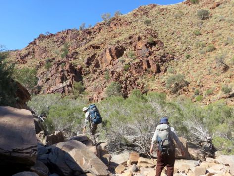
8.00 am found us skirting along the bluffs that paralleled the river, just upstream of the Nundubbermere Creek Junction. But with steep ridgelines and cliffs dipping into the river ahead it was pretty obvious that we would need to cross; a pattern of travel that was repeated with monotonous regularity for most of the day. Distance elapsed: a fraction under one kilometre from camp. This was shaping up to be one excruciatingly slow walk.
But slow is good. A chance to potter along, immersed in the ever changing riverscape: long stretches of pool and riffle, interspersed with short runs of rock and rapids; the riverine forests of she-oak, river red gums, tea-tree and bottle brush; skinks basking; and pied cormorants perched on logs, wings outstretched.
Back on the Severn, we continued picking our way along the bluff scanning for a likely crossing point; a nice dry rocky bar would do me just fine. Brian, who gets impatient with this sort of “fraffing around,” finally blew a gasket, pulled over and announced: “We’re crossing here.”
Here, was a line of rapids shooting over a waterfall; a particularly boisterous section of the river if I may say so. Bernard and I, wily old veterans of Brian’s many anti-fraffing campaigns, held back while our safe egress across to the other bank was secured.
Safe being a relative term, but apparently a too-short length of climbing tape, no anchor points, slimy rocks, unwieldy packs, racing water and three burly blokes made it ok. And it was.
In the river bed far ahead I could make out a solitary female figure of ample frame draped decorously over a boulder. Could this be the generously proportioned Mma Precious Ramotswe, proprietor of the Number One Detective Agency.
On closer inspection we revised this to merely a lady scoutmaster who had just released a gaggle of teenage girls, now straggling off into the wild. Grossly under prepared as it turned out, but it is difficult to be overly critical when the girls were out there having a go.
We caught up with the girls soon enough having retrieved one of their cast-offs… Dad’s favourite hike tent. These kids deserved better than to be let loose with ill-fitting day packs trailing an assortment of tents, tarps and those back-breaking blue sleeping mats, known by my sons as“portable concrete”.
Here is the conundrum for all youth leaders. That fine balance between risk aversion and engendering a sense of competence and adventure. The girls had no PLB and were relying on a UHF radio which was, as they soon discovered, pretty much useless in this rugged hilly terrain. But, still, we impressed to see them out there on a fairly challenging walk and, as it turned out, succeeding.
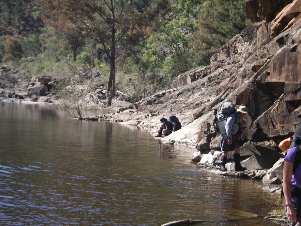
Back on the river we worked our way downstream clocking up a fraction over one kilometre an hour. With numerous crossings and water occasionally lapping at the sporrans of the resident short-arses we quickly got over trying to keep boots and socks dry and took to the water, just like the wood ducks we kept flushing up ahead of us.
As for our three Kiwi tramping companions, all this river walking brought on a nostalgia for things they thought they had left behind in The Land of the Long Black Cloud: wet boots, soppy socks and grossed-up wrinkly feet.
Late in the afternoon, much later than expected, we called it a day and set up our tents at campsite 2, a dank grove on the western bank located between Red Rock Waterhole and Rudders Waterhole, having travelled a paltry 11 kilometres for the day.

Sunday : Campsite 2 to Pump Waterhole 1.5 kms.
As the sky lightened I woke to a muted thumping outside my tent. Two chocolate eggs in terminal meltdown were stacked neatly outside my tent flap. Richard claimed that it was just Starkie pretending to be the Easter Bunny, but you and I know better.
Fortified by a breakfast of porridge and two chocolate eggs sluiced down with lukewarm coffee, I took off on the short hop to Pump Waterhole, our campsite for the next two nights. Our first task was to find a largish, flat, grassy area.
Malcolm and Brian gamely tackled yet another river crossing, foxed up a campsite on the other bank and came back with sly grins and glowing reports of our new home. But truth will out; a poxy campsite at best… if I were feeling generous in my praise, which I wasn’t.
This previously grassy river flat that had been flood-scoured leaving trails of rounded river boulders and debris piles of uprooted she-oaks. Tent sites were in short supply and so pitching our tents required some serious high order spatial sequencing.
Docking first was Bernard’s Barnum and Bailey big-top sporting a quarter hectare footprint; next came Malcolm and Jenny’s canary yellow stately pleasure dome and finally the swarm of one-maners came to rest, wherever.
In the cool of late afternoon and when seen in the lengthening shadows, our quiet little campsite grew on me, but more of that later. I believe the name Pump Waterhole may have derived from its use as a source of water for mining or for watering stock. There are precedents for this as the Beehive Mine, for example, used a steam pump to lift water 152 metres from a dam on Red Rock Creek.

After a brief respite, Brian had determined that there would be no skiving off on his watch and directed this slack and idle crew to venture forth and use their R&R time in something productive; like, say, a three or four kilometre walk to the Rats Castle via Reedy Waterhole Campsite.
Reedy was pretty much as expected: a good place to avoid over Easter. Nearby is the much larger Burrows Waterhole campsite which was named after Fredrick James Burrows, a WW1 veteran who suicided in 1934 and his grave is said to be on the northern side of the river, but I didn’t tell Brian that. He is overly fond of chasing down stuff like that.
And so it was onward to the Rats… or should have been, except for the dumb-cluck navigators. Both Brian and I had been to the Rats before but now we were approaching from a different direction.
Our walk this time went awry when the combined efforts of Richard’s GPS, my map and compass skills and Brian’s usually intuitive bump of locality all conspired to direct us down a shady beckoning track and place us on the wrong ridgeline.
Rats Castle was tantalizingly close, a mere kilometre as the crow flies but could have been on the Moon as it was now 1.00 pm our final turn-around time. So we propped where we were, savoured our lunch in a cool woodland of white cypress pines perched high above the Severn River valley.
Rats is an interesting geological feature and major landmark on the Severn. It is a ridge of hard fine-grained granite which has intruded into the surrounding metasediments of the Texas Beds, weakened during a major fracturing in the Severn River Fracture Zone. Technically it is a dyke, a vertical intrusion.
Early shepherds called it Rats Castle because when it was first seen it was home to small rock wallabies, then commonly called rats. Retracing footsteps we came to the cleared paddock we had walked through several hours previously but this time stopped to enjoy panoramic views across to Mt Lofty but more importantly Red Rock Falls, tomorrow’s objective. We could even see the ridgeline that we would follow up in the morning.

On our return to Pump Waterhole, things were on the up and up. A Sea World style slippery-dip swim, copious supplies of firewood, a now shaded campsite and a good feed and all was well in the circus.
For me at least, but not for a forlorn clutch of teenage girls, weary and sunburnt, who limped through in the fading light; one in tears. Uncle Brian took pity, showed them where they were on the map; reassured them that they were getting close to civilisation and their pick-up point and gently packed them off downstream.
As I watched their little dejected backs disappear over the promontory of rock near our tents it suddenly occurred to me that I was looking at a Rats Castle look-a-like. Closer inspection revealed it was indeed a granitic dyke intruded through the local traprock. Under our noses the whole time; how could that be? I, too, could have wept.
Monday : Pump Waterhole to Red Rock Falls: 7 kms.
An uphill sort of day; but the weather was kind, cool with light winds. Just as well for we faced a slow grind out of the Severn River Valley by way of a succession of high points: 731m, 828m, 995m, 1027m and finally reaching the high tops at 1032m, an altitude gain of 700 metres. No nav stuff-ups allowed.
Richard and I were on the yellow card. But we weren’t taking any chances with today’s route and this time had fed a truck load of waypoints into the GPS just in case the old map and compass led us astray, again.
Morning tea was on an open bald, reminiscent of the Bunya Mountains, but just an old cleared grazing paddock, but with superb views across to Mt Lofty and Red Rock Falls.
Our morning’s walk would traverse the Sundown Resources Reserve, a reminder of Sundown’s mining past. The mineral deposits formed where the Ruby Creek Granites contacted the overlying traprock (Texas Beds) or are found in fractures above the granite intrusion. Here there are occurrences of molybdenite, tungsten, copper, arsenic and tin, in fact the first deposit of tin in Australia was found on the Nundubbermere Run in 1854.
The Sundown Tin Mine opened in 1893 and operated until 1923 when it closed only to re-open in 1953 until 1956. It was by far the biggest lode producer in the area but other mines were Carpenters Gully, The Orient, and Beehive. Copper sulphides were worked at The Sundown Copper Mine and nearby Comet Mine. Arsenic was extracted in the early 1900s at Beecroft, Sundown Copper and The Orient mines.

Arsenic was an important constituent in prickly pear poison, cattle dips and a hardener for the lead in bullets. Unfortunately arsenic oxide treatment has contaminated Little Sundown Creek and I have read that walkers are advised not to drink the water in Little Sundown below the mines. Fortunately small lodes, lack of water and poor access makes any further exploitation of the reserve unlikely.
After a climb of 700m over 5.5 kilometres we reached the high range country and were about to re-enter the national park. The Queensland-New South Wales border was a mere 1.5 kilometres to our south and with the lunch worms gnawing we steered to a small shady dam.
Replete we shuffled off to set up camp on Red Rock Creek, one kilometre upstream from Red Rock Falls. We had left the drier woodlands and vine scrubs far behind and our small tent city now snuggled under a tall Eucalypt forest of yellow box, brown box and Tenterfield woolybutt . The climatic conditions at 1000 metres being cooler and moister, are conducive to the growth of this taller forest.
Red Rock Falls are etched into the Ruby Creek Granites and drop vertically a massive 150 metres. Scary. But not to Bernard who teetered, camera in hand, along the rim banging off shot after shot. I decided it was better not to watch his impending demise.
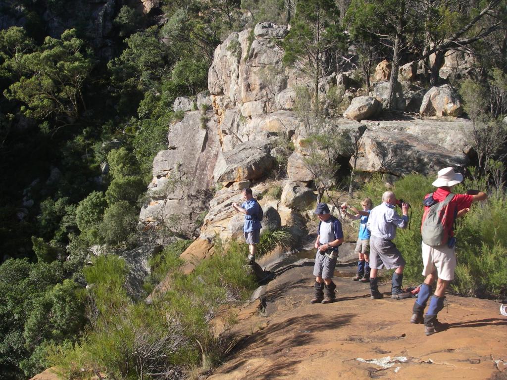
But look I did, elsewhere… scanning the precipitous clifflines for tell-tale white stains that would signal the presence of Peregine Falcons as promised in the Parks brochure. None, neither seen nor heard. So I turned my attention to the views down Red Rock Gorge to its junction with the Severn; in fact it meets the Severn very close to our campsite of Saturday night.
In the far distance, at ten kilometres to our north west was Jibbinbar Mountain (975m), our sister outcrop of Ruby Creek Granite and also the site of a government arsenic plant in the 1920s. Ruby Creek, the location for the origin descriptor of the granite that bears its name is found on the New England Tableland, close to Gibraltar Range National Park.

After more goofing around, we took our leave and clambered up to the tourist lookout above, and did touristy things…. more photos, admired the views anew and read the park info board about Sundown’s mining past and then it was off for our final night out on the track and hopefully a decent feed consisting of more than half-a-loaf of bread and second hand tea.
Tuesday : Red Rock Creek Campsite to Sundown Homestead site: 5 kms.
An easy morning’s downhill canter took us into the old Sundown site, sooner than we thought. By 10.00 am it was all over but the shouting… at Richard’s rascally Land Rover Defender if it refused to start. But it did and within the hour we dismounted at the Stanthorpe Bakery for some substantial victuals: a pie or two, spinach and fetta rolls, vanilla slices, cream buns and such like, all washed down with mugs of delicious hot coffee. Eat your heart out Mr Sydney Skertchly.