Tag Archives: Gorge Walk

A Remote Australian Wilderness: the Mawson Plateau : S.A

Mawson Plateau lies at at the northern extremity of South Australia’s Flinders Ranges. It is a very remote , inaccessible and arid wilderness. The plateau lies between 600 and 750 metres, reaching its highest point at Freeling Heights at 944 metres. A four day hike was to take us across this granite batholith by way of the gorges, waterfalls and pools of Granite Plateau Creek which drains an otherwise dry landscape. It is said to be one of Australia’s most pristine wilderness areas.

by Glenn Burns

The Mawson Plateau looking back to Freeling Heights. Mawson Plateau.
Mawson Plateau: looking back to Freeling Heights which we had descended hours earlier.

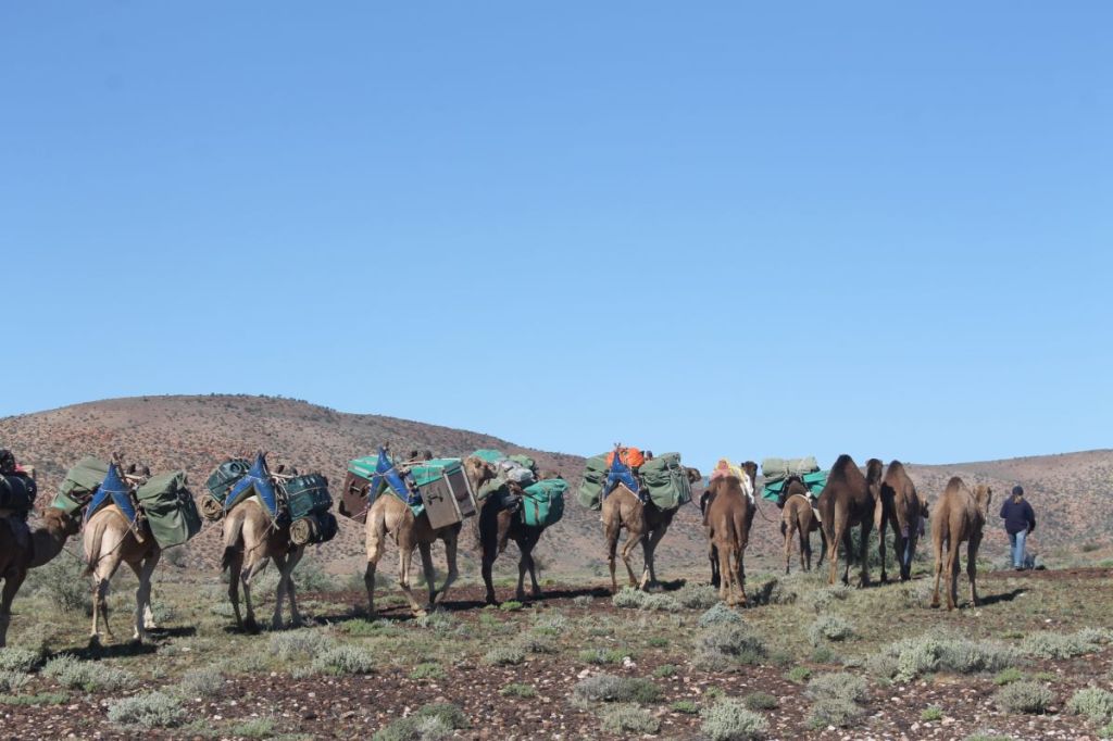
The genesis of this hike was in 2016 when I was part of a group on a camel trek from Mt Hopeless in the far north of South Australia to Umbaratana Station to the west of the tourist resort of Arkaroola in the northern Flinders Ranges.

Camel String heading south from Mt Hopeless. SA
Camel string heading south from Mt Hopeless. Far north of South Australia.

On the seventh day of our trek, as we travelled across desert plains, ahead of us rose a wall of mountains which I was told were called Freeling Heights, but also known as the Mawson Plateau. One of our fellow walkers, Peter, mentioned that he had been up onto the Mawson Plateau and generously offered to use his contacts to organise a future hike.

Silhouette of Mawson Plateau in background.
Rugged up for a bitterly cold winter’s day on our 2016 camel expedition. Silhouette of Mawson Plateau in background.

Many years ago I came across Warren Bonython’s book Walking the Flinders Ranges, the report of his epic 1967-1968, 1011 kilometre trek along the Flinders Ranges from Crystal Brook in the south to Mt Hopeless in the far north. My 2016 camel trek and the later Freeling Heights/Mawson Plateau walk would cover much of the territory covered by Bonython in his final and most northerly stage (Stage 9). This section is sometimes referred to by South Australians as the Heysen Trail Extension Section 2.

Sir Douglas Mawson

Mawson Plateau is named after Sir Douglas Mawson, Australian geologist and Antarctic explorer. In his later academic career he researched the geology of the northern Flinders Ranges. The Mawson Trail, a mountain bike trail through the Flinders and Mt Lofty Ranges is also named after him.

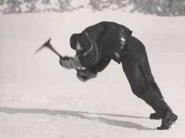
Photo of Douglas Mawson by Frank Hurley. The photo is titled Leaning into the Wind. It shows Douglas Mawson collecting ice for cooking. The winds were blowing at a constant 160 kph.

Source: Frank Hurley. Aust. Antarctic Exped. 1911-1914.

The Geography of Mawson Plateau

There is scant information on the Mawson Plateau so here is some of its basic geography based on my personal observations and a trawl of documents available in assorted books and journals. A notation on the Australian Geographic map The Flinders Ranges (2007) describes it thus: ‘Perched behind its rugged eastern escarpment, this little-known stronghold is a maze of weather-hewn granite crags and boulders. After rainstorms the deep trough-like waterholes along its creeks form the largest natural body of water in the Flinders – a priceless ecological haven for native fish and water plants.’

Location

Mawson Plateau, 300 6′ 38″ S and 1390 25’19” E, is part of the northern Flinders Ranges complex on the Mt Freeling pastoral lease in South Australia. It lies adjacent to the north eastern boundary of the famous Arkaroola Sanctuary.

Location of Mawson Plateau. SA.
Source: Geoscience Australia.
Geology and Landforms

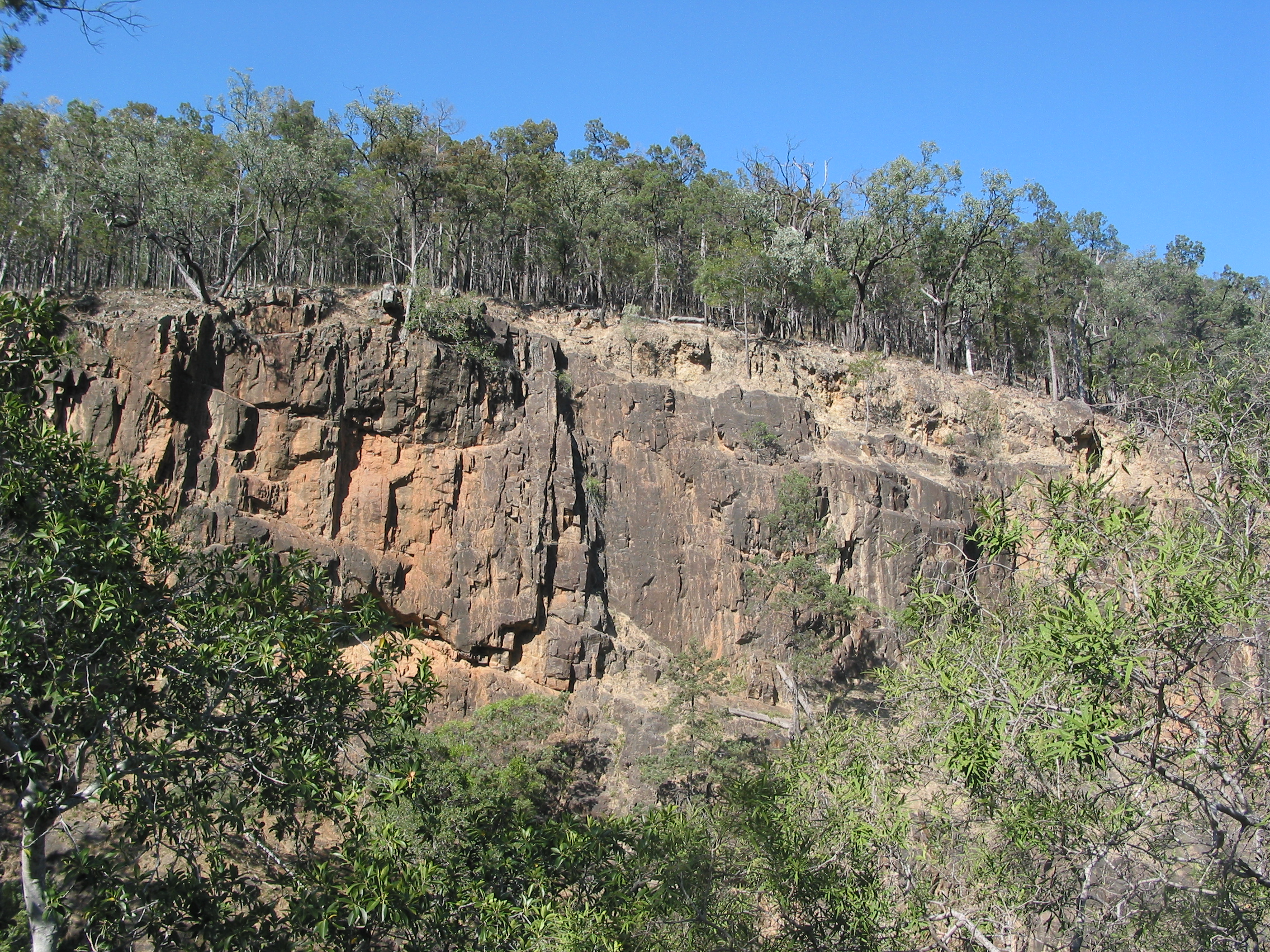
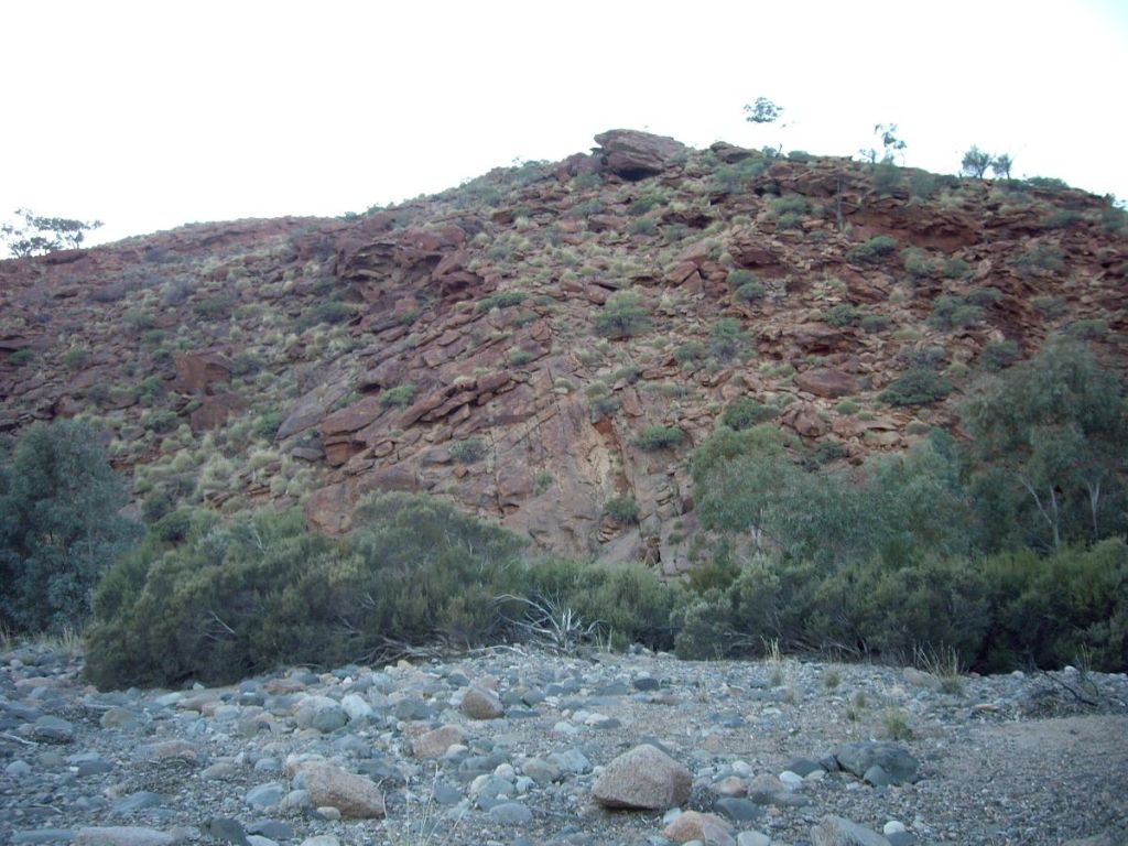
Mawson Plateau is a 70 square kilometre granitic batholith with an average elevation between 600 and 700 metres. Its southern boundary is delineated by the higher Freeling Heights which rise to 944 metres. The eastern boundary is a spectacular 250 metre fall called the Granite Escarpment, while the northern and western boundaries are bounded by Hamilton Creek. From its headwaters high up in Mawson Plateau, Hamilton Creek (intermittent) drains initially north east to Moolawatana Station then swings south east from which it finally decants (rarely) into Lake Callabonna, a dry salt lake. Interestingly, Callabonna is an important site for late Pleistocene fossils.

Satellite View of Mawson Plateau.
Satellite view of Mawson Plateau.

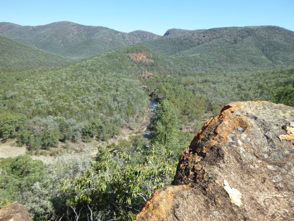
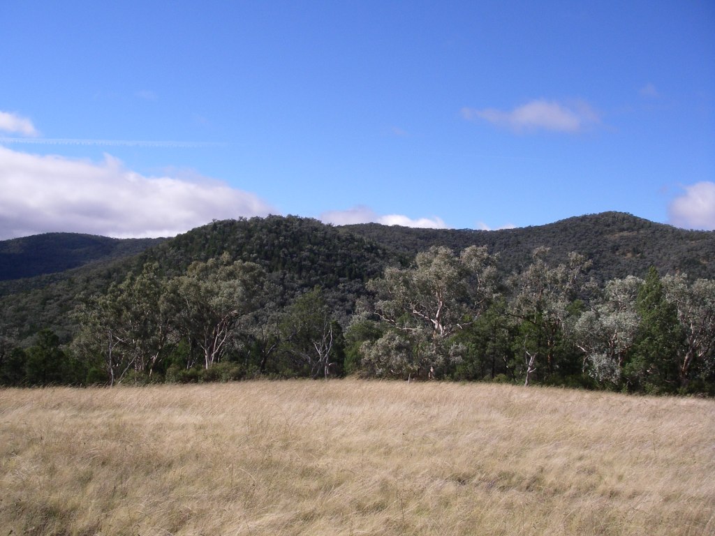
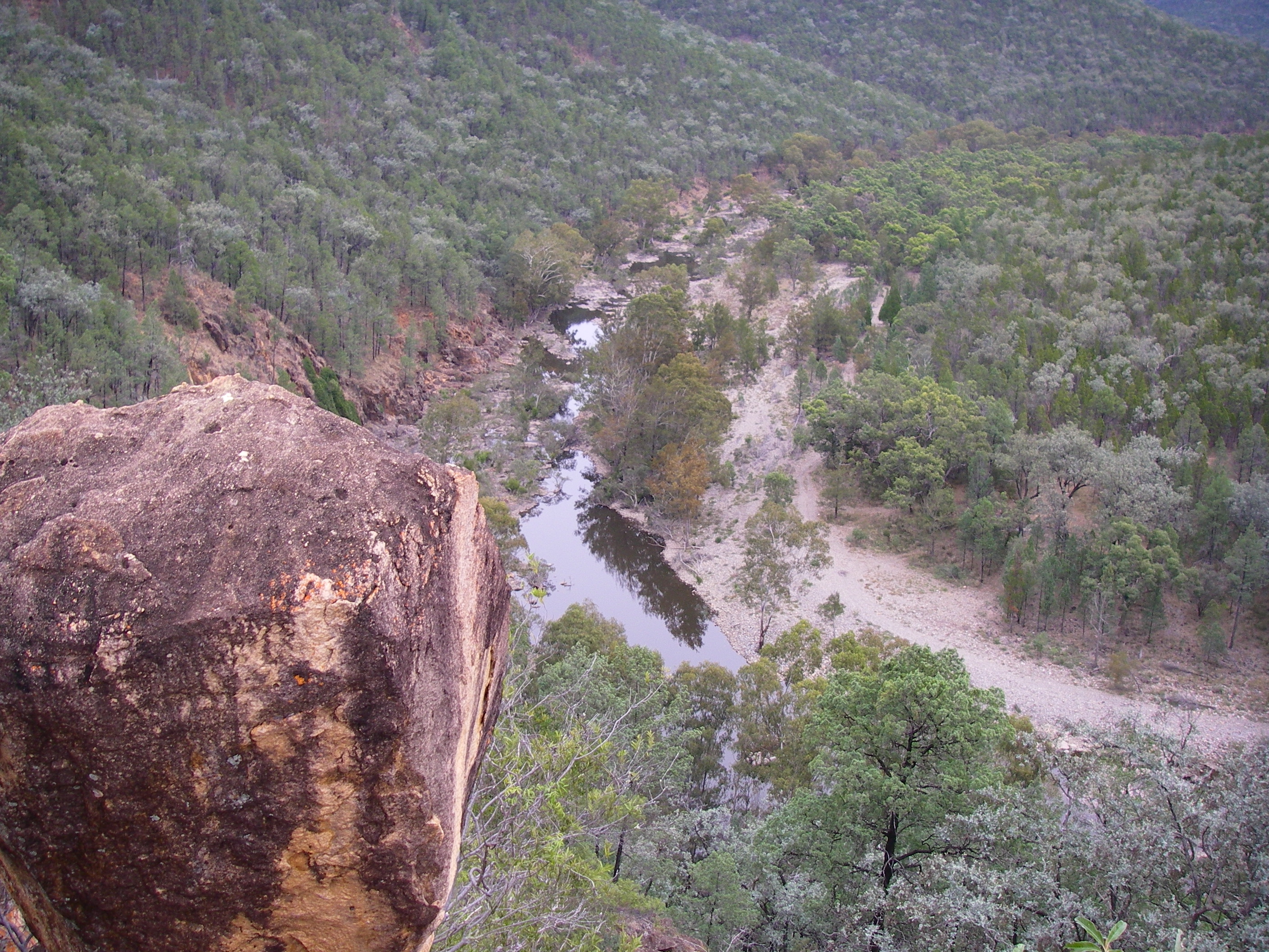
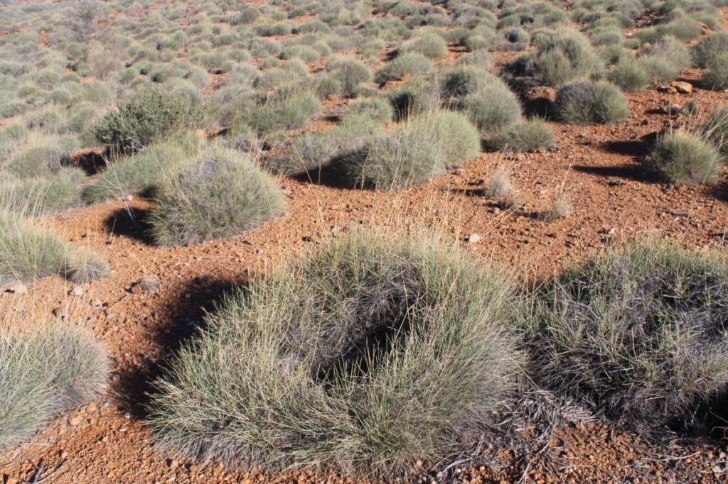
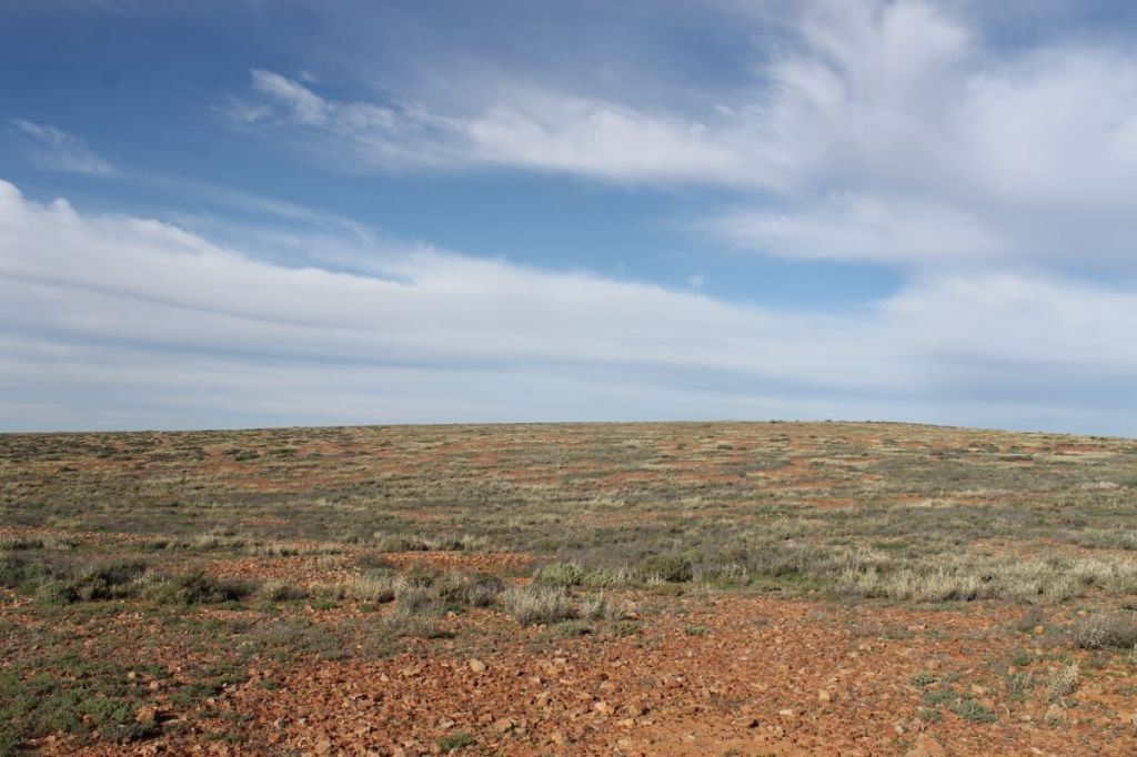
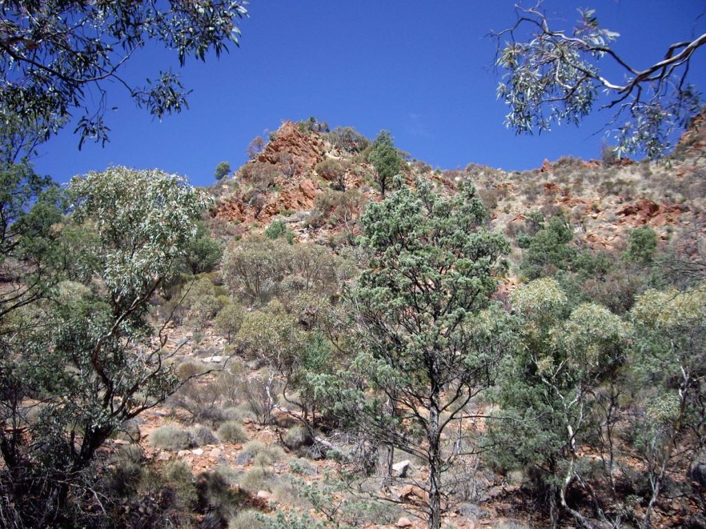
The plateau is a tangled landscape of sandy creek beds, sand plains, rocky ridges and vast expanses of granite, covered by a mantle of loose, shattered rock and huge granite tors. Its surface has been intricately dissected by Granite Plateau Creek and Saucepan Creek, both non-perennial tributaries of Hamilton Creek. Granite Plateau Creek has cut deeply into its bedrock to form an extensive gorge featuring dry waterfalls, pools, deep potholes and sandy beaches. It was this feature that we would use to traverse the plateau which is otherwise totally waterless.

The Mawson Plateau.
Photo by John B. The Mawson Plateau: a landscape of rocky ridges, vast expanses of granite pavement, dry creek beds and deep gorges.

The highest part of the plateau, Freeling Heights, is composed of Freeling Heights Quartzite, of Mesoproterozoic origin dating back 1590 to 1580 ma. These metasediments are part of the Radium Creek Group, some of the oldest rocks in the Flinders Ranges.

The main plateau surface is a granite of Late Ordovician – Silurian age, 442 ma, intruded into the older rocks. The plateau is a major leucogranitic intrusion called British Empire Granite (BEG). BEG leucogranite is light coloured with almost no dark minerals. It is medium to coarse-grained and highly radioactive. Its radioactivity is another interesting story; too long to be recounted here. BEG also contains numerous pegmatites. Pegmatites form in the final stage of a magma’s crystallisation. Thus they contain exceptionally large crystals and minerals that are rarely found in other types of rocks. Spodumene (an ore of lithium), tourmaline, topaz and beryllium are all found with pegmatites.

Granite terrain of the upper Granite Plateau Creek. Mawson Plateau.
British Empire Granite exposed in Granite Plateau Creek. Mawson Plateau.
Climate

The Mawson Plateau lies in one of Australia’s major arid bioclimatic regions, the Eyrean Region. The Bureau of Meteorology classifies its climate as a Desert climate characterised by hot and persistently dry seasons. For the climate afficionados among you, its Koppen climate classification is BSh, a hot semi-arid climate. The plateau nestles between the 200 and 250 mm isohyets and its rainfall displays high variability. Being caught in Granite Plateau Creek during a very rare flood event would be best avoided. That said, winter walking weather is outstanding. Expect mild sunny days, deep blue cloudless skies and cool nights all of which make for an unforgettable experience.

Temperature and Rainfall Statistics for Arkaroola SA. 318 m
August
Mean Max Temp oCMean Min Temp oCMean Rainfall mmMean Rain Days
19.14.614.42.1
Observations on fauna and plant communities
Fauna

Reptiles form a significant and the most observable part of the faunal assemblage.

Shingleback (Trachydosaurus rugosus).
Shingleback (Trahydosaurus rugosus) basking in weak winter sun.

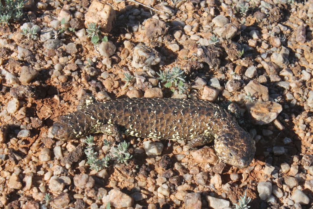
Skinks, geckoes , and dragons were all seen, but no snakespossibly they were in hibernation.

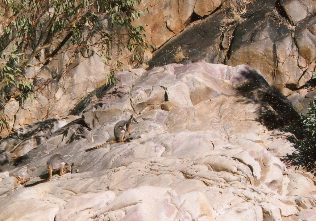
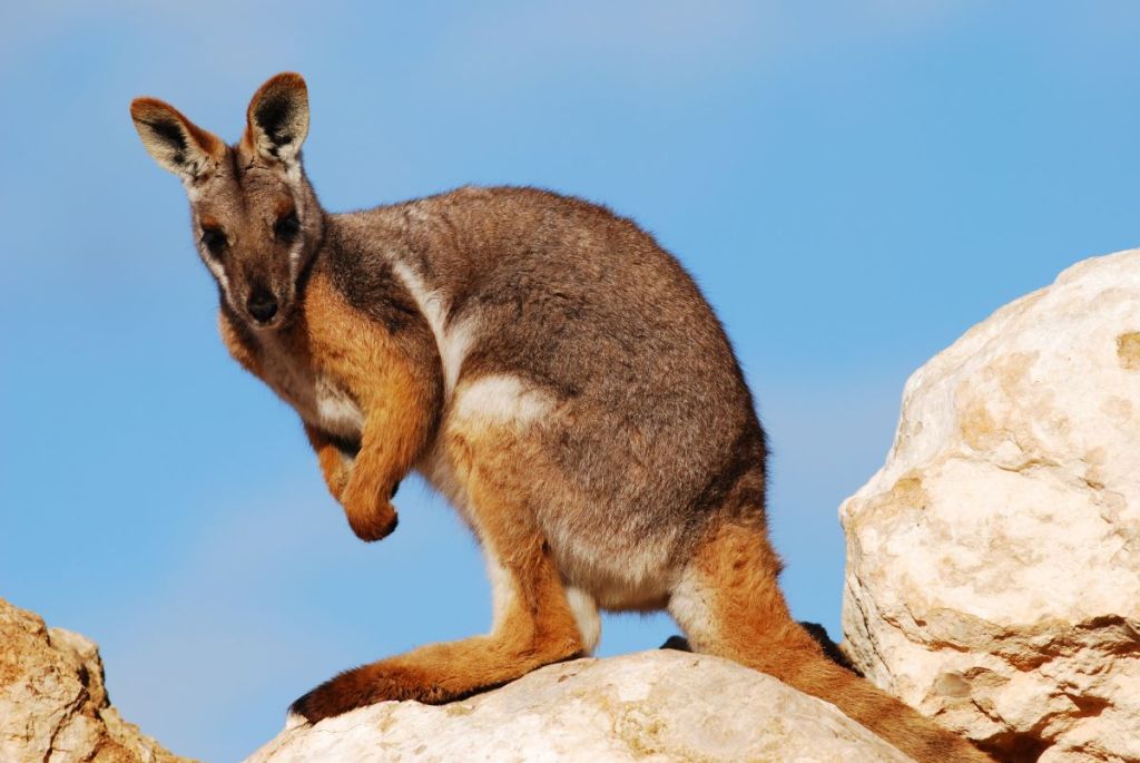
Some rockholes hold water permanently even in extended droughts. These are refuge sites for tadpoles, fish and frogs including an undescribed species (Crinea sp). Mammalian fauna includes Euros and if you get very lucky, the endangered Yellow-footed Rock Wallaby. These spectacular macropods are easily identified by their yellow feet and tiger banded tails.

Yellow-footed Rock Wallabies in northern Flinders Ranges
Yellow-footed Rock Wallabies sunning themselves on a rock shelf in northern Flinders Ranges.
Yellow - footed Rock Wallaby
By Peripitus – Own work, CC BY-SA 3.0, Yellow-footed Rock Wallaby.

Bird species recorded were Wedge-tailed Eagle (many and obvious), Australian Raven, White-faced Heron, White-browed Babbler, Singing Honeyeater, Wood Swallow and Australian Magpie-lark. A dismal effort if truth be told, but I can always claim that my eyes were always focused on the next foot-fall.

Plant communities

Freeling Heights: a hill-top heath community of Porcupine Grass (Triodia irritans), Broombush (Melaleuca uncinata), Fringe Myrtle (Calytrix tetragona), Wax Flower (Eriostemon sp) and Spidery Wattle (Acacia araneosa).

Spinifex. Mawson Plateau.
Triodia irritans.

Granite Plateau Creek: A woodland of River Red Gum (Eucalyptus camaldulensis) and White Cypress Pine (Callitris glaucophylla). The shrub layer was an association of Wild Rosemary (Cassinia laevis), Hopbush (Dodonaea viscosa ssp angustissima), Cassia (Senna artemisioides) and Yucca ( Xanthorrea quadrangulata).

Xanthorrea quadrangulata : Mawson Plateau.
Xanthorrea quadrangulata.
River Red Gums in Granite Plateau Creek. Mawson Plateau.
Gallery forest of River Red Gums: Eucalyptus camaldulensis.

Gorge tops and open granite terrain: The few plants I could identify: Mulga (Acacia aneura), Corkbark (Hakea ednieana), White Cypress Pine (Callitris glaucophylla), Native Orange (Capparis mitchellii) and Bell Fruit Tree or Camel Poison (Codonocarpus pyramidalis).

Aboriginal Occupation

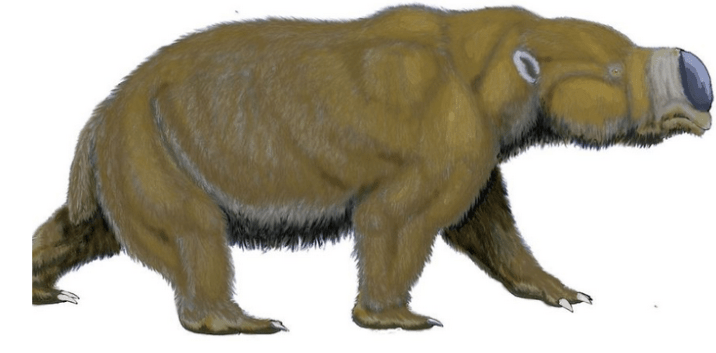
The northern Flinders Ranges were occupied at least from some 49,000 years ago. This date was obtained from a site known as the Warratyi rock shelter, south of Mawson Plateau. Evidence from Warratyi shows the use of key technologies such as stone axes and ochre. The site also had evidence that humans existed alongside of, and hunted megafauna. Excavations to a depth of one metre produced 4,000 artefacts and 200 bone fragments including some from Diprotodon optatum , a giant wombat-like creature.

Diprotodon optatum
Diprotodon optatum

It is likely that aborigines would have camped in the Granite Plateau Creek catchment as there are a number of permanent waterholes. As the climate of inland Australia dried these waterholes would have been vital refuge sites for inland aborigines.

At the time of first European contact the tribal groups occupying the northern Flinders Ranges were the Yardliyawara and the Wailpi. European settlement fragmented their social and economic structures so that today these tribes are known collectively as the Adnyamathanha ( hills people ). Fortunately, the Adnyamathanha have been able to maintain their cultural identity and links to the northern Flinders.

Further reading:

Map: Yudnamutana: 1:50 000.

Map: Frome: 1:250 000.

Map: Flinders Ranges: 1:550 000 (Aust. Geog.).

Bonython, W.C: Walking the Flinders Ranges (Rigby, 1971).

Barker, S et.al. eds: Explore the Flinders Ranges (RGSSA, 2014).

Mincham, H: The Story of the Flinders Ranges (Rigby,1974).

Pledge, N: Fossils of the Flinders and Mt Lofty Ranges (SA Museum, 1985).

Cawood, M. and Langford, M: The Flinders Ranges (Aust. Geog., 2000).

Saturday : Arkaroola to Edward Springs: 50 kms

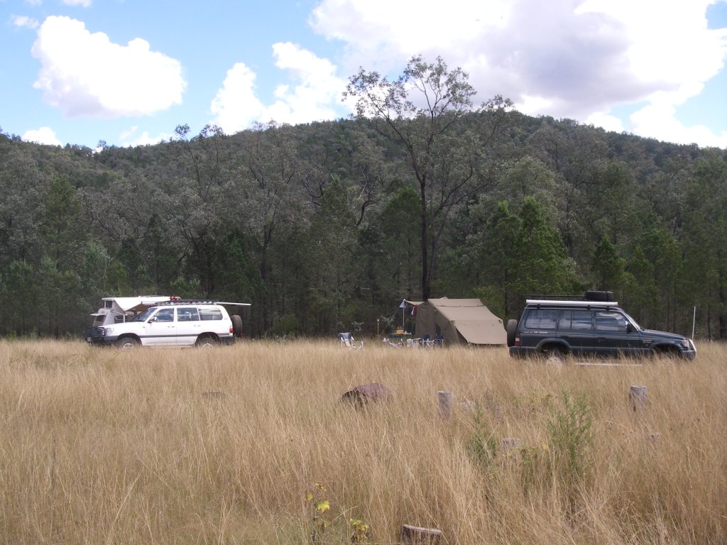
And so, on an annoyingly aberrant cool, overcast August day we were lurching and grinding over old 4WD station and mining tracks heading for our base camp at somewhere called Edward Springs (springless and definitely waterless as far as I could tell). The South Australians had very kindly organised to squeeze us into one of their off-road vehicles for the trip in. The tracks, in places, were little better than wheel ruts cutting across a landscape that varied between rock, sand, sandy creek beds and clumps of spinifex. The drive in was meant to take only a few hours from Arkaroola giving a walking party time to climb Freeling Heights (944 m) and set up camp that same afternoon. The best laid plans of mice and men”.

The ‘tracks’ took their toll on a Subaru’s tires, leaving a Landrover Defender and a Toyota Prado to ferry in seven walkers and five base campers. Suffice to say we couldn’t all fit into the two remaining cars. The overflow took to hoofing the rest of the way in to our base camp (wherever that was). But I was happy enough to be out walking, even under a dark, threatening sky. The view ahead was spectacular. Across the undulating plains rose the long, flat profile of the Mawson Plateau. Later in the afternoon, at the end of a vague track, under the shadow of Freeling Heights we found the earlier arrivals. Tents were up and a camp fire going.

Base camp at Edward Springs on a tributary of Mac Donnell Ck. Mawson Plateau.
Base camp in Mac Donnell Ck.

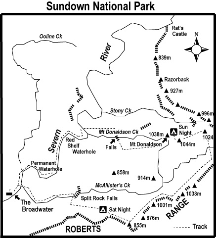
Our campsite was in the dry bed of MacDonnell Creek, a major feeder of the Hamilton River ( GR: 416657 Yudnamutana 1: 50,000 AGD 84 ). Tomorrow’s access to Freeling Heights was, initially, via a small unnamed tributary of MacDonnell Creek which flowed north west off Freeling Heights and into MacDonnell Creek about 500 metres north of our base camp.

The sight of a welcoming blaze somewhat improved my mood as I surveyed our setting which could, at best, be described as desolate. A far cry from my favourite haunts in the rolling alpine meadows of Kosciusko National Park. 
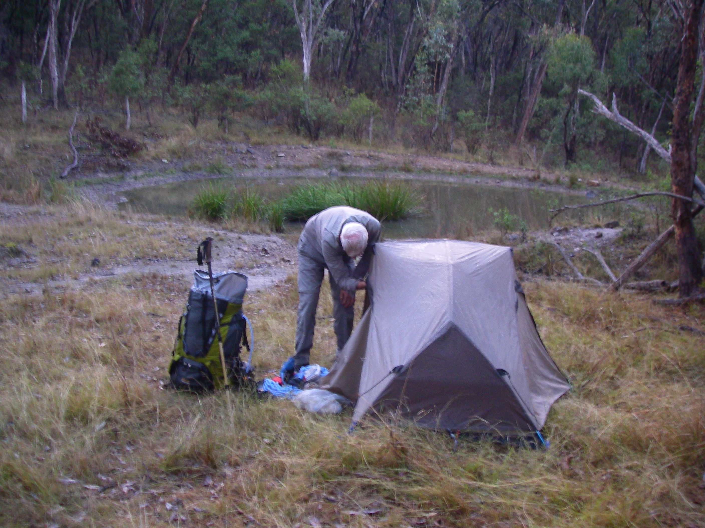
Here we were tucked up into a dry creek bed with a maze of dark glowering hills to our backs, and a thickening bank of clouds gathering overhead. Creating a level tent pad in these fields of shattered rock and clumps of spinifex proved a bit of a mission.

Darkness closed in quickly but a small community gathered around the fire to prepare dinner and work our way through trivia questions while we cooked a meal. For some, dinner was an exotic feed prepared by Jack. My options were pretty limited, a reconstituted dried meal. But here’s the thing. Our South Australian friends catered for a cast of thousands so there were invariably seconds for everyone, myself included. No danger of impending starvation on this trip.

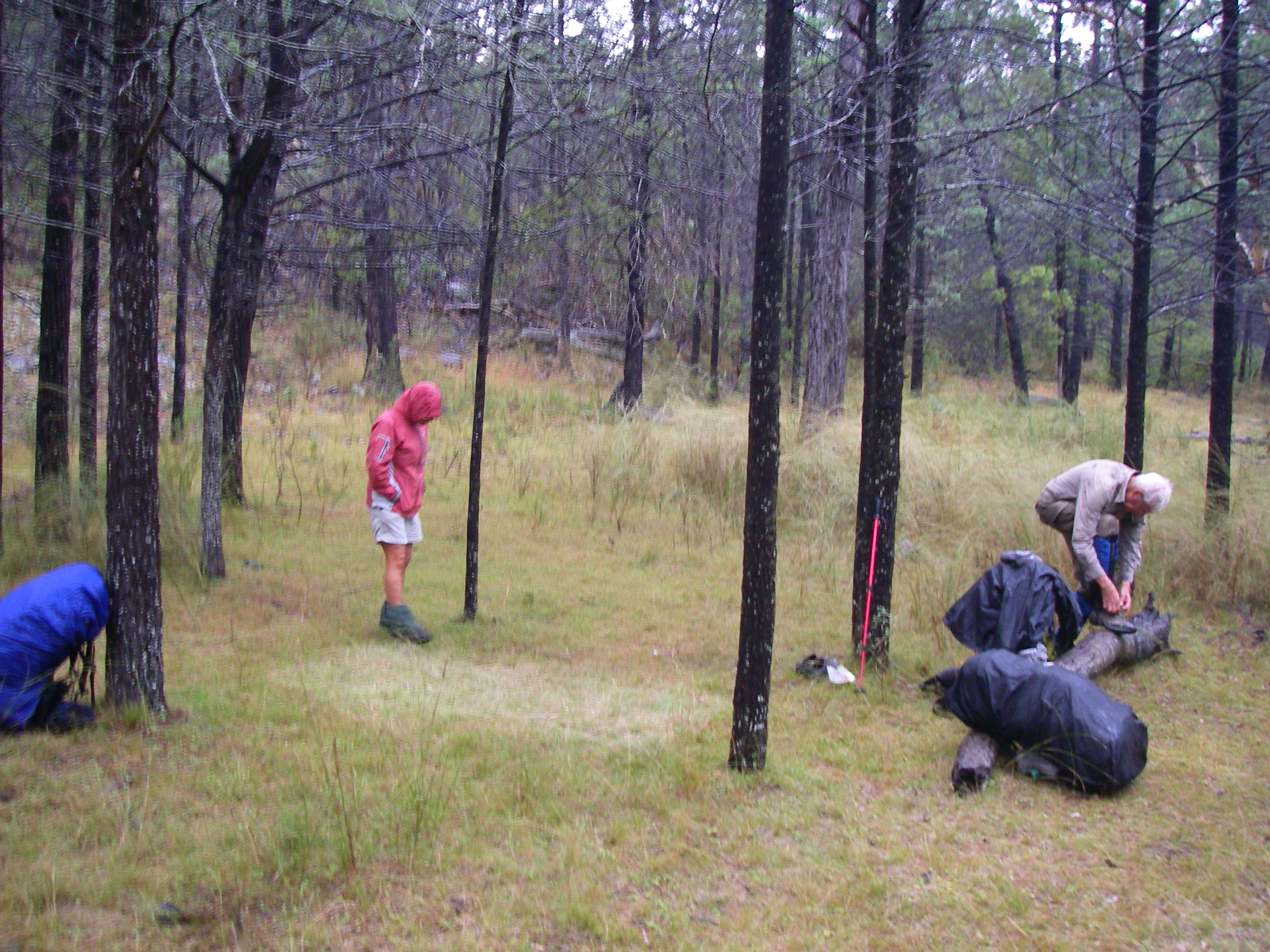
Some of us sported comfortable folding chairs while the hardier South Australian types constructed Fred Flintstone lounge chairs from the abundant sheets of quartzite living on the creek bed (pretty uncomfortable actually, but nobody was going to admit to that). Our campfire reveries were cut short by an unwelcome visitor, very light drizzle. Not predicted and certainly unexpected in this arid environment. By 8.00 pm the group had dispersed to their respective camping arrangements in preparation for our 8.00 am departure on the morrow.
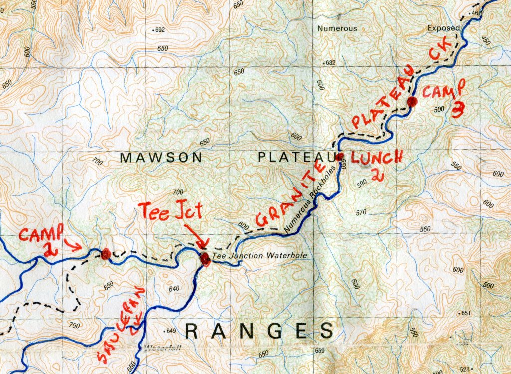
Sunday: MacDonnell Ck/ Edward Springs Base camp to second overnight camp at Tee Junction Waterhole: 10 kms.
Mawson Plateau Hike: annotated map of first section.
My annotations of the route marked on my Yudnamutana 1: 50,000 map sheet.

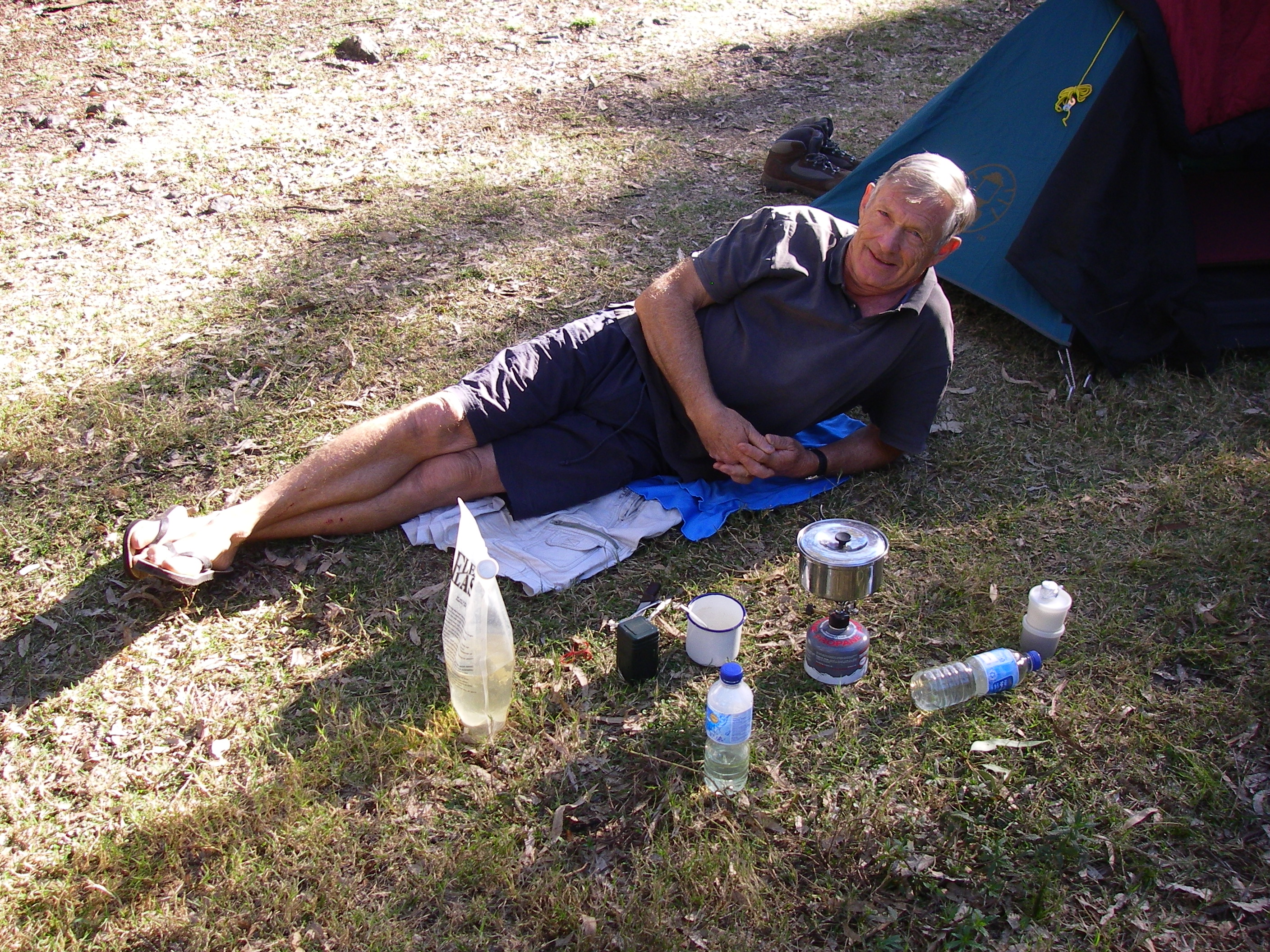
Being creatures of habit, John and I emerged into the chill darkness soon after 5.30am. While Susan caught another twenty winks John tizzied up the fire and a billy was put on to boil for our tea and coffee. 
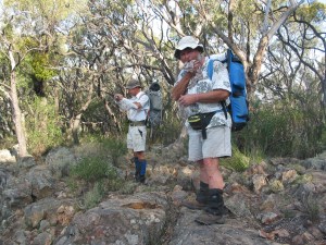
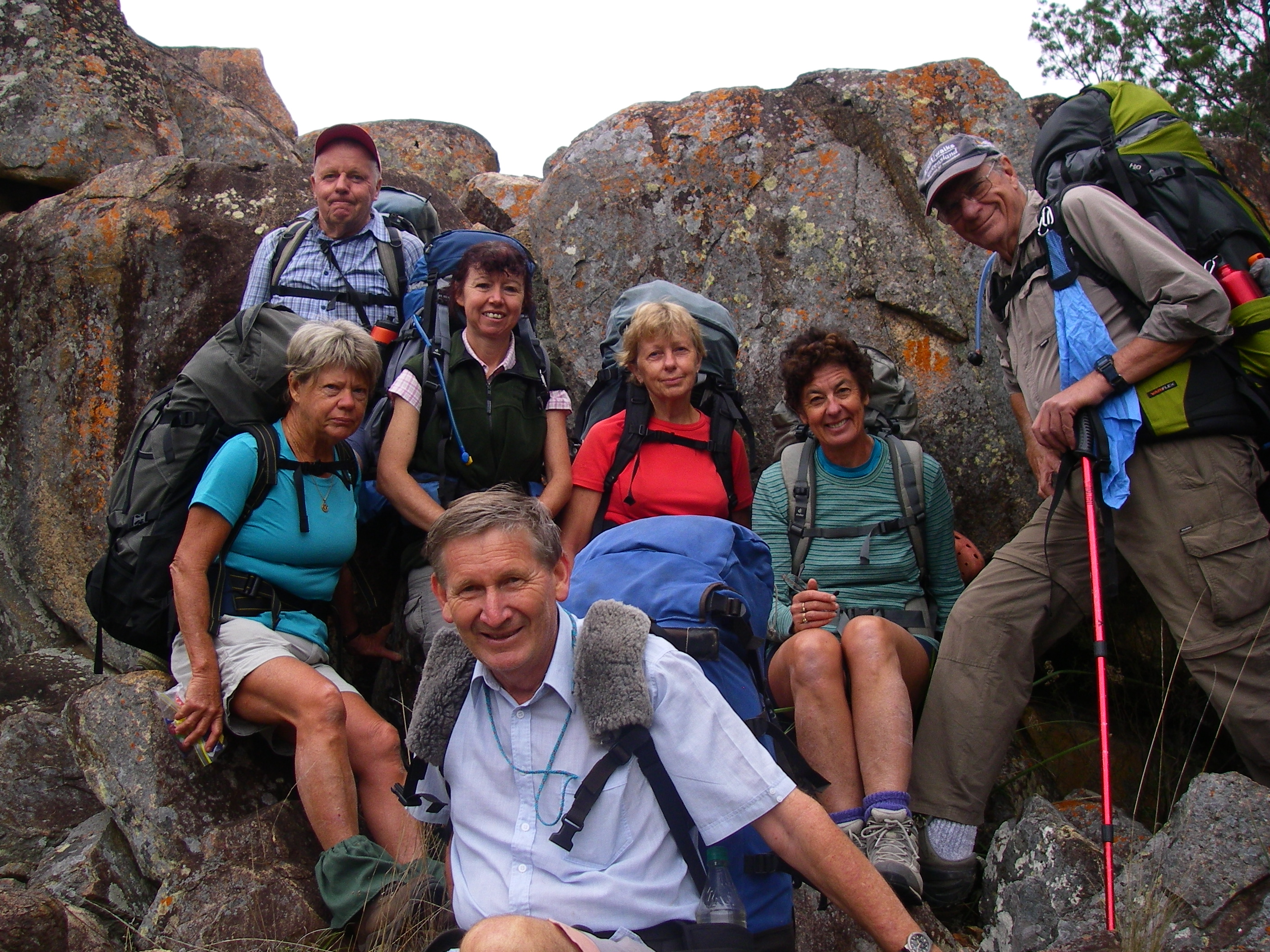
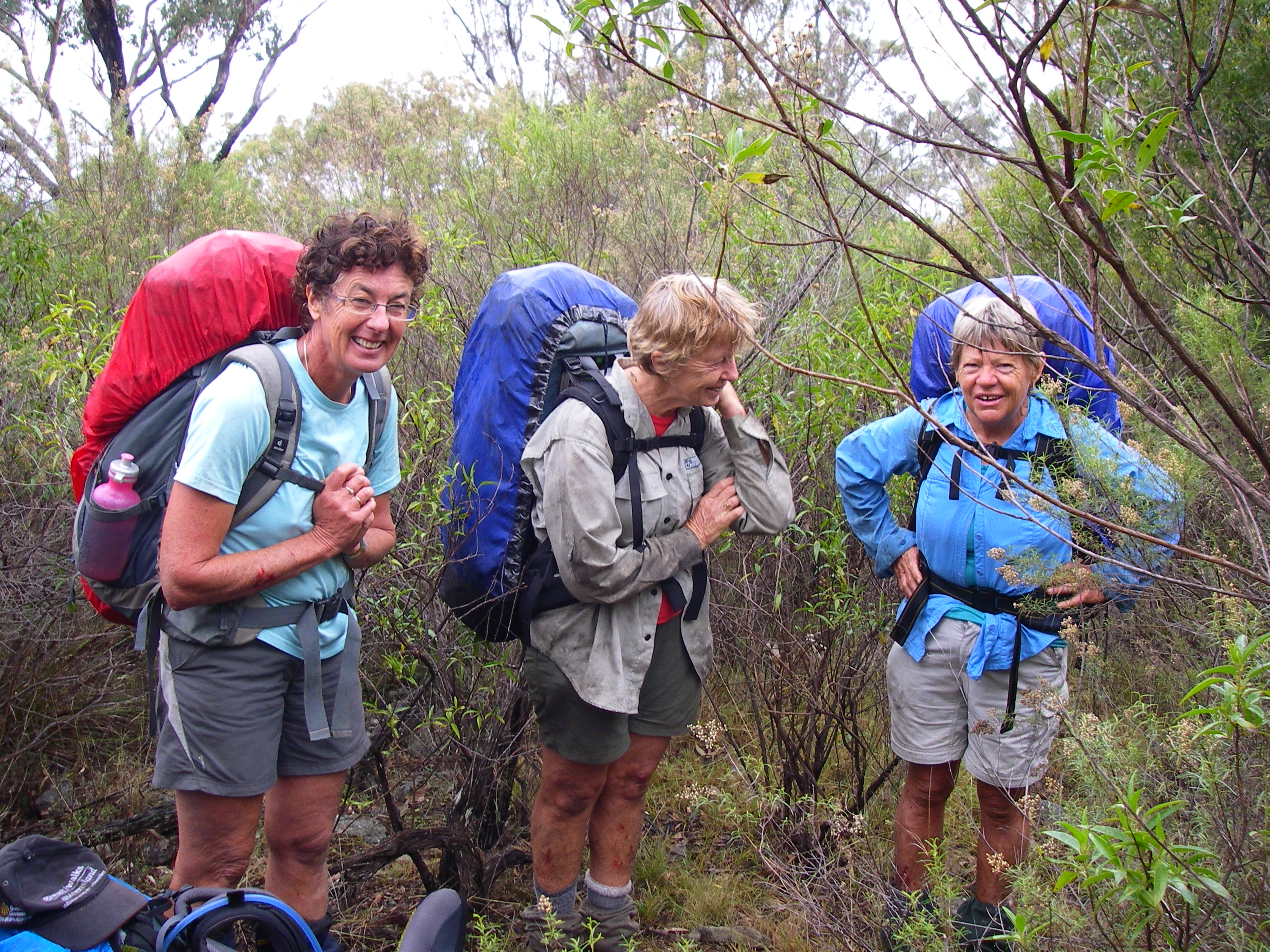
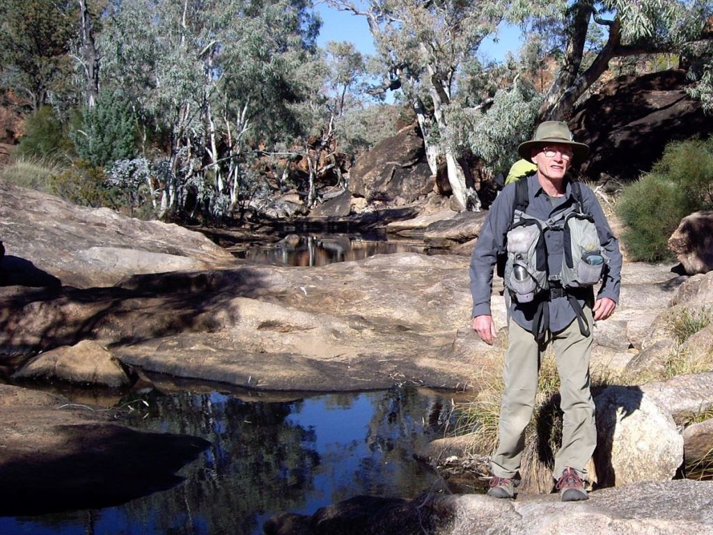
By 8.00 am our hiking party of Paul , Rob , Mike and Jack (from South Australia) and Susan, John and I (Queenslanders) mustered at the start of a mining track leading south east out of the campsite; leaving the base campers to climb Freeling Heights at their leisure. The sky had cleared to a brilliant cloudless blue as only a desert sky can.

Our climb to Freeling Heights would take several hours even though the altitude gain was only 300 metres. It was a landscape of loose rocks, thick scrub and tangled hills dissected by numerous dry gullies. As well, we were dragging along litres of water to see us through the day until we reached Tee Junction Waterhole late in the afternoon.

Foothills on the climb to Freeling Heights at 944 metres. Mawson Plateau.
Foothills on the morning’s climb to Freeling Heights: 944 metres. Freeling Heights hidden from view.

The route, which didn’t seem at all obvious to myself or our South Australian friends, involved following up the mining track which soon petered out. As our original leader had opted out of the hike, I never quite figured out who the substitute leader was or who was doing the navigation. But everyone chipped in and things seemed tickety boo. From here it was down into a dry creek bed, scrub bashing and scrabbling over boulders until the creek became impassable and we were forced out onto a ridge leading to the stony western rim of Freeling Heights at about 900 metres.

On the quartzite ridge heading for the summit of Freeling Heights. Mawson Plateau.
The stony quartzite ridge leading to the summit cairn of Freeling Heights at 944 metres.

It was clear to me by now that the group’s modus operandi was pretty laissez-faire. Walkers scattered across the landscape with the fastest walkers meeting up with whoever was leading at the time ( a moveable feast). Then followed a chat about navigating to the next landmark. Not really a problem up here on the Freeling Heights high tops, but later on, by mid afternoon, a niggling issue for those lagging behind when we descended onto the sandplains and dense Ti-tree thickets below Freeling Heights.

The Navigators : Mawson Plateau.

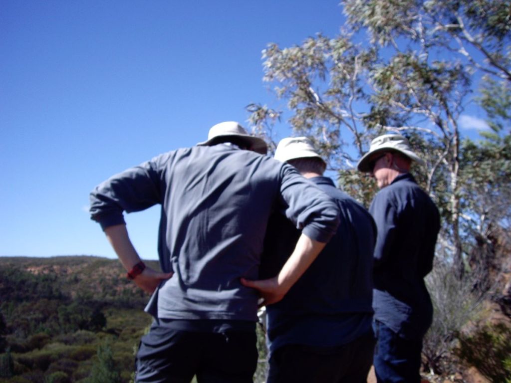
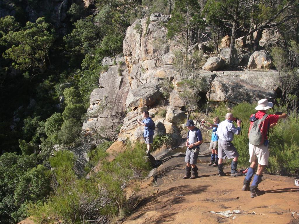
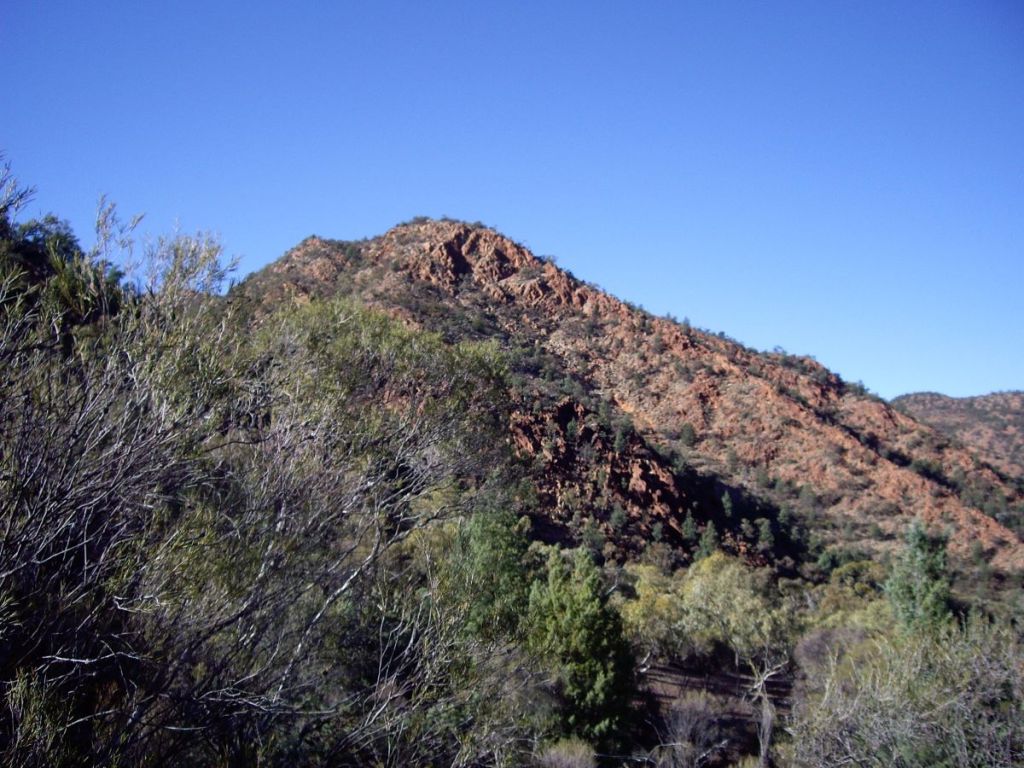
A brief stop on the western rim of Freeling Heights and we tore off again to find the impressive drystone cairn marking the summit at 944 metres.

The summit cairn of Freeling Heights at 944 metres. Mawson Plateau.
The summit cairn of Freeling Heights at 944 metres.

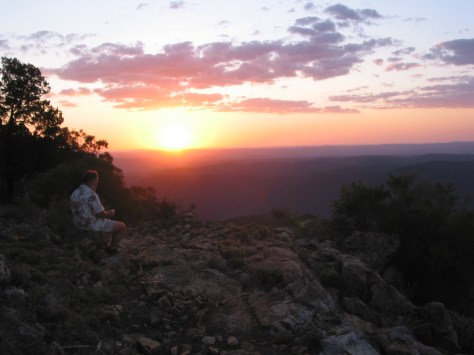
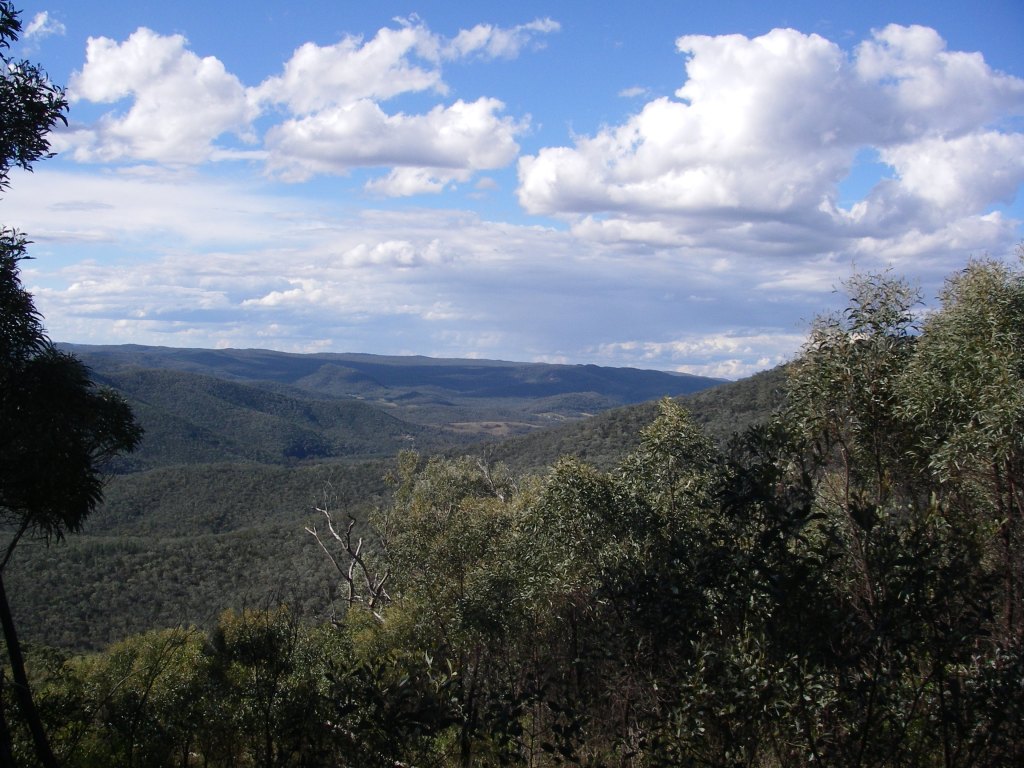
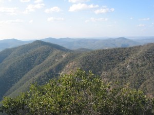
We propped here for morning tea and to take in the very impressive views out over the tangled ‘all slopes’ topography and out onto the waterless and featureless plains beyond. In 1840, the explorer Edward John Eyre climbed a low ‘haycock- like’ peak on the plains just to our north and described the scene as ‘cheerless and hopeless’. He turned away and beat a hasty retreat to the south.

Mt Hopeless. SA.
Mt Hopeless SA.
Plains north of Mt Hopeless. SA.
View out over plains from Mt Hopeless.
View from the summit of Freeling Heights out towards the Hamilton River and plains beyond.
View from Freeling Heights over a tangled foothill terrain of ridges, gullies and hills. Looking towards the dry bed of the Hamilton River and featureless plains beyond.

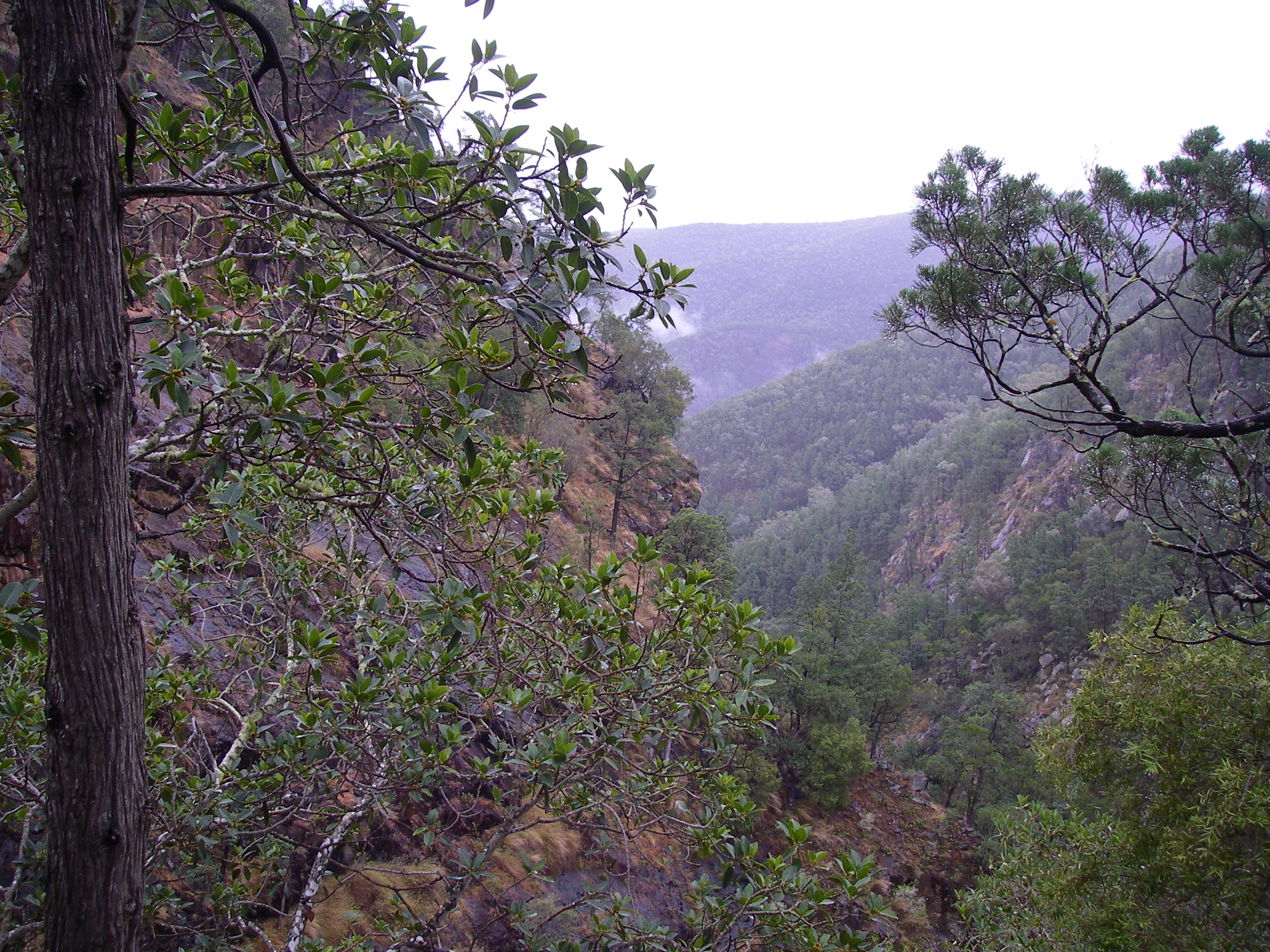
From Freeling Heights we dropped 250 metres down a steep escarpment covered in shattered quartzite onto a sandplain forming the headwaters of the Granite Plateau Creek system. For the next three days we would follow the gorges and sandy bed of Granite Plateau Creek out to its junction with Hamilton Creek near where, hopefully, the exit base camp had been established. Our base campers later reported that the drive from MacDonnell Creek/Edward Springs to Hamilton Creek had been long and tortuous, occupying most of the day. Apparently not something they were keen to repeat.

Mawson Plateau landscape.

As the creek bed and its fringing flood plain were choked with dense thickets of White Tea-tree (Melaleuca glomerata), we edged uphill and took to the lower hills and ridges, all the while trying to maintain a line of travel to intersect with Tee Junction Waterhole five kilometres hence. But with fellow walkers spread over the landscape it was a toss up as to who was leading and who to follow . The low ridges and scrub made it difficult to see other walkers. But as we were not leading the walk and the terrain was unfamiliar, I kept stumm about any thoughts I harboured that we should be keeping together. Anyway, our leaders seemed to have the navigation under control.

View across sand plain to Freeling Heights. Mawson Plateau.
Photo: John B. View across sand plain to Freeling Heights.

I have done quite a bit of walking with John and Susan and I became aware that they were travelling much slower than they usually do and not keeping up with the rest of the group.

By mid-afternoon it dawned on me that Susan was hobbling along nursing a dodgy ankle or foot; apparently damaged several hours ago on Freeling Heights. When we finally dropped into Granite Plateau Creek late in the afternoon, John, Susan and I decided to take an early mark and propped at the first decent waterhole. It was agreed that the rest of the party would head downstream to Tee Junction Waterhole for the first night’s camp.

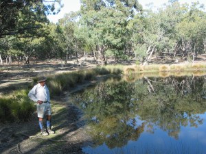
While Susan soaked the injured ankle/foot in the waterhole , John and I set up tents, collected firewood (too easy) and got the campfire going. This was a campsite par excellence: sandy tent platforms, abundant firewood and heaps of water (once purified). We would be very comfy here for the night ( GR: 475678 Yudnamutana 1: 50,000 AGD 84 ).

Campsite on Granite Plateau Creek. Mawson Plateau
Photo: John B. Dismounting & getting ready to set up camp two in Granite Plateau Creek. Sandy tent pad, heaps of firewood and water.
Monday: Tee Junction to third overnight camp: Granite Plateau Creek: 6.5 kms.
Map of Mawson Plateau
My annotations on the route marked on my Yudnamutana 1:50,000 mapsheet.

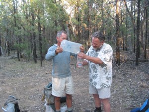
A very early start as we had promised the others that we would catch up with them at Tee Junction Waterhole as soon as possible. It is called Tee Junction because Saucepan Creek joins Granite Plateau Creek at an angle of 900. With Susan’s foot strapped and booted we nipped off downstream. After one and half kilometres of creek hopping and thrice longer time wise than expected, we found Team SA about 8.30 am, waiting patiently. In a previous life and in a far away continent, Jack had worked as a paramedic and he set to and re-strapped my bodgy job on Susan’s ankle.

Near Tee Junction waterhole, Mawson Plateau.
Near Tee Junction waterhole.

This done, we cooked up a plan to get Susan through the walk as there was no possibility of turning back. The base birds at our Edwards Springs HQ had already flown the coop. The Landrover and Pajero would, by now, have started the long drive around to Hamilton Creek via Greenhill Hut and Valley Bore. The plan was to ease Susan through the rest of the walk. Back at Tee Junction Waterhole we split into two groups. The South Australians would continue downstream at their own pace leaving John to assist Susan while I scouted ahead to find the easiest route. They would wait for us to catch up at lunchtime and we would meet again for the evening camp GR: 475678 Yudnamutana 1:50,000 AGD 84)

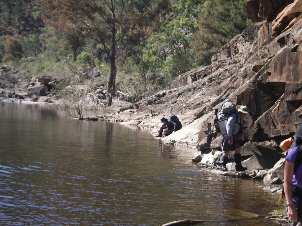
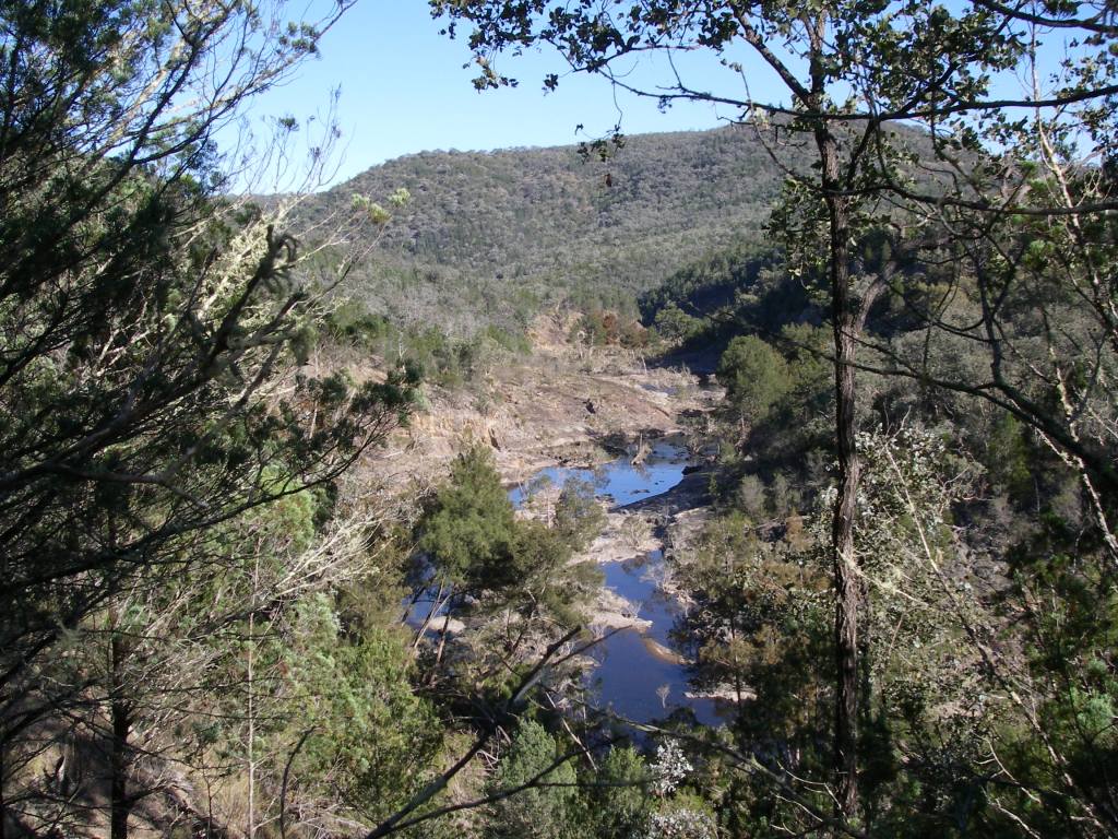
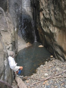
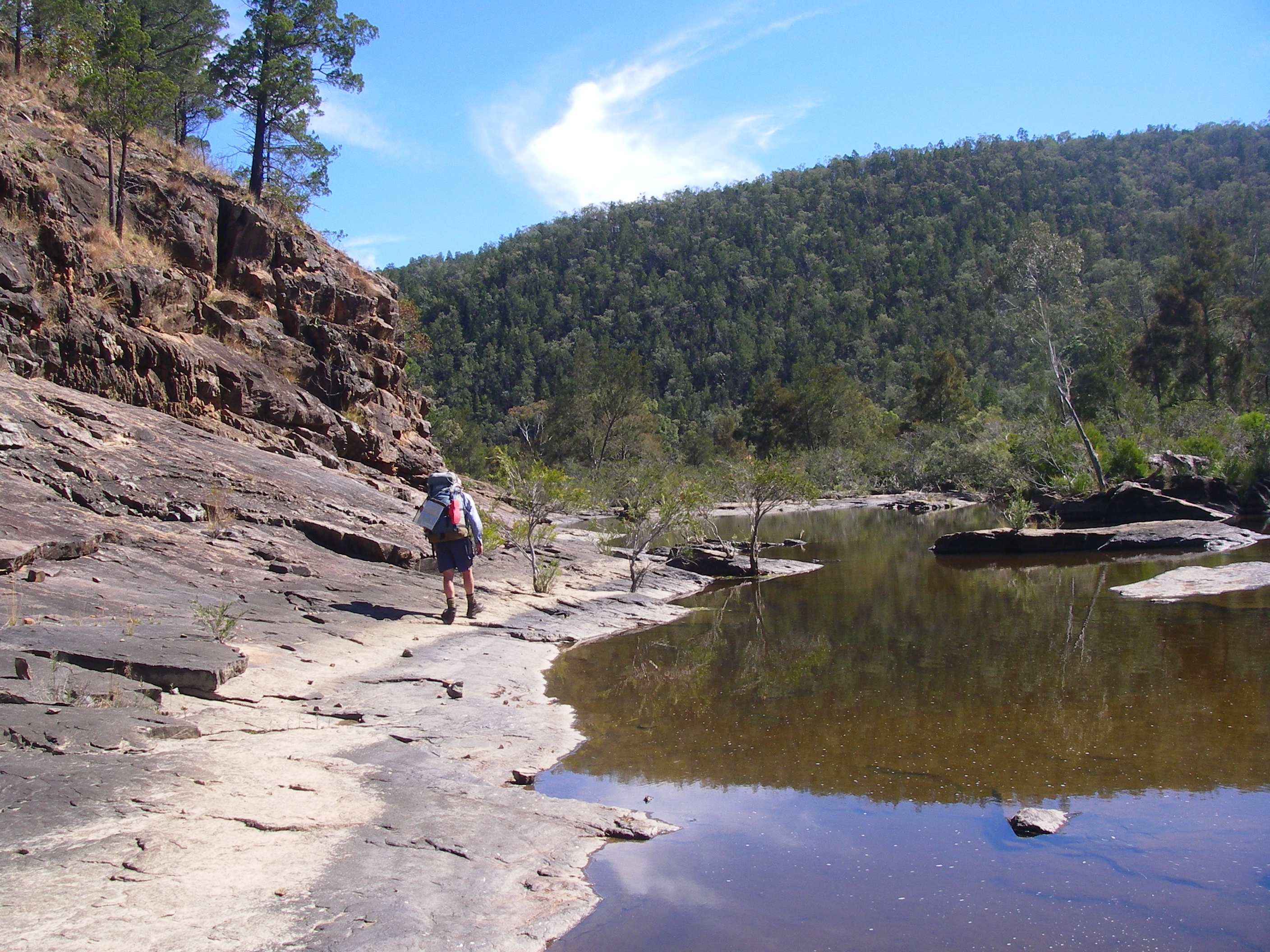
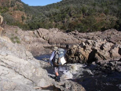
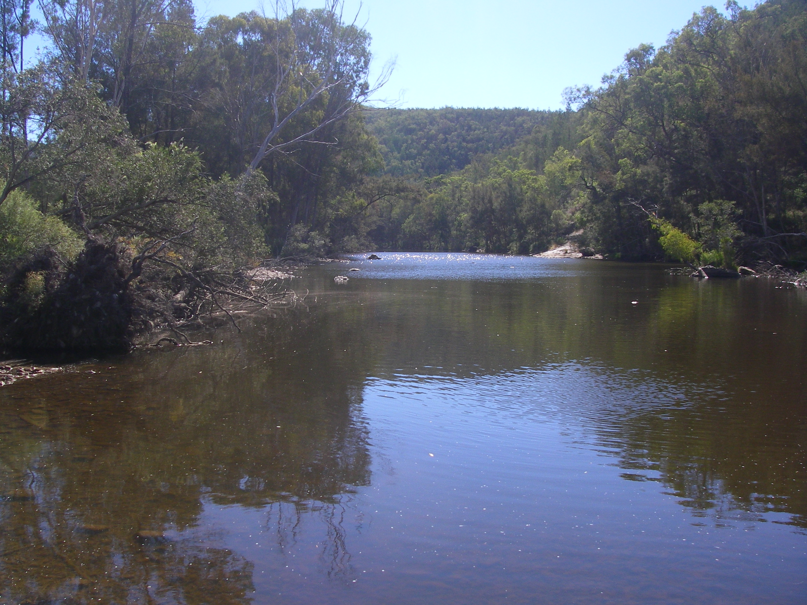
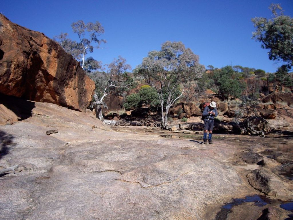
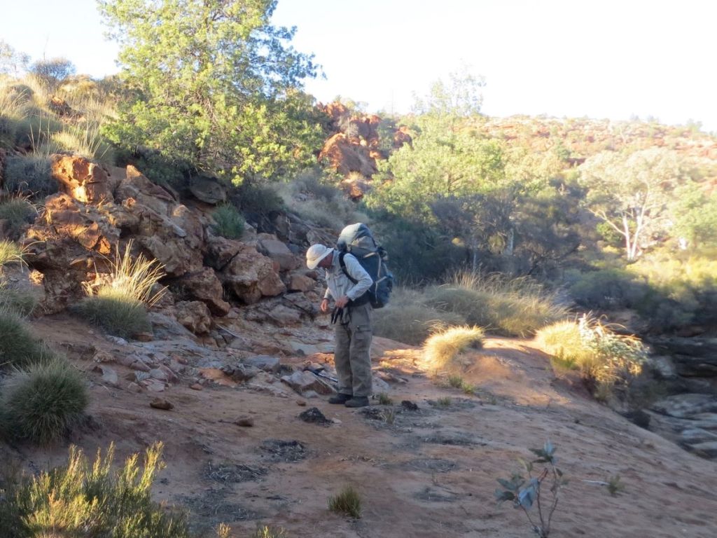
Today’s walk was through a spectacular part of the Mawson Plateau, Granite Plateau Creek. We inched down its deeply incised gorge with numerous dry waterfalls, deep cold pools lined with River Red Gums and picturesque sandy beaches. Our Yudnamutana 1:50,000 map sheet notated this section of the creek as having: ‘Numerous Rockholes‘.

Typical waterhole. Mawson Plateau.
Typical waterhole in Granite Plateau Creek

An understatement. Our downstream progress dropped to a mere five kilometres for a full day’s walking as we negotiated the innumerable waterfalls, deep waterholes, slippery rocks and gorge walls. By my calculations we were averaging about half a kilometre an hour. One of the few trip reports I later unearthed on Granite Plateau Gorge also recounted excruciatingly slow progress.

But it was well worth the effort. The gorge was superb. One never tired of the waterfalls and rock pools even though they were more often than not an obstruction. At the top of each waterfall we would survey the the route ahead and conclude it wasn’t possible to scramble down safely. Frustrating. Instead we would scrabble up onto the open ridges of granite sheets above us and then work our way around and back down into Granite Plateau Creek. This process added hours to our travel time and heavy rucksacks didn’t help. Where was my length of climbing tape when we needed it?

The rock pools were etched deeply into a pink granite bedrock, the water retained by its impermeable granite base. Each pool guarded by jumbles of huge boulders and dry waterfalls. The granite, glass-like, highly polished, smoothed by eons of grit and running water. The polished surfaces were objects of great beauty but it was wise to be attentive when scrabbling near the lip of any waterfalls. The granite surfaces were covered by loose grus – small angular fragments of disintegrated granite common in arid and semi-arid environments. These had a disconcerting tendency to skid underfoot when crossing the granite pavements. We were a long, long way from any help. I was told that the nearest rescue helicopter was 500 kilometres away in Adelaide.

John wending his way over the granite pavement in Granite Plateau Creek. Mawson Plateau.
John wending his way over granite pavements in Granite Plateau Creek: Mawson Plateau.

At the downstream end of the plunge pools were massive banks of sand, idyllic and beach-like. Often shaded by the bleached, white trunks of gnarly River Red Gums. Ideal locations for a lunch stops and camp sites. In retrospect, I would have gratefully spent a few extra few nights coming through this gorge section and spending the afternoons exploring the plateau above the cliff lines.

It was at one of these pools that we finally caught up with our friends. They had already eaten and had a refreshing (read: freezing) dip; but the water was far too cold for three sub-tropical Queenslanders. During the break concern was expressed at our slow progress and that we may not reach our exit point for another two to two and a half days. Then followed more discussion about our situation and the suggestion of setting off the PLB and having Susan extracted by helicopter. A big over-reaction I thought, as did Susan and John. Susan was coping, albeit slowly and cautiously. The decision was left to Susan who said that she was able make it out as long as she took things carefully.

We parted company again with our friends, who promised to wait for us at a suitable downstream campsite. Good as their word, they were bunkered down in a beautiful sandy and level campsite. (GR: 512696 Yudnamutana 1:50,000 AGD 84). We scampered in a tad before darkness closed over the deep gorge. An excellent choice. Heaps of room, plenty of firewood and a water supply just a short walk away. How good is this hiking life? For a third night we settled around a campfire and chewed the fat until weary bones finally sent us to our tents.

Wednesday: Camp Three in Granite Plateau Creek to final base camp near The John Waterhole: 15 kms.
Map of section of Granite Plateau Creek on Mawson Plateau.
My annotations of our route on my Yudnamutana 1:50,000 map sheet

Out again in pre-dawn light to jig up the campfire and boil the billy. My breakfast pickings were pretty meagre as I decided to eke out the rations just in case our exit took two more days. Our threesome were underway by 7.30 am but progress was promptly blocked some 100 metres downstream.

A difficult, long bypass, up and around, taking well over an hour. Not an encouraging start to the day. A bit deflating, in fact. John suggested that we could speed up our progress by climbing up onto the open granite plateau to our east (marked on the map as Numerous Exposed Rocks) and walking to the north east to avoid the worst of the creek’s obstructions. The plan was shelved when we had a good look at the terrain above the gorge and decided that the lack of obvious landmarks on this dry, featureless surface would make for difficult navigation. Far safer to continue plugging our way downstream, come what may.

Although we didn’t realise it at the time, we had just bypassed our last major obstruction. We had unknowingly scored a ‘get out of jail free’ pass. The going got easier with fewer and less complex obstructions. As the gradient eased Susan found the walking much easier and so the pace picked up.

Large chockstones and potholes on Granite Plateau Creek: Mawson Plateau.
Large chockstones and potholes on Granite Plateau Creek. Mawson Plateau.

We pulled up for morning tea under a massive free-standing granite tor, a photo of which I had seen in one of the few trip reports on the Mawson Plateau that I have been able to ferret out. While we lolled in the shade I dragged out our map which showed another belt of ‘Numerous Rockholes‘ ahead, which was a bit disconcerting. Perhaps the estimation of another two days to our collection point was, indeed, close to the mark? Our navigation made problematic by the fact of our collection point being off the current map sheet. The next map sheet over was a 1:250,000, which we didn’t have. As a precaution, I had annotated my ‘Yudnamutana‘ map margin with the vague instructions from one of the SA bushwalkers: ‘campsite at least 3 kms further downstream‘, look for Mt Shanahan near junction with Hamilton R’, ‘ ruins of stone hut on W bank‘. None of this was very reassuring.

Granite tor in Granite Plateau Creek. Mawson Plateau.
Large granite tor on the bed of Granite Plateau Creek : Mawson Plateau.

Our final belt of ‘Numerous Rockholes’ proved a fizzer. Instead we were treated to some of the best arid landscape gorge walking that I have ever done. A sandy creek bed, pools shaded by arching River red gums and red rocky cliffs lifting to the deep blue outback sky. Much more satisfying than creeping down the dark, dank creek lines of coastal Queensland. By our lunch break at 1.00pm we knew the worst of the obstructions were now behind us. It was tempting to take an early mark at one of these magnificent campsites: sandy beaches, abundant water, large shady Eucalypts: no litter and no evidence of the imprint of man. But we were conscious that our slow progress would be a considerable worry to the rest of the party and so we decided to plug on until 4.30 pm . Another long day of nine hours on the hoof.

Campsites in Granite Plateau Creek. Mawson Plateau.
Excellent campsites on sandy beaches in Granite Plateau Creek: Mawson Plateau.

From here the gorge walls dropped away, the sandy creek bed meandered in long loops, allowing us to save time by cutting corners, traversing over low stony ridge lines instead of humping our rucksacks up and down steep rock faces.

By mid afternoon we had lost our position on the map, foxed by the numerous unmarked tributaries, the tortuous meandering of the creek and the sameness of the elevated points above us. No particular landmarks stood out and while our average speed was faster than previous days, any estimate of distance travelled downstream was a rough guess at best. We were reasonably certain that we had moved off the ‘Yudnamatana’ mapsheet and were now effectively mapless. Also GPSless . .

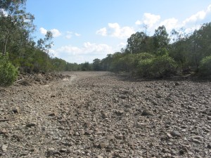
Soon after 4.00 pm we popped out onto a large braided creek junction. For a while we had been expecting to see Mt Shanahan as a guide to our position relative to the Hamilton River junction. But Mt Shanahan had completely evaded us. Unbelieveable. Was this the Hamilton River junction? We took a punt and decided that it was large enough. A quick check of the direction of flood debris suggested that we turn north. It was now a matter of ploughing on in the main river bed until we found a suitable waterhole to camp at. Alas, no more water, just a dry river bed.

Waterhole on Hamilton River
Waterhole on Hamilton River after a good rainfall season.

A little while later John remarked that he could smell smoke. We wandered on, still getting the occasional whiff of Eucalyptus scented smoke. Then I heard the distant purring of a diesel engine. Station owners?

Our walk was over. Ahead was a bluff and waterhole ( now dry) that we recognised as campsite 5 from our 2016 Camel Expedition. Our friends had arrived mid-afternoon and had set up their tents, got the fire going and the billy boiling.

Hamilton River.
Hamilton River ( now dry) at our exit camp.

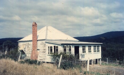
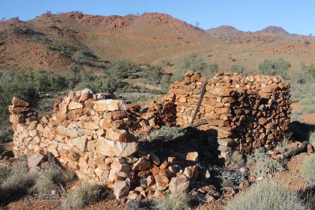
Above the Hamilton River are the ruins of an old hut. The only remains were crumbling dry-stone walls with the brush roof long gone. It may have been built by a shepherd or an old-time miner. Whoever occupied it the decades that followed would have been treated to one of the most picturesque views in the northern Flinders Ranges. Come mid- summer, though, it would have been a hell on earth.

Ruins of shepherd's or miner's hut on Hamilton River. SA.
Ruins of old shepherd’s or miner’s hut on the Hamilton River. Waterhole nearby.

My thanks to John and Susan for the road trip into Arkaroola via Camerons Corner and the Strzelecki Track. A big thanks also to our very generous South Australian bushwalking hosts, especially Cathy and Peter for the trip back to Adelaide and for putting me up overnight in their very comfortable home.

Other gorge walks that may interest you:

Northern Sundown National Park.

By Glenn Burns

 With the Easter long weekend closing in, I wasn’t surprised when my bushwalking friend Brian appeared at the front door clutching one of his well-used topo maps and muttering about “getting away from the crowds over Easter.” Here’s a thing about Brian. He’s a map-man of the old school. There’s nothing much he likes better than to spread out a map, trace a finger along ridge and river and, hey presto a walk is born. Strangely though, I have rarely seen him brandishing a compass and never a GPS.

Photo Gallery

As more and more wilderness areas fall to incursions of the Great Walk track builders, ‘tell-all’ guidebooks and those viral GPS track logs, it is becoming increasingly difficult to find a throughwalk that still has some tantalising unknowns. But I can always rely on Brian to trawl through his map cupboard and come up with something decent; in this case an “exploratory” into northern Sundown National Park, south-west of Stanthorpe. Some say that the name Sundown is said to come from the idea that its valleys are so deep that it’s always ‘Sundown’. Others claim that the name is in keeping with the tradition of using astronomical place names in the area, but I couldn’t find much evidence for this interpretation, apart from references to Comet Creek, Comet Mine, and Arcturus Mine.

Map of Northern Sundown National Park. Qld.
Map of Nth Sundown NP

Sundown offers a terrain of deeply incised creeks, gorges, waterfalls and steep stony ridges rising to over 1000 metres on the Roberts Range. As well, it has an interesting cultural heritage of aboriginal occupation, pastoralism and later on, mining. Brian had nutted out a 54 kilometre walk that had some navigational problems and, not unexpectedly, there was the obligatory physical challenge. It would also give us some respite from camping near raucous Easter 4WDers and was remote enough to be off the radar for most of the latter-day bushwalking fraternity.

Reedy Waterhole Campsite. Sundown National Park.
4WD campsite at the Reedy Waterhole

Although only thirty kilometres from the well known Girraween National Park as the crow flies, the 12910 hectare Sundown National Park has little in common with the benign rounded tor landscapes of the Stanthorpe Granites. Early settlers described Sundown’s rugged and rocky terrain as “traprock”, geologically incorrect, but a good descriptor all the same. Traprock is a term originally applied to basalt landscapes in the UK, while Sundown’s lithology is predominately sedimentary which has been partially altered by heat and pressure to form metasediments. What it does share with Girraween is its propensity for cold weather. This is Queensland’s coldest district; eight months have temperatures below o°C, with -10.6C° the lowest. Fortunately the average minimum for April is a comfortable 9.5C°.

The Severn River, named after the Severn River in England, has incised deeply into the traprock and its course is lined with numerous deep permanent waterholes, many bordered by vertical red clifflines. No danger of going thirsty here even though the park lies predominately on the western side of The Great Dividing Range. In fact, at the end of the wettest Queensland summer in 40 years the park ranger reported to Brian that the Severn was still in moderate spate and we could expect piles of flood debris.

Severn River. Sundown National Park.
One of many river crossings on the Severn River.
Friday : Sundown Homestead site to Severn River via Mt Lofty: 10 kms.

My fellow walkers assembled at the old Sundown Homestead site soon after 1.00 pm, in warm humid conditions.

Old Sundown Homestead. Sundown National Park. Qld.
Old Sundown Homestead.

Our party was eight in total: Brian (leader), Malcolm and Jenny, Bernard (an uber-fit septuagenarian), Russell (aka Starkie) Leanda, and my fellow ailurophile, Richard. Our immediate task was to sweat up the 260m, three kilometre climb to Mt Lofty, a long whaleback feature topping out at 1067 metres. Mt Lofty is said to have been named thus as it was the highest point on the road leading to the Sundown Mine, hence it was “Lofty”. Naturally the Law of Diminishing Returns always applies and our efforts ended in an obscure and thickly vegetated summit. View factor: pretty average, though a vast improvement on Brian’s infamous Kerries whiteout . But this didn’t stop Brian bagging it as one of his 1000 metre peaks, celebrating its capture with a wee dram of someone’s hootch.

View from Mt Lofty. Sundown National Park. Qld.
View from Mt Lofty. 1067 metres.

Then came the descent to the Severn River; a long, roller-coasting two kilometre fire trail that rode up and down over a series of hillocks, ever decreasing in height down to the river at 600m. In fading light a meandering 4WD track carted us off towards our picturesque overnight campsite at Lowe’s Waterhole: an open grassy clearing complete with its own melancholic collection of decrepit yards, a tottering corrugated iron shack and ancient barbed wire fencing. Lowe’s Waterhole was named for a local selector but it is also called Koinas Tanks, which doesn’t always appear on maps. Koina was a Stanthorpe plumber.

Corrugated iron shed at Lowes Waterhole.

These were relicts of bygone times when Sundown was a pastoral run. It was part of the much larger Mingoola, Nundubbermere and Ballandean Stations, all surviving as parish names on our topographic map, as well as Nundubbermere Falls and Mingoola Trig. These three holdings were subdivided into smaller leasehold blocks in the late 1800’s and some of the newly created Sundown Run was cleared for fine wool production; hence our grassy campsite glade.

Back in the 1840’s these holdings were at the far flung reaches of the Empire; conditions for the shepherds could be spartan, violent and unpredictable. On nearby Pikedale Station when Chinese shepherds struck for higher wages, the manager was one Mr H. B. Fitz… said to be called Murdering Fitz. Fitz punched the spokesman and killed him with one blow. Fitz surrendered to a magistrate but as there were no white witnesses he was soon released. He is also said to have fed poisoned flour to the Chinese when their annual payments were due.

Meanwhile back in the 21st century our seven tents soon scattered through a lightly forested grove of cypress pines. We were perched on a low bluff overlooking the Severn where it plunged through a rocky choke; occasional camp noises drifted over the roar of the water from the 4WD camp on the northern bank. Secure in our isolation we settled in around the campfire. Above, the clear sky showed the Milky Way to perfection and such was the clarity that I could easily pick out the dark patches of the Coal Sacks and the misty smudges of the Magellanic Clouds.

Campsite at Lowes Waterhole.
Saturday : Lowe’s Waterhole to Campsite 2: 11 kms.

Today we would track the river westerly past the junction to Nundubbermere Falls and then on a long six kilometre run to the south, stopping somewhere, as yet undetermined, but just short of Reedy Waterhole where quadzillions of 4WDers would be lurking; a veritable village of camper trailers and safari tents even though access to Reedy and Burrows Waterholes is little better than a glorified goat track. But locals call it the “Sundown Road”.

Perhaps our modern adventurers gliding along in their all-terrain wagons could spare a thought for Sydney Skertchly, a government geologist who visited Sundown in 1897. He wrote:

“ …we had horrible weather, fog, and rain, and though we stayed a day after we had eaten our last bit of food… we were obliged to return to Ballandean, as the rain showed no sign of abating. My horse drowned himself in a waterhole and one of our men had to be sent back ill…yet I never enjoyed myself more. I shall long remember our last night. Four of us had dined of less than half-a-loaf of bread and we sat around the camp fire sipping second-hand tea, while a stockman recited Gordon’s poems as a substitute for supper.”

As for our little band of wanderers, our river outing, although not as extreme, would turn out to be a tad damp, for, as the Ranger had predicted, the river was flowing strongly over a succession of rock bars, chokes and rapids. Nary a sandy beach in sight.

Speaking of survival, several shots from a .22 rifle rang out from the far bank; I glanced around at my companions; business as usual, not a whisker twitched. Men of Steel. Across the river our weekend warriors probably thought they could bag one of the wild deer that roam the park, but failing that, there are plenty of other ferals to choose from: goats, pigs, foxes, rabbits, hares and moggies. Good riddens many would say, although one of our fellow walkers had to be weaned off a lingering attachment to “cute little deers”. Still I didn’t have heart to mention that the Parks Service conducts regular culls of deer and such like; a recent tally being 190 deer, 580 goats, 8 pigs and 5 foxes.

8.00 am found us skirting along the bluffs that paralleled the river, just upstream of the Nundubbermere Creek Junction. But with steep ridgelines and cliffs dipping into the river ahead it was pretty obvious that we would need to cross; a pattern of travel that was repeated with monotonous regularity of most of the day. Distance elapsed: a fraction under one kilometre from camp. This was shaping up to be one excruciatingly slow walk.

But slow is good. A chance to potter along, immersed in the ever changing riverscape: long stretches of pool and riffle, interspersed with short runs of rock and rapids; the riverine forests of she-oak, river red gums, tea-tree and bottle brush; skinks basking; and pied cormorants perched on logs, wings outstretched.

Looking downstream from Lowes Waterhole. Sundown Natioal Park. Qld.
Looking downstream from near Lowes Waterhole.

Back on the Severn, we continued picking our way along the bluff scanning for a likely crossing point; a nice dry rocky bar would do me just fine. Brian, who gets impatient with this sort of “fraffing around,” finally blew a gasket, pulled over and announced: “We’re crossing here.” Here, was a line of rapids shooting over a waterfall; a particularly boisterous section of the river if I may say so. Bernard and I, wily old veterans of Brian’s many anti-fraffing campaigns, held back while our safe egress across to the other bank was secured. Safe being a relative term, but apparently a too-short length of climbing tape, no anchor points, slimy rocks, unwieldy packs, racing water and three burly blokes made it ok. And it was.

In the river bed far ahead I could make out a solitary female figure of ample frame draped decorously over a boulder; this could only be the generously proportioned Mma Precious Ramotswe, proprietor of the Number One Detective Agency. On closer inspection we revised this to merely a lady scoutmaster who had just released a gaggle of teenage girls, now straggling off into the wild. Grossly under prepared as it turned out, but it is difficult to be overly critical when the girls were out there having a go.

We caught up with the girls soon enough having retrieved one of their cast-offs… Dad’s favourite hike tent. These kids deserved better than to be let loose with ill-fitting day packs trailing an assortment of tents, tarps and those back-breaking blue sleeping mats, known by my sons as“portable concrete”.

Here is the conundrum for all youth leaders. That fine balance between risk aversion and engendering a sense of competence and adventure. The girls had no PLB and were relying on a UHF radio which was, as they soon discovered, pretty much useless in this rugged hilly terrain. But, still, we impressed to see them out there on a fairly challenging walk and, as it turned out, succeeding.

Back on the river we worked our way downstream clocking up a fraction over one kilometre an hour. With numerous crossings and water occasionally lapping at the sporrans of the resident short-arses we quickly got over trying to keep boots and socks dry and took to the water, just like the wood ducks we kept flushing up ahead of us. As for our three Kiwi tramping companions, all this river walking brought on a nostalgia for things they thought they had left behind in The Land of the Long Black Cloud: wet boots, soppy socks and grossed-up wrinkly feet. Late in the afternoon, much later than expected, we called it a day and set up our tents at campsite 2, a dank grove on the western bank located between Red Rock Waterhole and Rudders Waterhole, having travelled a paltry 11 kilometres for the day.

Pack lowering. Severn River.
Frequent pack lowering.
Sunday : Campsite 2 to Pump Waterhole 1.5 kms.

As the sky lightened I woke to a muted thumping outside my tent. Two chocolate eggs in terminal meltdown were stacked neatly outside my tent flap. Richard claimed that it was just Starkie pretending to be the Easter Bunny, but you and I know better. Fortified by a breakfast of porridge and two chocolate eggs sluiced down with lukewarm coffee, I took off on the short hop to Pump Waterhole, our campsite for the next two nights. Our first task was to find a largish, flat, grassy area.

Malcolm and Brian gamely tackled yet another river crossing, foxed up a campsite on the other bank and came back with sly grins and glowing reports of our new home. But truth will out; a poxy campsite at best… if I were feeling generous in my praise, which I wasn’t. This previously grassy river flat that had been flood-scoured leaving trails of rounded river boulders and debris piles of uprooted she-oaks. Tent sites were in short supply and so pitching our tents required some serious high order spatial sequencing. Docking first was Bernard’s Barnum and Bailey big-top sporting a quarter hectare footprint; next came Malcolm and Jenny’s canary yellow stately pleasure dome and finally the swarm of one-maners came to rest, wherever. In the cool of late afternoon and when seen in the lengthening shadows, our quiet little campsite grew on me, but more of that later. I believe the name Pump Waterhole may have derived from its use as a source of water for mining or for watering stock. There are precedents for this as the Beehive Mine, for example, used a steam pump to lift water 152 metres from a dam on Red Rock Creek.

Severn River. Sundown National Park. Qld.
More river crossings.

After a brief respite, Brian had determined that there would be no skiving off on his watch and directed this slack and idle crew to venture forth and use their R&R time in something productive; like, say, a three or four kilometre walk to the Rats Castle via Reedy Waterhole Campsite. Reedy was pretty much as expected: a good place to avoid over Easter. Nearby is the much larger Burrows Waterhole campsite which was named after Fredrick James Burrows, a WW1 veteran who suicided in 1934 and his grave is said to be on the northern side of the river, but I didn’t tell Brian that. He is overly fond of chasing down stuff like that.

And so it was onward to the Rats… or should have been, except for the dumb-cluck navigators. Both Brian and I had been to the Rats before but now we were approaching from a different direction. Our walk this time went awry when the combined efforts of Richard’s GPS, my map and compass skills and Brian’s usually intuitive bump of locality all conspired to direct us down a shady beckoning track and place us on the wrong ridgeline.

View from Rats Castle. Severn River. Sundown National Park. Qld.
View from Rats Castle looking upstream

Rats Castle was tantalizingly close, a mere kilometre as the crow flies but could have been on the Moon as it was now 1.00 pm our final turn-around time. So we propped where we were, savoured our lunch in a cool woodland of white cypress pines perched high above the Severn River valley. Rats is an interesting geological feature and major landmark on the Severn. It is a ridge of hard fine-grained granite which has intruded into the surrounding metasediments of the Texas Beds, weakened during a major fracturing in the Severn River Fracture Zone. Technically it is a dyke, a vertical intrusion. Early shepherds called it Rats Castle because when it was first seen it was home to small rock wallabies, then commonly called rats. Retracing footsteps we came to the cleared paddock we had walked through several hours previously but this time stopped to enjoy panoramic views across to Mt Lofty but more importantly Red Rock Falls, tomorrow’s objective. We could even see the ridgeline that we would follow up in the morning.

Sundown National Park. Qld.
Heading back to campsite at Pump waterhole

On our return to Pump Waterhole, things were on the up and up. A Sea World style slippery-dip swim, copious supplies of firewood, a now shaded campsite and a good feed and all was well in the circus. For me at least, but not for a forlorn clutch of teenage girls, weary and sunburnt, who limped through in the fading light; one in tears. Uncle Brian took pity, showed them where they were on the map; reassured them that they were getting close to civilisation and their pick-up point and gently packed them off downstream. As I watched their little dejected backs disappear over the promontory of rock near our tents it suddenly occurred to me that I was looking at a Rats Castle look-a-like. Closer inspection revealed it was indeed a granitic dyke intruded through the local traprock. Under our noses the whole time; how could that be? I, too, could have wept.

Monday : Pump Waterhole to Red Rock Falls: 7 kms.

An uphill sort of day; but the weather was kind, cool with light winds. Just as well for we faced a slow grind out of the Severn River Valley by way of a succession of high points: 731m, 828m, 995m, 1027m and finally reaching the high tops at 1032m, an altitude gain of 700 metres. No nav stuff-ups allowed; Richard and I were on the yellow card. But we weren’t taking any chances with today’s route and this time had fed a truck load of waypoints into the GPS just in case the old map and compass led us astray, again. Morning tea was on an open bald, reminiscent of the Bunya Mountains, but just an old cleared grazing paddock, but with superb views across to Mt Lofty and Red Rock Falls.

Roberts Range. Sundown National Park. Qld.
View back to the tops of Roberts Range

 Our morning’s walk would traverse the Sundown Resources Reserve, a reminder of Sundown’s mining past. The mineral deposits formed where the Ruby Creek Granites contacted the overlying traprock (Texas Beds) or are found in fractures above the granite intrusion. Here there are occurrences of molybdenite, tungsten, copper, arsenic and tin, in fact the first deposit of tin in Australia was found on the Nundubbermere Run in 1854.

The Sundown Tin Mine opened in 1893 and operated until 1923 when it closed only to re-open in 1953 until 1956. It was by far the biggest lode producer in the area but other mines were Carpenters Gully, The Orient, and Beehive. Copper sulphides were worked at The Sundown Copper Mine and nearby Comet Mine. Arsenic was extracted in the early 1900s at Beecroft, Sundown Copper and The Orient mines.

Beecroft Mine. Sundown Resources Reserve. Qld.
Beecroft Mine

 Arsenic was an important constituent in prickly pear poison, cattle dips and a hardener for the lead in bullets. Unfortunately arsenic oxide treatment has contaminated Little Sundown Creek and I have read that walkers are advised not to drink the water in Little Sundown below the mines. Fortunately small lodes, lack of water and poor access makes any further exploitation of the reserve unlikely.

After a climb of 700m over 5.5 kilometres we reached the high range country and were about to re-enter the national park. The Queensland-New South Wales border was a mere 1.5 kilometres to our south and with the lunch worms gnawing we steered to a small shady dam. Replete we shuffled off to set up camp on Red Rock Creek, one kilometre upstream from Red Rock Falls. We had left the drier woodlands and vine scrubs far behind and our small tent city now snuggled under a tall Eucalypt Forest of yellow box, brown box and Tenterfield woolybutt . The climatic conditions at 1000 metres being cooler and moister, are conducive to the growth of this taller forest.

Red Rock Falls are etched into the Ruby Creek Granites and drop vertically a massive 150 metres. Scary. But not to Bernard who teetered, camera in hand, along the rim banging off shot after shot. I decided it was better not to watch his impending demise.

Above Red Rock Falls. Sundown National Park. Qld.
The lip of Red Rock Falls

But look I did, elsewhere… scanning the precipitous clifflines for tell-tale white stains that would signal the presence of Peregine Falcons as promised in the Parks brochure. None, neither seen nor heard. So I turned my attention to the views down Red Rock Gorge to its junction with the Severn; in fact it meets the Severn very close to our campsite of Saturday night. In the far distance, at ten kilometres to our north west was Jibbinbar Mountain (975m), our sister outcrop of Ruby Creek Granite and also the site of a government arsenic plant in the 1920s. Ruby Creek, the location for the origin descriptor of the granite that bears its name is found on the New England Tableland, close to Gibraltar Range National Park.

Red Rock Falls. Sundown National Park. Qld.
Looking down on Red Rock Falls

After more goofing around, we took our leave and clambered up to the tourist lookout above, and did touristy things…. more photos, admired the views anew and read the park info board about Sundown’s mining past and then it was off for our final night out on the track and hopefully a decent feed consisting of more than half-a-loaf of bread and second hand tea.

Tuesday : Red Rock Creek Campsite to Sundown Homestead site: 5 kms:

An easy morning’s downhill canter took us into the old Sundown site, sooner than we thought. By 10.00 am it was all over but the shouting… at Richard’s rascally Land Rover Defender if it refused to start. But it did and within the hour we dismounted at the Stanthorpe Bakery for some substantial victuals:a pie or two, spinach and fetta rolls, vanilla slices, cream buns and such like, all washed down with mugs of delicious hot coffee. Eat your heart out Mr Sydney Skertchly.

Sunset at Sundown. Southern Sundown National Park. Qld.

By Glenn Burns

The following account is of a three day bushwalking circuit that I did with two friends in southern Sundown National Park in which we followed up McAllisters Ck, a deeply incised tributary of the Severn River. From McAllisters we ascended  onto the Roberts Range at about 900 metres. After a long hot walk along the high Roberts Range we turned  westwards pushing through dense undergrowth to overnight on Mt Donaldson at 1038 metres. The following day we descended back into the Severn River.

In early October, walking friends Frank Truscott, Don Bell and I completed a three day bushwalking circuit in Sundown National Park taking in some very interesting and challenging landscapes on the way. Although only thirty kilometres from Girraween as the crow flies, Sundown has little in common with the benign rounded tor  landscapes of the Stanthorpe Granites.

Rugged Sundown Landscape

Sundown offers a terrain of deeply incised creeks, gorges, waterfalls and steep stony ridges rising to 1000 metres. It is an inhospitable environment, dry and rocky. To me, a landscape reminiscent of the MacDonnell Ranges of Central Australia. Early settlers described it as “traprock”, geologically incorrect but an apt descriptor all the same. Traprock is a term applied to basalt landscapes in the UK while Sundown’s surface geology is predominately sedimentary which has been  altered by heat and pressure (termed: metasedimentary).

Photo Gallery

Our trip followed an anticlockwise circuit: from the Broadwater up the gorge-like McAllister’s Creek, to Split Rock Falls; a climb to the Roberts Range at 800 to 1000 metres; a major scrub bash to Mt Donaldson (1038 metres); a steep descent to Mount Donaldson Creek and the spectacular Donaldson Creek Falls and a return down the boulder choked Severn River to the Broadwater Campground.

Sundown National Park

Link to another of my Sundown Walks:

Sundown is a remote and rugged National Park a mere thirty kilometre stone’s throw to the south-west of Queensland’s very popular Girraween National Park. My bushwalking friend Brian and I have, over the years, traipsed many a kilometre along the Severn River in Sundown. This is an account of one of our many expeditions in Sundown.

Geology of Sundown National Park

Sundown’s stony terrain had its origins in the Carboniferous Period (360million – 286 million years ago). Sediments from a volcanic mountain chain on the eastern edge of the Gondwana continent were deposited on the continental shelf and later avalanched onto the deep ocean floor. The sediments formed thick beds of sands, silts and mud. Compression and deformation of the beds resulted in the metasediments of the Texas Beds. The predominate rock types of the Texas Beds are Argillite and Greywacke. Argillite is a dark grey/black mudstone, very fine grained and extremely hard. Greywacke is a coarse grained sedimentary of mixed composition, also very hard. These were later uplifted to a mountain chain, the remnants of which form the tilted hilly ridges of Sundown.

DAY ONE
McAllister Creek Gorge

We left Broadwater mid afternoon and rock hopped up McAllister Creek to Split Rock Falls. Here the creek was deeply entrenched in a narrow red gorge, defying Frank’s GPS to find the requisite number of satellites. Following Don’s confident lead we hung from cracks and crevices, teetered along dubious ledges, finally reaching the barely trickling “split” falls, impassable…. of course. Our bypass was a steep scrabbly climb on the spine of a rocky ridge to our campsite in a cypress pine grove at 800metres. One of the very few open areas in an otherwise very stony terrain. At 6.30pm, on sunset, we downed packs and settled into our campsite, complete with its own comfortable log seats and frug of whining mosquitoes. I soon lost my desire to join the “sleep under the stars” contingent as a full moon rose and the mosquitoes settled in for the duration. Instead I retired in comfort to my insect/moonlight proof “Taj Mahal”.

McAllister Ck Gorge
McAllister Ck Gorge

DAY TWO
Roberts Range

Our traverse along the crest of Roberts Range on the second day followed one of the ancient ridges. The Roberts Range was a roller coaster of elevation gains followed by steep descents. Hot work. Incredibly, we found two small dams high up in the catchment where we could replenish our water supplies and wash. Mid afternoon we swung off the Roberts Range heading for Donaldson.

4WD track on crest of Roberts Range

Mt Donaldson

Progress faltered to about one kilometre an hour and visibility fell to ten metres as we pushed through unpleasantly dense thickets of Peach Bush (Ehretia membranifolia) and Cough Bush (Cassinia laevis). On occasion, one of our trio would disappear into a thicket failing to re-emerge after an appropriate wait. Several cooees usually provided the necessary geographic re-orientation and a bleeding bruised body would come flailing through the undergrowth, in due course.

Rough going near Mt Donaldson

On the summit of Mt Donaldson on our second evening we found some younger Permian breccias on top of the Texas beds. Breccias are sedimentaries composed of coarse, angular fragments of older rocks. My guide book implied fossil shellfish aplenty these outcrops. Even Blind Freddy should find one. The breccias were obvious enough but the fossils weren’t. Unfortunately, my conscience wouldn’t allow me to shatter rocks to find them, tempting though the prospect was.

As the sun set we perched on rocky benches above the cliffline and took in the view. This is reputed to be the best vantage point in the park, not an exaggerated claim. A rugged landscape unfolded: Donaldson’s northern summit was fringed by massive cliffs; stretching off to the north east was the Razorback (Berchtesgaden on my map) a ridgeline of numerous 900 and 800 metre hills grading down to the Rats Castle (a granitic dyke) on the Severn River, four kilometres away. Immediately below was the Stony Creek valley, lined with numerous scree slopes of shattered boulders. My track notes advised that walkers should not be

tempted to descend Stony Creek since it is strewn with large boulders.”

On a distant western cliffline a trip of goats skittered along a narrow ledge, intent on finding a night bivouac in the thick brush.

DAY THREE

With the Stony Creek warning in mind, we left Mount Donaldson at 5.30am, chased off the summit by gale force winds and a suspiciously thick cloud bank building to our east over Stanthorpe. We descended steeply into Mount Donaldson Creek. Here we rewatered, dropped packs and headed downstream to inspect Donaldson Creek Falls, developed on resistant strata, with its 100m drop towards the Severn River. The views down a red canyon to the Severn did not disappoint. Saddling up again we bypassed the falls and descended 230 vertical metres to the Severn River Flood Plain. The bed of the Severn is confined to the NNE trending Severn River Fracture Zone. It is interesting that the river has not diverted around the harder Texas Beds but has continued to cut down into the resistant metasediments. Consequently, for such an old land surface the sinuosity of meander looping of the Severn is remarkably undeveloped. The sinuosity ratio for the Severn in Sundown is 1.04; very close to the ratio for straight, younger streams such as the Johnstone River (North Queensland) which has a ratio of 1.00. A stream channel on a flat flood plain will often have a ratio of 3.00 or more (technically described as tortuous). Still, this was all useless palaver as we hoofed the final six long hot steamy kilometres along a rough bouldery river bed to our final destination at Broadwater.

My thanks to Frank and Don for their invitation to join them on the Sundown  trip and for some great navigation and geology

References:

Willmott, W, 2004:   Rocks and Landscapes of the National Parks of Southern Queensland.

Mapsheets:

  Sundown National Park   1:50,000 ( Hema Maps)

Mount Donaldson   1:25,000

Mingoola   1:25,000


Sundown National Park

By Glenn Burns

Sundown is a remote and rugged National Park a mere thirty kilometre stone’s throw to the south-west of Queensland’s very popular Girraween National Park. My bushwalking friend Brian and I have, over the years, traipsed many a kilometre along the Severn River in Sundown. This is an account of one of our many expeditions in Sundown. 

Brian, ever the expedition genie, had again conjured up yet another ‘exploratory’ trip covering central and northern Sundown. This time we would venture  high up onto the Roberts Range which marks the southern boundary of Sundown and forms the state border between Queensland and New South Wales. The only fly in the ointment was our intended access to the Roberts Range, over Mt Donaldson. Those who have tramped this way before will recall the swathes of dense undergrowth with a certain sense of trepidation.

The Severn River: Sundown National Park

Sundown is said have been given its name by old bushmen who thought that its valleys were so deep that it was always ‘sundown’. It is a spectacular landscape. Named after the Severn River in England, this deeply incised antipodean Severn, with its waterholes, cool side gorges and waterfalls makes for relatively benign walking. But away from the river, Sundown can be inhospitable. Dry, stony ridges rise to well over 1000 metres, the so-called ‘traprock’ country. The highest hills are invariably smothered in tangled thickets of Peach Bush, Cough Bush, Hop Bush and other shrubby pleasures like the prickly Dead Finish: all right up there in nuisance value with wait-a-while and lantana.

View from Mt Donaldson overlooking The Razorback

The lure for me in all this was that we would be following the old Roberts Range border survey line set out in 1863 by Francis Edward Roberts, Queensland Government Surveyor and Isaiah Rowland, Robert’s counterpart from New South Wales. Although Brian and I had walked a small section to the south-west several years ago, we could now complete another leg over the highest part connecting Mt Donaldson and the old Sundown homestead site. My fellow expeditioners, experienced throughwalkers all, were quick to sign up to four days of the rumoured slacking down the Severn, early finishes, superb high range campsites and heaps of firewood for our evening fires. Buyer Beware.

Photo Gallery: Sundown National Park

Wednesday 25 April: Sundown Homestead site to Red Rock Creek: 5.5 kms.

Eight bushwalkers mustered at the old Sundown Homestead site on a decidedly coolish Granite Belt afternoon: Brian (leader), Alf, Christine, Jenny, Roland, Sally, Samantha and one well rugged-up scribe. Temperatures had dropped to a nippy 14°C as a blustery 40 kph sou’westerly swept in. Hardly unexpected, as this is Queensland’s coldest district, with eight months recording temperatures below 0°C. Sundown’s Park HQ at The Broadwater has recorded a creditable minus 8°C. Fortunately the average minimum for April is a more comfortable 9.5°C.

Walkers @ Rats Castle

But cool was cool for our five and a half kilometre uphill walk in along the old 4WD track to our Red Rock Falls campsite. For those humping in their supplies of birthday cakes, apples, sourdough rye bread, cheeses, a hogshead of red wine and a hundredweight of juicy Kalbar carrots, the track kindly winds its way ever so gently upward, a modest height gain of only 160 metres from the homestead. At the base of Hill 983 (metres) we shrugged off our well-stocked packs for the short walk into Red Rock Falls Lookout.

Source: Glenn Burns

Red Rock Falls & Sundown’s Geology

From the lookout, the full story of Sundown’s geology and topography could be read in the landscape revealed before us. This rugged terrain had its origins in the Devonian-Carboniferous Period some 370 to 290 million years ago. Sediments from a volcanic mountain chain on the eastern edge of the Gondwananan continent were deposited on the continental shelf and later avalanched into deep ocean trenches. Thick beds of sands, silts and mud were compressed, hardened and deformed, producing the very hard metasedimentaries of the Texas beds. In a later episode of mountain building, the metasediments were uplifted, tilted and fractured to form a mountain chain, the remnants of which are the ridges and hills of Sundown. Later, during the Triassic (248 -213 million years ago) a small body of Ruby Creek Granite was intruded into the Texas Beds and now outcrops at Red Rock Gorge and Jibbinbar Mountain to the north, but also triggered major fracturing of the Texas Beds. It was also responsible for the mineralization of the Texas Beds and the formation of Rats Castle, a granitic dyke. For a detailed explanation of the geology of Sundown NP go to Warwick Willmott’s excellent tome: Rocks and Landscape of National Parks of Southern Queensland.

But our immediate attention was drawn towards the now dry Red Rock Falls. As Alf pointedly remarked to our leader:

“The falls aren’t falling, Brian. Can we get a refund?”

By way of compensation, there were panoramic views along the red cliff lines which plunge a good 50 metres to the Red Rock Creek gorge below. In reality the granite cliffs are sandy in colour when freshly broken, but have been stained red by lichens on undisturbed surfaces.

Red Rock Falls: Sundown National Park.

The touristy bit done, we mooched back to retrieve our packs and strode off to our first overnight campsite. A Sundown Hilton. Grassy, level tent sites, plenty of water and ample firewood. After my 5 am start and the tedious drive to Sundown, a Bex and a good lie down beckoned. I had barely thumped in my last tent peg when Brian, whose largesse never extends to free time, rounded up the lethargic and indolent for some late afternoon exercise down Red Rock Creek to peer over the falls.

Campsite on Red Rock Creek

Thankfully the biting sou’westerly gusting up the cliff face quickly dampened any corporate enthusiasm for poking around and the natives were unusually  restless. Brian did manage to steady his now pretty toey charges long enough to point out a brownish smudge on the horizon, which he insisted was the grassy knoll where we would have morning tea on the morrow.

Afternoon stroll down Red Rock Creek

Back at the campsite firewood was scrounged, the fire lit, and cups of soup, tea and coffee brewed. And as the light faded from a sailor’s delight sky, the bush chefs gathered to whip up an epicurean extravaganza. Brian resorted to an old favourite of his, bangers and mash with a side dish of green peas. But for my money, bangers and mash or all those Backcountry Pantry roast lambs and veg didn’t compare with Jenny’s culinary coup, a Scotch Devil. A hard-boiled egg covered with crumbed sausage meat and deep fried. A meal fit for any claymore-wielding Highlander and a kilojoule king-hit capable of propelling Jenny to Jupiter and back.

The Song of Roland

Meal over, we warmed our bottoms over the crackling fire while Roland regaled us with one of his many tall tales, occasionally true. Not Roland and the Midnight Koels’ this time, butClose Encounters of the Dingo Kind’ set in The Valley of Giants, Fraser Island. I recall another of Roland’s dingo dingles in Central Australia when Brian, Bernard, Di Hoopert and I were due to link up with Roland at Furnace Gully near Redbank Gorge on the Larapinta Trail. After two days of cross country travel from Mt Zeil and manyCooees” andRoowlaands” we finally looked down on a disconsolate Roland perched in a baking, bleak and windswept gully, the ultimate Mars landing experience. A black and tan dingo was slowly prowling the perimeter of the campsite, patiently stalking its prey in ever decreasing circles. Back in Sundown it was off to bed for these little puppies, lulled to sleep by friendly frog calls and the distant rush of wind through the trees on the high ridges above.

Thursday 26 April: Red Rock Ck to Burrows Waterhole: 8.5 kms.

5.15 am. Birthday boy Brian was already on the move. The usual clanking of billies and mugs, stirring up the campfire and dispensing cups of tea and coffee to all and sundry. Other bleary-eyed bushwalkers gradually trickled out into a crisp Granite Belt morning, 1°C, grateful for a warming fire. While the others hovered over the fire I waddled off to check out a small mullock heap and mine pit that Brian had found nearby. Sundown was the site of a number of mines producing molybdenite, tungsten, copper, arsenic and tin. In fact, the first tin deposit found in Australia was on the nearby Nundubbermere Run in 1854.

Mining at Sundown

The Sundown Tin Mine opened in 1893 and operated until 1923 when it closed only to re-open in 1953, finally closing in 1956. It was by far the biggest producer in the area but other mines were Carpenters Gully, The Orient, and Beehive. Copper sulphides were worked at The Sundown Copper Mine (1888 to 1908) and nearby Comet Mine. Arsenic was extracted in the early 1900s at Beecroft (1917 to 1927), Sundown Copper (1922 to 1924) and The Orient (1918) mines.

Beecroft Mine
Beecroft Mine

Arsenic was an important constituent in prickly pear poison, cattle dips and a hardener for the lead in bullets. Unfortunately arsenic oxide treatment has contaminated Little Sundown Creek and I have read that walkers are advised not to drink the water in Little Sundown below the mines.

Fortunately small mineral lodes, lack of water and poor access ensured any further exploitation in Sundown Resources Reserve was temporarily off the agenda. But this could all change under any future governments. The Sundown Resources Reserve does not have the same level of protection as its surrounding national park. In fact, during the 1980’s a mineral exploration company had been sniffing around the Severn River Fracture Zone west of the old Sundown mines and discovered bulk low-grade tin. But as Queensland’s former Premier Joh Bjelke-Petersen was apt to say to those pesky greenies, bushwalkers and press hacks:

Now, don’t you worry about that.”

0r the even more confusing:

We’ll come to that bridge when we’ve crossed it.”

By 7.45 am the party rolled out, climbing steadily the 100 metre altitude gain to Hill 1032. Strange, this climbing bit, given that Brian had described today’s route as a ‘downhill day’. Alf, ever the agent provocateur, inquired:

Is this another one of your uphill flat bits, Brian?”

But after Hill 1032 we indeed dropped down a long steepish 4WD track that took us through the Sundown Resources Reserve and finally up onto Hill 731, our morning tea spot, as promised. Sally produced a delicious pineapple cake while I unearthed the ginger cake that Judy had baked for Brian’s birthday bushwalking bash. A round of ‘Happy Birthday, Brian’ echoed through the hills while Brian huffed and puffed and finally blew out his three little candles. We wolfed down great slabs of birthday cake, sat back and took in the views back up to Red Rock Falls, three kilometres hence.

The Birthday Boy
The Birthday Boy

Our final descent of the morning was the 250 metre drop to Pump Waterhole on the Severn. This proved to be slowish work, gingerly picking our way down a steep hillside mantled with loose traprock. On the way down Alf called us over to inspect a pile of bleached bones:

Come and have a look at these bones. Hey, Brian. Are these bushwalkers from your last trip?”

Pump Waterhole probably takes its name from the fact that the Severn River was the source of water pumped up to mines or to stock tanks.

Pump Waterhole
Pump Waterhole

An hour later we ambled into Reedy Waterhole, lunch stop. I always take a wolfish interest in other bushwalkers’ food. Roland’s lunch today, for example, was distinctly continental: crusty sourdough rye bread, substantial slabs of cheese and several of those scrumptious carrots that he had carted in.

Burrows Waterhole Campground

After another half hour of rock hopping and two river crossings we strayed into Burrows Waterhole for an early mark. Brian’s fear that this official campground would be infested with squadrons of 4WDers was unfounded. A 2.30 pm finish. Unprecedented in the annals of Manuelian throughwalking. Burrows, a very large waterhole, was named after Fredrick James Burrows, a WW1 veteran who suicided in 1934 and his grave is said to be on the northern side of the river.

Burrows Waterhole
Burrows Waterhole

A grassy campsite, swims all round and an afternoon of unstructured mooching stretched ahead. Ever the wily coyote, I kept stumm about Fredrick Burrow’s nearby gravesite for fear of whetting Brian’s appetite for local history and back to back afternoon rambles. Anyway, the horses had already bolted. Jenny and Christine drifted off to check out the only other inmates of the campground; Samantha was engrossed in platypus watching; Sally sudokued; Roland brewed coffee, while Brian, predictably, kept himself busy rustling up the firewood and on matters navigational.Sunset came with another red sky, Venus and Mars peeking above the western horizon. The dark and cold folded in around us. So like the dingoes of Central Australia, our little pack crept ever closer to the warmth of a blazing campfire. Brian’s birthday bacchanal cranked up again, fuelled by more portions of birthday cake and washed down with a pannican of Alf’s finest vintage red wine. Or so he claimed. But by seven o’clock party pooping types headed for their snuggly sleeping bags. So off we all tottered. Jenny for her nightly Middlemarch fix, Brian to Agatha Christie, a turgid French novelist for Christine, travel stories for me, Alf to play cards, Sally to Sudoku, and Samantha to catalogue, classify, and coordinate her hiking kit in preparation for an early start tomorrow.

Roland relaxing at Burrows Waterhole

Friday 27 April: Burrows Waterhole to Stony Ck Junction via Rats Castle: 9 kms.

Woken at an ungodly 5 am and not by the instantly recognisable “zzzzip” of Brian’s tent. No, the guilty party was Samantha noisily rummaging around in her tent; re-reorganizing her gear so it was all ship-shape in Bristol fashion. I crawled out. Pitch black. An hour and half later, as first light tinged the eastern sky we luxuriated in the balmy 7°C conditions; the cloud and humidity a harbinger of the predicted rain due on Saturday. Today we were off to Stony Creek junction via Rats Castle. Stony was our jumping off point for the climb to Mt Donaldson and the Roberts Range. Rats Castle is a well known Severn River landmark that had evaded three dumb-cluck navigators on our 2011 Sundown walk. But not this time. We approached our elusive quarry from a ridgeline leading up from Little Sundown Creek and half an hour later we scrambled up onto its jumbled red granite boulders. Legend has it that the boulders of Rats Castle have been dynamited by vandals.

Rats Castle

Rats is an interesting geological feature, a ridge of hard fine-grained Ruby Creek granite which has intruded into the surrounding metasediments of the Texas Beds, weakened during major crustal distortions in the Severn River Fracture Zone. Technically it is a dyke, a vertical intrusion.

View over Severn River from Rats Castle

Early shepherds called it Rats Castle because when first seen, it was home to small rock wallabies, then commonly called rats. The rats were probably the Brush-tailed rock wallaby, Petrogale penicillata, listed as vulnerable and now found only at Nundubbermere Falls despite extensive surveying in Sundown. This shaggy-coated brownish wallaby has great agility on rock faces and can even scale sloping trees using its powerful legs and strong claws. It is nocturnal but cool weather will see it out basking on ledges in the sunshine. Unfortunately, it has been an easy prey for foxes, a target for shooters and the local population suffers from deleterious in-breeding.

For those bold enough to clamber onto the few summit boulders, Rats commanded great views over the Severn, 80 metres below. Ten minutes later eight pack rats were also below, having slithered and skated down over loose scree to the river bed. A smoko break. Here we bade a fond farewell to Roland who was returning to Burrows and like the proverbial penny would reappear two days hence, at Sundown Homestead. For the rest of us it was ever onward, past a herd of goats, past a fat pig and past a succession of waterholes: The Hell Hole, Turtle, Blue, Channel and Wallaby Rocks. Six kilometres, nine river crossings, one dodgy log crossing and we lobbed into our Stony Creek campsite soon after two o’clock.

Innumerable river crossing

Stony Creek Campsite

Another excellent campsite: remote, set on a flat alluvial terrace, grassy tent sites shaded by Sheoaks, Forest Red Gums, Cypress Pines and Rough-Barked Apples, ample firewood and a waterhole nearby. Tents went up quickly as the sky had clouded over and the wind had now swung to the east, rain threatening. With full cloud cover our maximum temperature barely reached a miserable 15°C. In fact, it was the coldest day of the month. But around the warmth of the campfire later in the evening Alf stepped up as raconteur-in-residence and entertained with travel stories from wildest Africa. Well, about as wild as you could expect from an Alf on a swanky safari to various South African diamond mines, gold mines and De Beers HQ. Just as we were being winched deep into the bowels of yet another diamond mine, a light shower of rain cut short our virtual tour and chased us off to our tents. But who would complain? Tucked into a toasty sleeping bag, light rain pattering down and a soporific page or two of James Elliot’s:  A Visit to Kanasankatan.

Packing up on a wet morning

Saturday 28 April: Stony Ck to Roberts Range via Mt Donaldson: 6 kms.

Climbing up to Mt Donaldson

Despite light rain all night we were all packed, kitted out in wet weather gear and gaiters, and ready to make tracks by 7 o’clock. Today would be our most challenging. Off track, pushing through manky vegetation, with a stiff 200 metre climb to Mt Donaldson Falls, then a second 420 metre climb to Mt Donaldson (1036 m) and onwards to Hill 1024 and Hill 1047 before dropping to our campsite on a spur of the Roberts Range at 960 metres.

Mt Donaldson

Initially navigation would be a cinch, merely following an old rabbit or dingo fence for the one kilometre climb to our old 2008 campsite at Mt Donaldson Falls. Light misty showers dogged us all the way along the fence line and the slimy wet traprock slabs in Mt Donaldson Creek were a disincentive for a walk down to the lip of the falls. For those who risked life and limb skating down, the views down the gorge were standard Manuelian: obscured by wreathes of misting rain.

View down Mt Donaldson Ck

Another two and a half kilometres and the 420 metre altitude gain brought us to Mt Donaldson’s western peak. But not before pushing through dense thickets of Peach and Cough Bush; troublesome stuff in that we had left the navigational safety of the rabbit fence and had to resort to the dark arts of map and compass to keep us on the straight and narrow, reaching the summit five and a half hours after leaving our Stony Creek campsite.

The view from Mt Donaldson over The Razorback.

It being 12.30pm we propped for lunch on the exposed summit rocks. My invitation to check out the rocks, Permian breccias, was politely ignored. My geology book claims the breccias are rich in fossil shellfish. Apart from a couple of two-legged ones I have yet to find these fossils. Anyway, my reluctant field assistants were more intent on hunkering down to stay warm and out of the cold blustery easterly wind than scouring the summit for my fossils. I could see showers scudding all around us but, by the grace of the Gods of Weather, we stayed dry.

Hunkering down out of the cold wind.

The summit is reputed to be the best vantage point in the park. And it is, though most of my companions couldn’t be roused from their hypothermic huddling to appreciate the scenery. The vista across Sundown’s rugged landscape was, quite simply, fantastic. Donaldson’s northern fall is marked by massive cliff line which drops 400 metres into Stony Creek. Its valley is lined with numerous scree slopes of shattered boulders. Stretching off to the north-east was the Razorback, marked as Berchtesgaden on my old Hema map. The Razorback, a spur of the Roberts Range, is a five kilometre ridgeline of 900 and 800 metre hills grading down to our old friend, Rats Castle on the Severn.

The afternoon’s traverse, at a mere three kilometres, was another rib-tickling episode taken from Brian’s barrel of bushwalking laughs. I had walked this section on two previous occasions and I knew what was coming. These high western-facing slopes are covered by what botanists describe as shrubby woodlands. The tree layer is a mixture of Tumbledown Red Gum (Eucalyptus dealbata), Caley’s Ironbark (E. caleyi), Youman’s Stringybark (now E. subtilis) and Black Cypress Pine (Callitris endlicheri). So far so good. But the understorey is dominated by dense groves of Peach Bush (Ehretia membranifolia) and Cough Bush (Cassinia laevis). The leaves of Cough Bush or Wild Rosemary were an old bush remedy. They were the active ingredient in a decoction for the treatment of respiratory ailments, hence, Cough Bush. The almost impenetrable groves of the understorey reduced our forward progress to about one kilometre per hour with visibility often less than 10 metres.

This is why we have Brian on the payroll. Not only does he collect firewood, light our fires, act as a sort of campground Tea Lady and reads maps upside down, but he’s also on call for any untoward bush bashing. As Don Burgher, another of Brian’s ancient bushwalking cronies, is fond of telling me:

“Never get between Brian and a patch of Peach Bush,”

or was that a patch of lantana? Or a pot of Toohey’s Old?

A barrell of laughs.
A barrel of laughs.

Never mind, he had done this sort of thing before. We formed up, line astern. A quick compass call and Brian would slowly reverse his rucksack into the thicket, disappearing from view as the Peach Bush wrapped around him. Six walkers then inched forward following the spoor of blood splats, chunks of human tissue and, in deference to the ladies present, muffled curses. Crafty walkers, like Alf and I, brought up the rear, seemingly busy consulting map and compass. And so on, until just before four o’clock when we emerged from the undergrowth onto the small dam where we would camp for the night and lick our wounds. As we prepared to put up our tents, light rain misted across. Impeccable timing. And just when I was having a few doubts about this bushwalking lark, my tent pole snapped.

Campsite high on the Roberts Range.

Sunday 29 April: Campsite to Sundown Homestead via Roberts Range: 11 kms.

Another dampish morning until the mist dissipated leaving a light cloud cover, making for very pleasant walking conditions. Our final day on the track, which would take us seven kilometres along the spine of the Roberts Range. This 1000 metre divide separates the Severn River to the north from its southern neighbour, Tenterfield Creek; both tributaries of the Dumaresq River, named by the explorer Allan Cunningham after the Dumaresq family who were a prominent Australian colonial family. We would be following a well-maintained 4WD track, a fire management trail that parallels the Queensland-New South Wales border fence, technically a Dog Check Fence.

4WD track on spine of Roberts Range

The walk is the classic high range roller-coaster starting at 1067 metres, dipping and rising: 973 m, 1039 m, 1030m, 1015m, 1087m and reaching 1120m at our final climb before turning off and descending to the Sundown Road. Climbing up to our first high point, Hill 1067 we passed into a special habitat, a high altitude forest, restricted to the very highest parts of Sundown and the Granite Belt. This is open forest, dominated by Silvertop Stringybark (Eucalyptus laevopinia), Yellow Box (E. melliodora) and the best name of all, Tenterfield Woollybutt (E. banksii). Silvertop Stringybark and Tenterfield Woollybutt are interesting in that they are disjunct populations of the same species growing further east at Lamington and Mt Barney. It is likely that they survive here on traprock because of the cooler, misty micro-climate on the highest points of the Roberts Range. Further along the range, on the summits of the highest hills at 1087 metres and 1120 metres, we passed through more small patches of high altitude forest.

Roberts Range
Roberts Range

As we climbed to the final high point at 1120 metres we entered a designated ‘essential’ habitat. These are areas meant for the protection of a species that is endangered or vulnerable. In this particular case the species was the Superb Lyrebird (Menura novaehollandiae) neither seen nor heard by our party. The Superb is the King of Karaoke and is such a good mimic that the bird being copied cannot tell the difference. The male Lyrebird has a repertoire of 20-25 other bird songs as well as mimicking car engines, chain saws and even barking dogs.

The Border Survey 1865

When Queensland was proclaimed a separate colony on 6th June 1859, Surveyors Roberts from Queensland and Rowland from New South Wales were sent to define the boundary between Queensland and New South Wales from Point Danger to the Dumaresq River. They started work in 1865 and worked separately using their own instruments. As their traverse lines were different the defined border appeared in different positions. Ultimately the Roberts survey was accepted and this was the line depicted on our map and that we were following today. I was keen to find any relics of their traverses such as rock cairns or horse-shoe blazes on trees. I found one old blaze, indecipherable, so there is no evidence that it was part of the border survey. It would be interesting to do the entire Roberts Range traverse with data from Robert’s original field book.

An old survey blaze
An old survey blaze

Roberts, an Irishman, trained as an engineer and in 1856 he became surveyor of roads for the Moreton Bay District later gaining a post as a surveyor with Queensland’s Surveyor-General’s Department in 1862. Colonial surveyors were tough, capable bushmen able to endure considerable hardship: life under canvas, poor food, heat, flies, arduous travel and isolation. Unsurprisingly, it was a constant struggle to stay healthy. Queensland colonial surveyors could be struck down by any number of health hazards: Barcoo Rot, Bung Blight, Sandy Blight, Dengue Fever, Malaria, snakes and crocs. Francis Roberts escaped all these only to die prematurely of sunstroke in 1867, aged 41.

The Dog Check Fence

Today, the Border is marked by a Dog Check Fence; an outlier of the mighty 5,412 kilometre Dog Fence that runs from Jimbour in Queensland to the Great Australian Bight in South Australia. The Dog Fence is said to be two and a half times the length of the Great Wall of China and is easily visible from space. Our 1.8 metre high Dog Check Fence or Dingo Fence is a relic of an intricate maze of some 48,000 kilometres of interconnecting vermin fences built to keep dingoes and bunnies at bay.

The Dog Check Fence
The Dog Check Fence

Late in the morning we came off the Roberts Range and exited onto the Sundown Road, only four kilometres from our cars at the old Sundown Homestead. At that very moment a piratical black Defender sailed around the corner and hove to. A dark tinted window slowly descended revealing a grinning Cheshire reclining on the back seat. Bold as brass. It was that rapscallion of road and range, our old friend Roland, looking mighty pleased with himself, and why not. He had cadged a ride out from Burrows Waterhole, saving himself a twenty kilometre walk out.

A boarding party of several rucksacks and bushwalkers made for the remaining spare seat but Roland’s Samaritan was having no unwashed bushwalking riff-raff in his vehicle. He brusquely raised the gang plank and drew off, at pace, for the homestead. Roland returned soon after in his own 4WD. But again I missed a berth for the kilometre drive to the homestead site. Resigned to solo finish I plodded on, comforted by thoughts of our traditional bushwalkers’ banquet in Stanthorpe. A beano of bakery delights. Now what would I have ? A fetta and spinach roll or maybe a curry pie? A mug of piping hot chocolate or a flat white? A vanilla slice or cream horn? In my dreams. Our bakery was closed and the alternative café seemed overwhelmed by our orders for a few burgers and coffees. An hour later we exited said eatery, an underwhelming Granite Belt gourmet experience it must be said. Maybe the pub next time for a ten dollar burger and quick beer.