Tag Archives: Bushwalking in South East Queensland

Dingo Days . Hiking K’gari’s Southern Lakes Circuit.

K’gari or Fraser Island, is the world’s largest sand island; a huge sandmass of 166 000 hectares in area and 123 kilometres long by 25 kilometres wide. It is a World Heritage listed landscape of high dunes, pristine freshwater lakes, wallum heathlands, extensive active sandblows, reedy swamps, sandy ocean beaches and towering forests. K’gari attracts nearly 300 000 visitors annually. For the bushwalker it offers an unbeatable combination of relative solitude, brilliant scenery, a great interlocking track network and excellent hikers camps tucked away from the hordes of 4X4 campers and tour buses. Our walk would take us on an 70 km circuit through a landscape of forested high dunes and perched lakes loosely known as the Southern Lakes District.

The traditional owners of K’gari are the Butchulla people who have occupied the island for at least 5000 years. Evidence of their occupation is found in middens, scar trees , lithic scatters and placenames of K’gari’s natural features.

Examples of Lithic Scatters on K’gari

Please leave all artefacts where you find them. Do not remove. Quote from Yolngu elder: ‘It ( sliver of quartz ) must be put back in the earth and left to grow… as all things do, men, animals, everything.’

What’s in the name: K’gari or Fraser Island ?
Repatriation of a name.

K’gari is said to mean ‘paradise’ in the local Butchella language. It is pronounced ‘gurri‘. Fraser Island is named after a Scottish woman , Eliza Fraser, who was shipwrecked on K’gari in 1836. After her rescue she spread damaging and increasingly lurid accounts of her treatment by the Butchella people. Her accounts were syndicated as far as the Americas and reinforced the idea that Indigenous people were savages.

Portrait of Eliza Fraser
Source SLQ: Portrait of Eliza Fraser.
The rescue of Eliza Fraser.
Source SLQ: The rescue of Eliza Fraser.

The reversion to K’gari began in 2011 when the Queensland Labor government added K’gari as an alternative name in the Queensland Place Names Register. In 2017 Fraser Island was renamed to K’gari (Fraser Island) National Park. In 2021 , the World Heritage Committee adopted the name K’gari (Fraser Island) World Heritage Area. I believe that it is the intention to give Aboriginal names to K’gari’s natural features, while man-made features may keep current names.

Historical Photos of Butchella on K’gari.
Man holding boomerang, K'gari
Source SLQ: Man holding boomerang K’gari. ca 1900.
Decorated men with shields & spears 1870.
Source SLQ: Group of decorated men with shields and spears. 1870s. Pierson’s Camp. K’gari.
Man showing scarification.
Source SLQ: Man showing scarification.
Shelters at Bogimbah.
Source SLQ: Shelters at Bogimbah.
Source SLQ: Portrait of three women removed from K’gari. Note the Aboriginal tracker in the background.

Brilliant reference material on Aboriginal K’gari / Fraser Island if you can still find a copy or can download the PDF version from UQ eSpace.

Fraser Island: Occasional Papers in Anthropology. No. 8.
Lauer, P. ( ed ) 1977: Fraser Island: Occasional Papers in Anthropology. No. 8. Available as a PDF version from UQ eSpace.
Qld Parks and Wildlife Brochure on K’gari / Fraser Island
K'gari ( Fraser Island ) section Great Sandy National Park. Qld Parks and Wildlife Service.
K’gari ( Fraser Island ) section Great Sandy National Park. Qld Parks and Wildlife Service. https://parks.des.qld.gov.au/parks/kgari-fraser
Other great sources of information about K’gari.
Australia's Wilderness Heritage.
P. Figgis & G. Mosley: Australia’s Wilderness Heritage. Vol 1. ACF and Weldon Publishing. 1988.
App developed by Uni Sunshine Coast.
App developed by University of Sunshine Coast,
Website : FIDO
Website of Fraser Island Defenders Organisation ( FIDO ). This is easily the best and most comprehensive source of information on K’gari.
https://fido.org.au/

Location of K’gari, Fraser Island.
Location map ak'gari
Thursday: Kingfisher Bay Resort to Lake McKenzies Walkers Camp: 8 kms.
Soon after 2.15 pm on a steamy Queensland October afternoon, the Fraser Venture decanted its cargo of 4WDs , resort guests and three ancient bushwalkers onto the wooden jetty of the eco-friendly Kingfisher Bay Resort. Our six day K’gari adventure was under way. My two companions were John and Joe.
Lake Boomanjin
Southern Lakes landscape. Lake Boomanjin.
Map of Southern Lakes Circuit: K’gari.
Map of Stn Lakes Circuit
Southern Lakes Circuit: Kingfisher Resort> Boorangoora> Lake Benaroon> Markwells Break> Central Stn> Boorangoora> McKenzies Jetty> Kingfisher Resort

The escape from the resort compound wasn’t all that obvious. But after we had wandered aimlessly through the resort, we swallowed our pride and asked a guest for exit instructions. He pointed us in the right direction: up a sandy track and through the electrified dingo-proof fence. This was a foretaste of the soupy and sandy conditions for the next six days: hot steamy weather, biggish hills and sandy tracks. We quickly manoeuvered into walking formation. Joe in the lead, trundling along at his steady four kilometres per hour. John sauntering along in the rear, allowing him to indulge his obsession with birdwatching. Your scribe somewhere in the middle.

” Slow Travel is always the Best Travel “.
Fellow travellers
Fellow travellers, ever curious.
Drosera sp. Shores of L. Boomanjin
The object of our attention: Drosera sp. (Sundew). Carnivorous plants which capture and digest insects using sticky leaf surfaces. Often grow in soils with poor mineral content. This specimen found growing on sandy beach of Lake Boomanjin.

Our track headed generally south east, roughly parallelling Dundonga Creek. For much of its way the track snaked through scrubby low woodland, finally arriving at the crest of a high forested dune at 100 metres. Here we were greeted by a distant clap of thunder. From this vantage point we looked down onto the blue waters and the wide sandy beaches of Boorangoora aka Lake McKenzie. Unusually, for a hot afternoon, the beaches were deserted. In pre-Covid times the beach would have been crawling with sunbathers touching up their tans.

Lake McKenzie, K'gari.
Boorangoora / Lake McKenzie, K’gari.
Great Walk Map for K’gari / Fraser Island
Great Walk Fraser Island Topographic Map. Qld Parks and Wildlife Service.

Click here for link to Parks and Wildlife map of K’gari / Fraser Island.

Aust Geog Map of K’gari / Fraser Island.
Aust Geog Map: Fraser Is. Scale 1 cm to 5 km
Aust Geog Map: Fraser Island: Scale 1 cm to 5 km
Boorangoora / Lake McKenzie: late afternoon and no day trippers !

With the threat of an impending storm we picked up the pace and arrived at the Lake McKenzie Walkers Camp a mere two and a half hours after leaving Kingfisher Resort. The campground was currently home to a clutch of high schoolers, surprisingly very well behaved.

The walkers camp at Lake McKenzie is all you could wish for if hiking luxury is your thing: toilets, water, tent pads that can double up as swimming pools after a shower of rain , wooden tables , metal food/gear lockers to keep out the local fauna and the cool fresh waters of Boorangoora only a stone’s throw away. And, as a bonus, the whole campground comes without 4WDers and has its own dingo-proof fence.

Dingo proof fence at lake McKenzie walkers camp.
Dingo proof fence at Lake McKenzie walkers camp.
Wongari: Fraser Island Dingoes: Canis dingo.

K’gari is rightly famous for its population of pure bred dingoes and visitors are always thrilled with the sighting of a dingo in the wild. More problematic though are the direct interactions between human and dingo. More than 20 years after the disappearance of Azaria Chamberlain from a Central Australian campground, dingoes would again hit the headlines with the death of a nine year old boy, Clinton Gage, on K’gari. Bradley Smith’s book The Dingo Debate’ has an excellent chapter written by Rob Appleby which summarises the research on Fraser Island dingoes.

The Dingo Debate. Bradley Smith ( ed ). CSIRO. 2015.
Wongari. K'gari dingo.
The Dingo on K’gari. Wongari

K’gari has a dingo population of approximately 104 to 200 pure bred dingoes. Small mammals and marsuipals as well as fish form an important constitutent of their diets, not, thankfully, Homo sapiens. The dingoes are naturally sleek animals, but they are not, as many visitors assume, hungry. The temptation to feed them, or play with them should be resisted at all costs. It is on K’gari that the most visible efforts have been made to manage the dingo-human interface. Unfortuately, it is the dingo that comes off second best. Since 1992 the Queensland Parks Service (QPS) has culled 135 dingoes, of which only eight were sick or injured. To be fair, ‘ lethal control’ is the measure of last resort.

The QPS has developed a dingo management strategy of the ‘Three Es’: education, engineering and enforcement. TheirBe Dingo Safe’ campaign is considered by international experts as very innovative and world’s best practice. The main engineering solution is the widespread use of high dingo-proof fencing around sources of food such as campgrounds and resorts: Kingfisher Bay, Eurong and Happy Valley. Enforcement usually involves the issuing of Penalty Infringement Notices (PINs). Very few of these go to court. But in one very highly publicised case, a wildlife photographer cum dingo campaigner was fined $ 40 000 for multiple breaches. The general principle is one of visitor education.

Animal proof locker. K'gari.
Animal proof locker in campsite.

With numerous such dingo warning signs everywhere, I deemed it politic to unearth my copy of the Queensland Parks Service brochure: Be Dingo Safe! Did you know that dingoes can open tent zips and failing that, rip open tents, mesh screens, and tarpaulins. They have been known to break into iceboxes ( eskies ) and those ubiquitous cheap plastic bins. I was further warned that dingoes will eat anything: lollies, soap, tents, toothpaste and even hikers boots. Thus, in this era of duty of care bushwalking, the Queensland Parks Service had thoughtfully provided a two metre high dingo-proof fence as well as metal doggy and native mice proof bins to store overnight gear.

Dingo Safety Guide
Safety and Information Guide: Qld Govt.

Meanwhile, back in the walkers camp, hysterical screaming about snakes came from a nearby tent site. This prompted me to check that I had fully closed my tent’s mesh entrance. I’ve never had a guest snake in my tent… marsuipial mice, mosquitoes, leeches, ticks, March flies even a quoll, but never, thankfully, a snake. Further enquiries revealed that it was just a modestly sized carpet python. In due course it slithered off and transferred it’s unwanted affections to the table immediately adjacent to my tent. My reptilian mate hung around most of the night, finally scoffing down a squealing Antichineus in the early hours of Friday morning. Come daybreak it had vanished into the undergrowth.

Carpet Snake. Walkers Camp K'gari
Carpet snake wandering through Lake McKenzie’s Walkers Camp.
Friday: Boorangoora / Lake McKenzie to Lake Benaroon via Tawhan / Basin Lake : 15 kms.

Our early morning routine was immutable. A bit of preliminary in-tent packing, change back into the already putrid hiking gear and finally emerge into the crepuscular dawn. A quick brew, a bowl of porridge, a final pack and we were on our way. Usually by 6.30 am. All the better to beat the humidity.

From Boorangoora a bit of down and up brought us to Tawhan, Basin Lake, a small nearly circular lake nestled into an amphitheatre of heavily vegetated high dunes. We waddled down to check out the lake but given the early hour we passed on the swim bit. And so, a longish downhill canter delivered us to the relative civilisation of Central Station.

Tahwan. Basin Lake K'gari
Tahwan, Basin Lake.
Central Station Day Use Area
Central Station Day Use Area.

Central Station is now the main camping area for southern Fraser Island, so expect heaps of tourists . Elderly hikers and campers be warned: it has a well earned reputation as backpacker party central. That aside, walkers and 4WDers have been spoilt by the Queensland Parks Service with treated water, flushing toilets, hot showers ( $2.00 ), decent tent pads with picnic tables and a day use area with picnic shelters, information boards, phone (old style), and BBQ’s. And, you are safely coralled behind a dingo-proof fence.

Central Stn Walkers Camp. Kgari.
Central Station Walkers Camp on a very damp day in September 2006. A sneaky low pressure cell developed over K’gari making life on the open road a tad wet. These lows are frequent enough to deserve a specific name: a Fraser Island Low.

We sprawled out for our morning tea break on the shady boardwalk of Wanggoolba Creek, flowing crystal clear under a rainforest canopy of palms, tree ferns and huge trees festooned with epiphytes, vines and orchids. A tourist magnet judging by the number of day-trippers who waddled past. Many stopped for a chat, curious about the old fellows lurking on the boardwalk with their voluminous rucksacks propped beside them.

K'gari. Wanggoolba Creek
Littoral rainforest on Wanggoolba Creek, Central Station.

Interlude over, we shouldered our monkeys and headed south, back into the high dunes. Much of K’gari is a maze of vegetated razorback high dunes. When viewed from above many have a characteristic U or V shape. These are parabolic dunes, having long trailing arms aligned parallel to the prevailing south – eastly winds; a real pain in the neck for those of us walking on a north-south trajectory. There were six episodes of parabolic dune building, with the oldest in the west ( 700,000 years old ) and the youngest in the east ( 40,000 years ago ). https://www.abc.net.au/news/science/2022-11-15/kgari-fraser-island-age-links-to-great-barrier-reef-formation/101638104 They reach their highest point at Mt Boowarrady at 214 metres.

Satellite image Central Lakes K'gari. Parabolic Dunes.
Satellite image of heavily vegetated high dunes K’gari. Central Lakes district.

Parabolics are relicts of ancient sandblows, which, in the Great Sandy Region have been stabilised by old growth rainforests and eucalypt forests. K’gari also has a large number of non-vegetated, active sandblows: the significent ones in the Southern Lakes District include Dulingbara, Hammerstone and Wongi sandblows.

Wongi Sandblow.
Wongi Sandblow

Often, more frequently than I would like, a day’s walk on K’gari degenerates into long, steep slogs to a dune crest then a brief respite along the dune top, followed by the eagerly anticipated descent into the next swale. Oddly, John preferred these uphill trudges while Joe and I cussed along in his wake.

A Landscape of High Dunes and Lakes: The Bogimbah Dune Land System.

Our route for the remainder of the day took us past more perched lakes: Lake Jennings, Lake Birrabeen, finally coming to roost in the Benaroon Walkers Camp. This high dune and lake landscape is part of the Bogimbah Dune Land System which occupies a considerable part of central K’gari from Lake Bowarrady in the north southwards to the Sandy Strait. It contains the best of the lake scenery as well as the successive waves of huge Pleistocene parabolic dunes which now form the highest part of the island.

The vegetation cover is almost entirely tall forest dominated by Blackbutt (Eucalyptus pilularis), Red Mahogany (E. resinifera), Satinay (Syncarpia hillii), Tallowwood ( E. microcorys) and Brushbox (Lophostemon confertus). The Bogimbah system also encompasses virtually all of K’gari’s rainforest.

Photo: JB. One of the many ‘giant’ trees on K’gari. Tallowwood ( Eucalyptus microcorys ).
Eucalypt  Forest on K'gari. Great Walk
Eucalypt forest on K’gari’s high dune system. Great Walk Track .

The sub-tropical rainforests occupy the swales between dunes and are characterised by tall closed forests with a diversity of species and structural elements. The canopy trees are Satinay (Syncarpia hillii), Brushbox (Lophostemon confertus), Hoop Pine (Araucaria cunninghamii), Kauri Pine ( Agathis robusta ), Strangler Figs ( Ficus sp. ) and Piccabeen Palms ( Archhontophoenix cunninghamiana).

Strangler Fig
Strangler Fig.
Kauri Pine
Kauri Pine, Agathis robusta
Piccabeen Palm.
Piccabeen Palm : Archontophoenix cunninghamiana

Understorey plants include Tree ferns ( Cyathea sp. ), Climbing Pandanus ( Freycinetia arborea ), King Ferns ( Todea barbara ) and a variety of epiphytes. One understorey plant which I was pleased to find was Giant Fern ( Angiopteris evecta ), which grows to five metres tall and although uncommon in South East Queensland, it is also found in moist side gorges of Carnarvon Gorge in Central Queensland.

K'gari rainforesAngiopteris evecta
K’gari rainforest: Angiopteris evecta, an ancient fern with a history dating back 300 million years.
Lake Benaroon.

Benaroon Walkers Camp was deserted. No fellow walkers , no dingoes, and alarmingly no dingo fencing. But I did find snarling dingo warning signs on the toilet door. Pretty unkind to dingoes I always think.

Dingo signage

Tent up, I drifted off in search of my well-earned refreshing dip. The shallow tannin-stained waters of Benaroon didn’t oblige. I managed a half-hearted semi-submerged wash down but a decent swim wasn’t on offer.

Lake Benaroon Campsite
Great Walk campsite at Lake Benaroon.
K'gari: Lake Benaroon
Lake Benaroon

With a hazy sun setting in a blood red western sky, our thoughts turned the plumes of smoke we had seen over the north of K’gari on our first day. The bush fire was obviously still burning, hopefully still well to our north. It would burn uncontrolled for several more weeks.

K'gari : Lake Benaroon on sunset.
Clouds building over Lake Benaroon on sunset.
The 2020 summer bushfire on K’gari.

A major bushfire started on the 14th of October, 2020 , when an illegal campfire torched bushland in the island’s north. It was still burning and spreading when we left K’gari .

It went on to incinerate 82,00 hectares, nearly half the island. Add to that another 13,500 hectares of bushfire damage in 2019 and these wildfires have had a major impact on this World Heritage listed estate.

K'gari bushfire Tues 22 Dec 2020
Source: Dept. Ag, Water & Environ, Aust. K’gari bushfires, Tuesday 22/12/2020.

The 2020 fire came close to damaging major infrastructure at Cathedral Beach Campground, the village of Happy Valley and Kingfisher Bay Resort. So serious was the situation that K’gari was placed off-limits to tourists. At its peak a massive response of 87 firefighters, 9 supporting aircraft, a large aerial tanker and 36 vehicles still were unable to get it under control. Given the dangerous cocktail inaccessible terrain, hot, dry northerlies, this was hardly surprising . The fire was finally brought under control by an intense rain event associated with an upper air trough on the 13th of December 2020. Sixty two days after it had ignited.

Aftermath of bushfires in 2021.
Aftermath of 2020 bushfires on K’gari.
Regrowth after 2020 bushfires.
Dense regrowth after 2020 bushfire season.
Saturday: Lake Benaroon to Markwell’s Break via Lake Boomanjin: 8 kms.

Today’s walk would see us exit the Great! Walk system at the northern end of Lake Boomanjin and turn onto a fire trail known as Markwell’s Break, following it north towards Lake Wabby. We planned to collect water at Bridge Creek on Markwells allowing us to camp several more kilometres along the break. Placing us closer to Wabby for tomorrow’s walk. But more of that plan later.

Meanwhile, the seven kilometre track to Boomanjin climbs gradually up a high dune to top out at 150 metres. From here it gently winds down the trailing arms through tall forest to reach the wide sandy beach of Lake Boomanjin.

Lake Boomanjin: the world’s largest ‘perched’ lake.

Most of the freshwater lakes south of Lake Bowarrady are examples of perched lakes. That is, the water in the lakes is held at an elevation in the dune well above the island’s general water table, often 100 metres or more above the water table. Over time, the normally highly permeable sand has been cemented by organic material washed in by feeder creeks and swamps. Eventually the cemented sand becomes an impervious humate rock which captures any inflowing water. There are very few perched dune lakes elsewhere in the world outside Queensland’s Great Sandy Region, so it was a privilege to see them.

Lake Boomanjin
Lake Boomanjin. Storms building by mid morning.

At 200 hectares Boomanjin is reputed to be the largest perched lake in the world. Its deep brown colour comes from the organic tannins leached from the swamps on its northern and western shores. With its Melaleuca-lined shores and white sandy beaches it is easily one of the most photogenic lakes on K’gari.

Other types of lakes on K’gari are water window lakes ( most of the lakes in northern K’gari ) and barrage lakes ( Lake Wabby ).

Lake Wabby. Barrage Lake.
Barrage lake : Lake Wabby. An active sandblow is forming a barrier that backs up any regional water flowing into the lake. The barrage sandblow in this photo is called Dulingbara.
Lake Garawongera. Water Window Lake
Lake Garawongera: a Water Window Lake. Water Window lakes form when the land surface dips below the local water table, creating a window the water table.

But to return to the sands of Boomanjin. We spent a very pleasant hour rattling around on its northern shores; John chasing birds while Joe and I found a shady nook to enjoy morning tea and the cooling breeze wafting off the lake. John reappeared in due course and here we peeled off the Great!Walk track system and lumbered up the 100 metre altitude gain onto the high dunes of Markwells Break. Our destination was Bridge Creek , two kilometres hence, where, in theory, we would collect water for the afternoon and drag it to our overnight camp several more kilometres along Markwell Break.

Bridge Ck on Markwells Break K'gari
Bridge Creek on Markwells Break. Alas, no water.

Naturally there was no water. John volunteered to thrash off into the manky vegetation downstream looking for the precious water. To no avail. Slow learners…Never trust depictions of perennial and non-perennial streams on Australian maps. There was no choice but to return several kilometres to Boomanjin, collect water and climb back up onto the high dunes of Markwells Break. But not before lodging our rucksacks high up in some Allocasuarinas, safe from the predations of any passing dingoes.

K'gari. Stream feeding Lake Boomanjin
Collecting water from stream feeding northern end of Lake Boomanjin.

We carted our watery cargo back up Markwells and set about pitching tents under a threatening sky. This was a great campsite; while lacking the mod cons of the walkers camps it was, by far, my favouite campsite of the trip. High in the dunes set in a Banksia and Scribbly Gum woodland.

The Scribbly Gum: An Australian Icon.

For many years the scribbles on the smoothbark Eucalypts intrigued field naturalists, writers and bushwalkers. It was thought that the scribbles were caused by the larvae of a beetle.

Scribbly Gum, K’gari.

In the 1930’s , Tom Greaves, a CSIRO entomologist, discovered the larvae of a small moth were responsible for the scribbles on Eucalypts in the Brindabella Ranges near Canberra.

Specimen moths were sent to the UK for identification and a new genus was established, Ogmograptis, and the moth was named Ogmograpthis scribula. CSIRO scientists discovered that there are more than one moth responsible for scribbles; currently the number is 14, with many more to come.

Ogmographtis scribula
Source: CSIRO. Photo: Natalie Barnett. Ogmographtis scribula

The larvae bore tunnels in the outside tissue of the tree’s trunk. The caterpillar then eats its way back along the tunnel, leaving the tree to spin a cocoon at its base where it pupates.

Scribbly Gum
Bark of Scribbly Gum: Eucalyptus racemosa.
Closeup of scribble on Scribbly Gum Bark
Close up of scribble made by larvae of Scribbly Gum moth: Ogmograptis sp.

John disappeared on one of his avian missions while Joe and I made short work of our ever dwindling rations. I treated myself to a Back Country pouch of roast beef, mashed potato and veg while Joe savoured one of his delectable home-made dried concoctions: risotto, mushroom, garnished in white wine. Joe is a handy chef, both in the home kitchen and out in the bush.

On dusk a light sprinkle of rain drove us into our tents for the duration.

K'gari. Markwells Break
Overnight camp on Markwells Break
Sunday: Markwells Break to Central Station: 16 kms.

Twelve sweaty hours entombed in small tents encourged us out soon after 4.15 am . We were trackside by 6.15 am. All the better to beat the predicted heat and humidity. A very pleasant stroll follows the shaded tops of the high dunes. There are many special moments in bushwalking when lugging our monkeys around is all made worthwhile.

In this case a trackside scatter of chewed she-oak cones called orts. A good find, as orts signify the presence of Glossy black-cockatoos, listed as a Vulnerable species under the Queensland Nature Conservation Act, 1992. Scientists regard orts as a reliable indicator of the presence of the Glossies.

They feed almost exclusively on the seeds of nine she-oak species, often restricting their diet to two species within their range. They display strong fidelity to specific feed trees, returning to these trees year after year. They are quiet and unobtrusive birds and call infrequently. Hence the fresh orts were an indication that Glossies had been feeding in this tree.

So next time you are out walking in the bush keep an eye open for orts. You never know, there might be a pair of Glossies feeding quietly in the foliage of a she-oak nearby.

Glossy Black Cockatoo
Photo: CSIRO: By Aviceda -CC-BY-SA 3.0

A few kilometres on we popped out of the woodland to the unremarkable Markwells Lookout.

Markwells Break
Markwells Lookout on Markwells Break.

To the east were the sands of Eurong beach with the blue Pacific Ocean stretching off to the horizon. Northwards , our direction of travel, is the lower country of the Markwell Land System. It is demarced from the high dunes where we were standing by an escarpment, sand not rock. Here the Bogimbah high dunes have been eroded into sharply delineated sand cliffs by past higher sea levels. Later erosion has obscured the steep cliffline so that our descent was quite gradual.

The Markwell Dune System is composed of more recent sand deposits forming relatively gentle topography clothed in open forest and some swampy country.

Meanwhile, back at the lookout Joe’s Bureau of Meterology ( known in Australia as the BOM ) app informed us that severe thunderstorms promising heavy rain, hail and lightning were heading our way, encouraging us to divert for the Central Station where we could bunker down. Lake Wabby abandoned.

We followed Markwells northwards for another six kilometres across hot, flat , sandy country. By late morning the humidity was pretty unpleasant so we were happy campers when we swung back into the shady high dunes and re-connected with the Great! Walk track system.

Great Walks Signage
Great Walks Signage.

The final four kilometres of our day edged gently downhill passing through Pile Valley featuring some of the best rainforest on K’gari. It is in Pile Valley that you are guaranteed to see the best specimens of K’gari’s rightly famous Satinay trees.

Vines in the scrubs on K'gari.
Vines on the edge of scrubs , Pile Valley, K’gari.
Satinay or Fraser Island Turpentine

Satinay ( Syncarpia hillii ) was a much prized timber extracted from K’gari’s forests in the late 1800s and early 1900s. The name satinay derives from the satine wood of French Guiana. It had multiple uses : furniture, flooring, heavy construction beams, telegraph poles and most famously as borer resistant marine jetty piles. Its timber graces Australia’s Old Parliament house while the piles were used extensively for the wharves of London and the Suez Canal. Satinay grows to well over 40 metres in height with girths of four metres. It is easily identified by its deeply furrowed bark and fused capsules.

Satinay K'gari
Satinay. K’gari
Fused capsule of Satinay; Syncarpia hilli.
Stand of Satinays. K'gari.
A stand of Satinay with deeply furrowed bark.

With rain threatening we hastened through Pile Valley and made a bee-line for a shelter shed in the Central Station Day Use Area. And there we perched for the night only issuing forth for a refreshing cold shower in the campground. PS: bring $ 2.00 coins if you want a hot shower. We had avoided getting wet but the humid, still air in the backblocks of the shelter shed did seem to attact a robust population of mosquitoes and March flies, intent on driving us back out into the rain. Deet took care of the mosquitoes but the March flies are totally oblivious to layers of thick clothing and Deet. If you want a March Fly free experience, go in winter or September at the latest.

Central Station Day Use Shelter Shed
A History of Central Station.

In its heyday, Central Station was a bustling forestry station. In 1952 it boasted a school, plant nursery, machinery sheds, vegetable gardens, fruit trees, stables, fernery as well as houses, huts, barracks and tents for its considerable workforce.

Steam locos puffed through, carting logs to K’gari’s west coast for transport to Maryborough. Water was pumped from nearby Woongoolba Creek, even now probably the clearest and cleanest water in Australia. On the northern side of the station were extensive plantations of Kauri and Hoop pines. All that remains now are the barracks built in the 1930s , two huge mango trees and the pine plantations. Rangers are currently working on a small museum to showcase the history of Central Station.

Map of Central Station 1952.
Map of Central Station. 1952.
A gallery of historical photos of timber industry on K’gari
Bogimbah Log Dump.
Source SLQ: Bogimbah Log Dump and tramway. These light rail networks worked from 1905 to 1935 and were eventually replaced by logging trucks. There were three main lines built. This one was 13 kilometres long with two spur lines.
Timber Jinker on K'gari
Timber jinker, K’gari.
Timber Cutters, K'gari.
Timber Cutters on springboards, K’gari
Steam Engine pulling logs, K'gari.
Source: SLQ: Steam engine hauling logs in Bogimbah Scrub, K’gari.
Log punt in Bogimbah Ck
Source: SLQ: Log punt in Bogimbah Creek. K’gari. Ca 1911.
Log loading wharf on Great Sandy Strait. K'gari.
Log loading wharf on Great Sandy Strait. K’gari.
Monday: Central Station to McKenzies Jetty: 18 kms.

Out disgustingly early again, hoping to dodge any stray rangers doing their rounds. Our revised plan was to walk through to McKenzies Jetty ( ruins ) where we hoped to prop for the night, leaving only four kilometres to knock off tomorrow morning. Our map showed a perennial stream flowing out into the Sandy Strait, a potential source of water for our overnight camp. Had we learnt our lesson from the Bridge Creek debarcle.

An initial long climb took us up to Tarwan / Basin Lake . John drifted down to the lake again in the vain hope of seeing something avian. Joe and I lurked around in the shade.

And so onto Boonangoora / Lake McKenzie to retreive a sweet treat food stash planted last Friday in a log in the campground. But first came the refreshing dip in the lake and given that it was barely 9.00 am it was, pleasantly, a tourist free zone. Though we could have done without the drone fly-over.

The stash of tinned peaches, rice cream and cream disappeared in a thrice. Fuel for the next ten kilometre stretch to McKenzies. Ten kilometres through low open woodland and health on a stifling humid day. Not much fun. Come midday we were keen to flop down in anything that passed as a patch of shade. Joe produced a trial batch of hommus to spread on our biscuits. This was dried stuff that he reconstituted with water. The trick is get the mixture to a thickish paste for spreading. Pretty damm scrumptious actually. Thanks Joe.

A solitary walker drifted past with a brief nod followed by a small party of day walkers who studiously ignored the old blokes flaked out on the track’s edge. Lunch over we headed west following the easement of the old timber tramway which terminated at the old McKenzies sawmill site and jetty.

Old train line easement.
The present day track follows this old forestrytram ine easement .

With the sky darkening and the wind picking up it was time to find water and an overnight campsite. After a quick scoot around the Mill Circuit ( don’t bother, if you want my honest opinion ), we popped out onto the beach at McKenzies.

Opposite us, on the Fraser Coast storm cells raced northwards. Out on the exposed beach it was windy and wet but no lightning and no hail. Our water resupply came from a small creek trickling across the beach. Once known as Foulmouth Creek, its aboriginal name is the melodious Yeenyargoor Creek, for which I can find no translation.

McKenzies Jetty during timber cutting days
Source: SLQ: McKenzies Jetty, K’gari. The curve in the jetty is thought to be a response to location of harder rock for driving in the jetty piles.
Old timber jetty, McKenzies Beach. K'gari
Present day view of McKenzies Beach and old jetty. Storm cell passing over Great Sandy Strait.

Any thoughts of dossing down in the nearby day use area were torpedoed by unfriendly ‘No Camping‘ signs and a remote security camera peering down from a tree high above us. Possibly planted by the Butchellas. Thwarted, we wandered back to an adjacent headland and found a level section of track where we fussed around setting up for the night.

Campsite near McKenzies Beach, K'gari
Campsite above McKenzies Beach.

An inspired choice for a campsite: views over the Great Sandy Strait, lightning dancing over the mainland in the distance and two dingoes padding towards us. A mother ( lime green tag in right ear ) and a very rotund and furry pup. Once aware of our presence they propped, posed for a photo opportunity, then ambled off. Not a care in their doggy world. My leather boots spent a night in the tent lest some passing dingo fancied a Dubbin flavoured boot to chew on.

Tuesday: McKenzies to Kingfisher Bay Resort: 4 kms.

The final four kilometre leg today was into Kingfisher Bay Resort to catch the ferry back to the mainland. Apart from views across the Great Sandy Strait to Woody Island and Little Woody Island this section is littered with artefacts from the World War Two training camp of Z Force. This secretive commando group trained to attack a variety of Japanese targets in South East Asia including Singapore Harbour.

Z Force, The Fraser Island Commando School.

The WW2 Fraser Island Commando School operated from this site from late 1943 to war’s end in 1945. It provided specialised training for commandos being sent behind Japanese lines in locations as diverse as Vietnam, Timor, Papua New Guinea, Indonesia and Singapore .

Commandos from Z Force. K'gari
Commandos from Z Force, K’gari.

Fraser Island was considered a good choice as a commando base with its comparative remoteness, extensive and varied shoreline and patches of jungle. Not much is left today: a few concrete slabs, old stumps and a relief map of the local area rendered in concrete. Surprisingly few artefacts to be seen, given that at the end of the war the the camp was a village with cinema, gym, post office, workshops, ammo magazines, and a tent-bed hospital.

Artefacts left at Z Force base , K’gari.

Of particular interest to me was their training in the use of Folboats, 2- person kayaks that could be assembled and disassembled as needed. In the 1970s I built a rigid canvas covered 2- person kayak modelled on the Folboat design which we used for many years.

For training, the commandoes would paddle their Folboats to nearby Woody Island where they would attack the fake enemy Comunications Centre that had been set up . Unsuspecting friendly vessels had dummy limpet mines attached before the commandos silently glided away into the night. As a final exercise they paddled over to the mainland, up the Mary River to Maryborough where their ‘ targets ‘ included Walkers Shipyard and the rail yards . All undetected, of course.

Folboats
Z Force commandos training in Folboats . Great Sandy Strait.

The most well known of the operations was Operation Jaywick, which struck at Japanese shipping in Singapore harbour in September 1943. A former Japanese fishing supply vessel, renamed the Krait, set out from Western Australia in early September and set up a canoe base at Panjang Island, from where six operatives in three Folboats set out and attached limpet mines to six Japanese freighters and one tanker, sinking between 37,000–39,000 tons of shipping.

The men rendezvoused with the Krait in early October, and returned safely to Western Australia. However, another attempted attack on Singapore Harbour a year later, codenamed Operation Rimau, failed with the loss of the whole party of 23 men (10 being captured and executed by the Japanese).

Soon after 8.00 am we too glided in, dropping anchor at Kingfisher Resort’s Sand Bar, dismayed to find the bar and swimming pool closed. No matter, we unearthed the resort guests’ hot showers , had a good soapy scrub down and climbed into whatever we had in the way of clean clothes.

Sand Bar. Kingfisher Island Resort. Closed !

Meanwhile, Joe, being Joe, did, as he so often does for us. He managed to scout out the only open kiosk and came back bearing gifts of fruit juice and apples. Our five day adventure was over. With grateful thanks to my two hiking mates, John and Joe.

Map of one of our previous hikes on the northern section of the K’gari / Fraser Island Great Walk.
Map of one of our hikes on northern section of K'gari / Fraser Island Great Walk.
Map of one of our hikes on northern section of K’gari / Fraser Island Great Walk.

Wallangarra Ridge: Girraween National Park

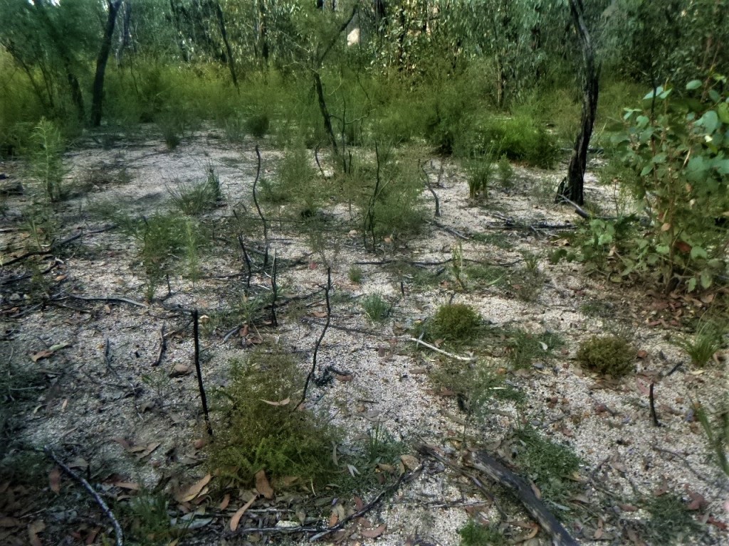
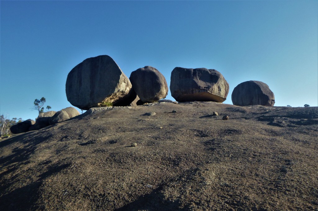
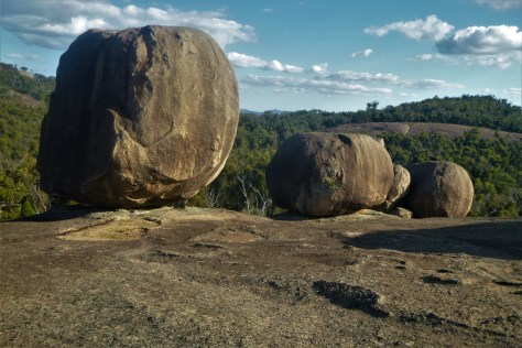
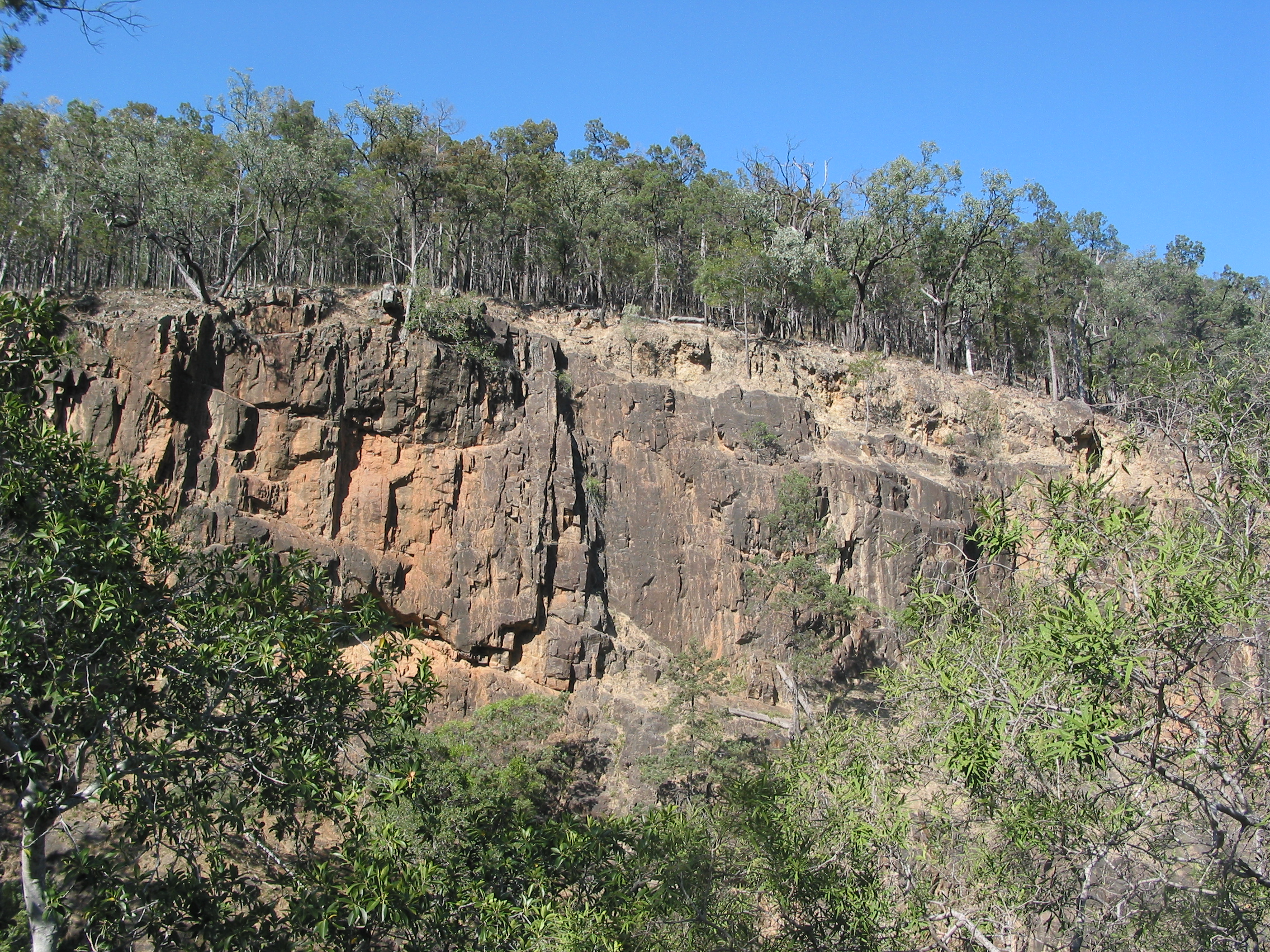
Wallangarra Ridge  is a little visited section of Girraween National Park in Queensland’s Granite Belt.  It is a spectacular landscape of   granite domes,  extensive rock slabs  and  giant balancing tors.  The dominant vegetation is a low Eucalypt woodland still showing the fire scars from 2019 bushfire season.  As the bulk of the walk is off-track , some navigation skills are needed.

Location of Girraween National Park. Source: Geoscience Aust.

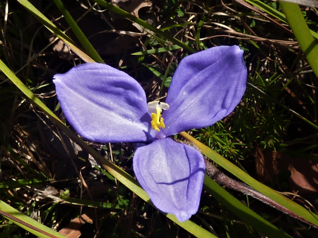
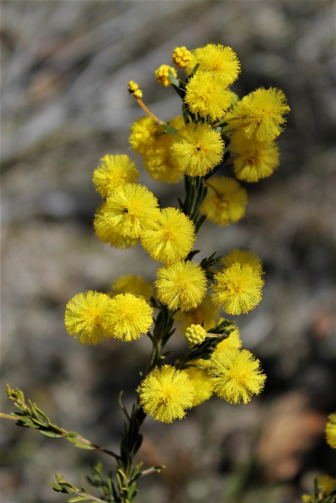
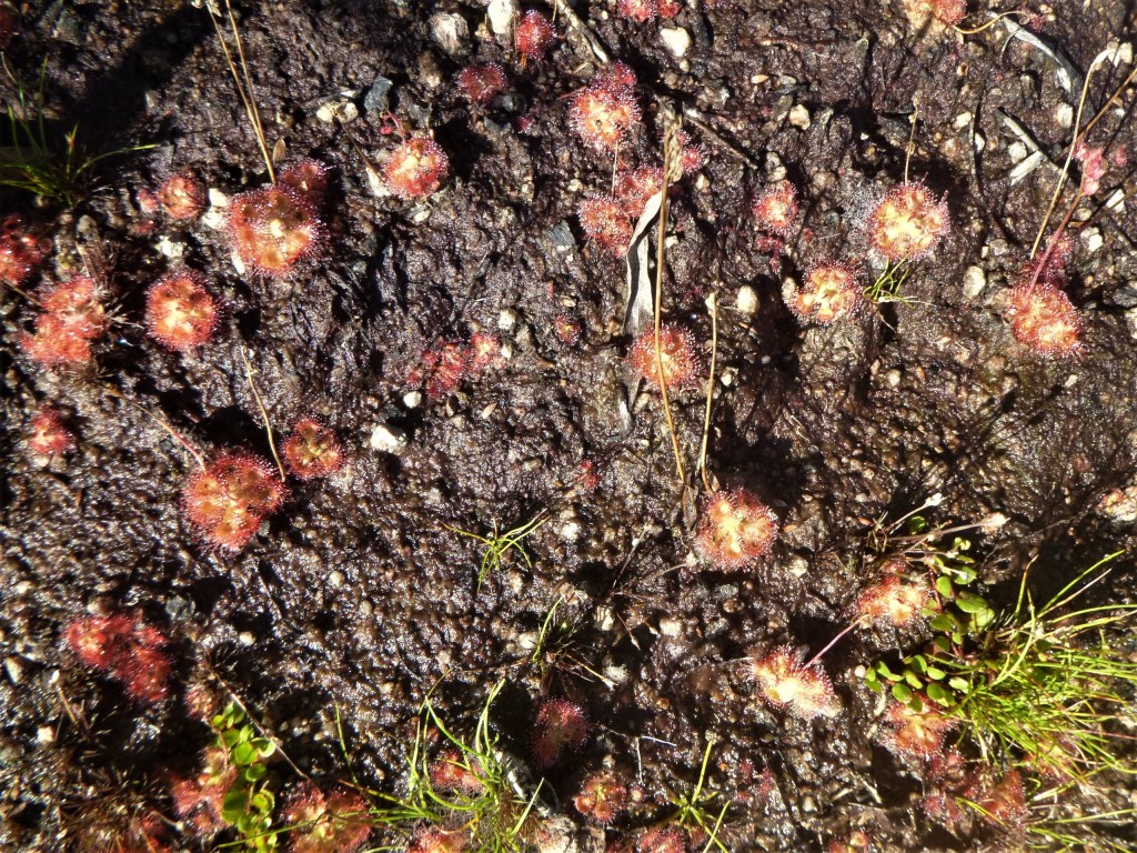
Girraween means ‘ Place of Wildflowers ‘

The Wallangarra Ridge  sits at 1100 metres, while predictably cold in winter it was still quite warm during the day. Late March, 29 degrees centigrade. The  scrubby vegetation made long-sleeved shirts and  trousers a wise satorial option. 

The Parks website  provides this irresistible description of the Wallangarra Ridge : “…  breathtaking views sweep over to the Wallangarra township and distant rolling hills.  Soak up the vistas of nearby Mallee Ridge,  the giant monolith known as The Turtle  and Girraween’s  highest peak, the majestic  Mt Norman…On a hot afternoon,  cool breezes waft through the lush gullies between Mallee Ridge and Wallangara  Ridge .  Listen out for the rustling of bell-fruited mallee…You’ll soon forget the gruelling climb!

View across to our campsite on Wallangarra Ridge. Girraween NP.
View across to our campsite on Wallangarra Ridge.

Geology

The geology of Girraween  is not particularly  complex.  The area is the remnant of a pluton of Stanthorpe Adamellite ( a quartz monzonite ), which is a major unit of the New England Batholith,  intruded  as a  molten  mass in the Early Triassic,  some 225 mya.

Stanthorpe Granite
Stanthorpe Granite

As the overlying rock was eroded the granite  mass expanded setting up stress fractures forming regular rectangular  joint patterns.   These rectangular  erosional jointlines had a strong influence  on the development of  Girraween’s  landforms.  Girraween’s domes, tors,  rock slabs and rectilinear drainage  pattern  are typical of granitic landform assemblages throughout the world.

Granite Landscape of Girraween NP
Panaoramic view of Granite Landscapes of Girraween National Park.

Sunday

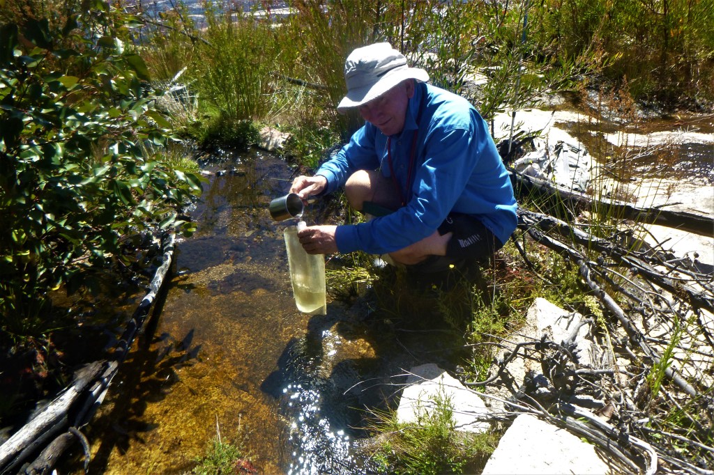
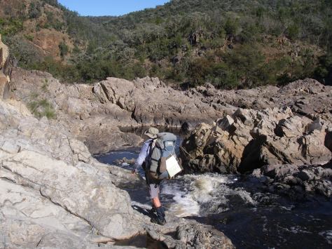
After a long five hour drive from the coast we pulled into the Park HQ on a pretty warmish afternoon. A hurried lunch and we were heading south on the Castle Rock-Mt Norman track, more uphill than I wanted. Neither my fellow hiker, John, nor I were keen to haul in water supplies for two days of walking and camping so the plan was collect some on the way to Wallangarra Ridge. Finding said water supply proved elusive as most gulleys and creek beds were dry,. Surprising given recent rains in a strong La Nina season . But a little bit of detective work and some scrub bashing unearthed a trickle hidden in a glade of ferns. Enough to provide an initial five litres each. Tomorrow we would have to replenish the supply. But our 1:25000 topo map showed nothing in the way of perennial streams in our intended camping zone. All we had to do now was to haul the additional five kilograms on the 250 m climb to the The Sphinx and then to the track terminus at The Turtle. From here it was all off-track.

The Turtle and The Sphinx. Girraween NP>
L. The Turtle at track head and R. The Sphinx.

Navigationally,  it was simply a matter of following our noses around the eastern cliff line of The Turtle and heading  SSW along the 1100 m contour line.  This involved a fair bit of bush-bashing and picking the easiest route between and around the large outcrops of granite.  To avoid too much bush-bashing, we took to open rock slabs whenever the opportunity arose.

Fire ground after summer bushfires. Girraween NP.
Regrowth after summer bushfires.
Granite Tors: Wallangarra Ridge
Easy walking on open granite slabs.

By late afternoon, our enthusiasm waning, we propped at a rare flattish patch of sand nestled between rock slabs and boulders and relatively clear of burnt out scrub.  It was too late to go galivanting around looking for the Wallangarra Ridge Remote Campzone still some one and a half kilometres to our South-West and 100 metres down in a decidedly scrubby looking valley. I’m not sure why camping down there would offer any positives.

Our camp  nestled on  a rare patch of level sand.

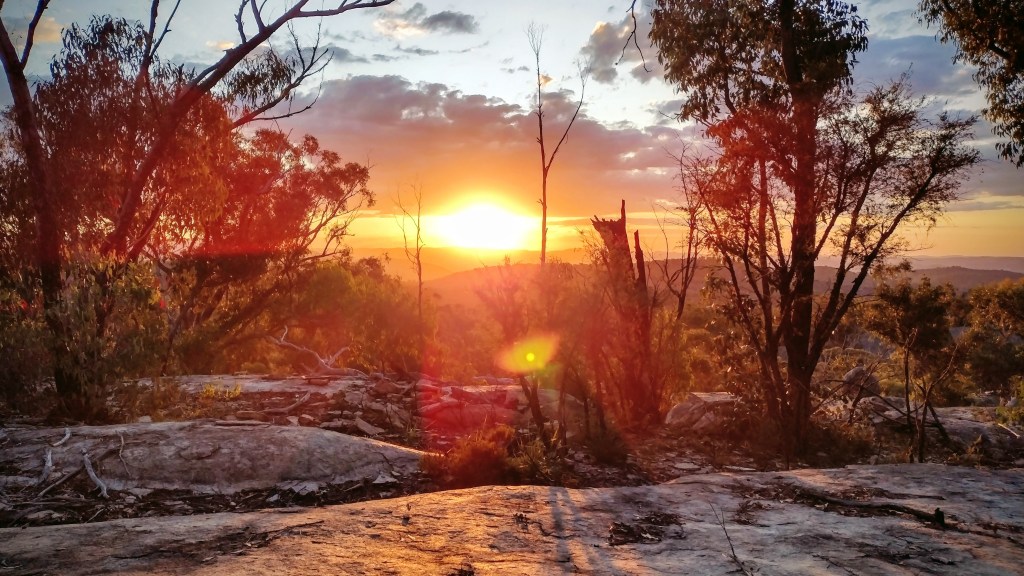
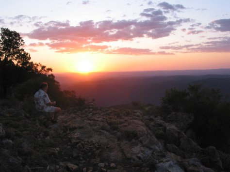
After several cups of black tea to rehydrate,  we ferretted out all our warm gear, donning  trousers, thermals, fleece coats and beanies and wandered  out to take in a spectacular a  red sunset .

Sunset from Wallangarra Ridge. Girraween NP.
Sunset from our camp on Wallangarra Ridge

Our rocky  eyrie looked  out  over the Queensland /New South Wales township  of Wallangarra, some six kilometres to the  south.  In the far distance  was the Roberts Range, marking  the  boundary of Girraween’s  sister park, Sundown.

The Roberts  Range

The Roberts Range is a 1000 metre divide that separates the Severn River to the north from its southern neighbour, Tenterfield Creek.  Both are tributaries of the Dumaresq River.  It is named after Francis Edwards Roberts, the Queensland Government Surveyor who was involved in the 1863 border survey together with his New South Wales counterpart , Isaiah Rowland.   There are plans afoot to expand the Protected  Area Estate in the Granite Belt to include the Roberts Range area and help link Girraween and Sundown National Parks. Another concept under consideration is a Border Walking Trail along the easement of the Qld – NSW border.

Border Track. Roberts Range.
NSW – Qld Border Track on Roberts Range. Sundown NP.

This easement is a well maintained 4WD track that parallels the border fence, technically a Dog Check Fence.  The walk along the fenceline easement is a classic high range roller-coaster, up and down…up and down. A winter walk without parallel.  Believe me when I tell you that it is best avoided  over summer.  Read more about the Roberts Range walk at the end of this post.

Back on the Wallangara Ridge we had no campfire.   A cold WSW wind sent us scuttling off to our tents, lulled to sleep by forgettable podcasts and the occasional hooting of Boobook owls.

Monday

5.30 am . Rolled out to another crispy Granite Belt morning.  John was already up, cranking up the stove for our coffee followed by a substantial bowl of thick creamy porridge.  In my case, a tried and tested mixture of rolled oats, raw muesli, sultanas, plump dried apricots, shredded coconut and lashings of powdered milk. Fuelled up, we were up and running ( walking ) by 8.00 am.

Today was off-track to reach the high point of Wallangarra Ridge SSW of our campsite, as the crow flies.  If only we were crows.  We had read somewhere that the summit  is marked by a small rock cairn, from which we were promised extensive views across the park and down to Wallangarra township.

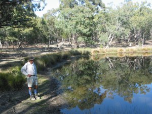
But first… find some water.  Our thought bubble of siphoning and filtering stagnant water from shallow pits and pans ( sometimes referred to as gnammas )  in the granite didn’t appeal.

Unappealing stagnant water in a shallow pan near our campsite.

But the gods smiled.   Several La Nina seasons meant that we should stumble across a trickle in nearby swales. Which we did.   In a swale no more than 500 metres downhill from our camp. Pretty unusual.

Surface water in swale. Wallangarra Ridge.
Surface running water in a swale downhill from our campsite.

The swales are clothed in ‘Gully’ open woodland which develops in sheltered run-off situations I identified a few of the scorched dominants: Banksia spinulosa, a Callistemon , Eucalyptus brunnea and a dense regenerating understorey.

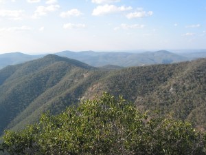
From the scrubby swale our line of travel took us out and up onto our morning tea vantage point where we propped in the shade at the top of a series of rock slabs stairs.  A short distance to the west  we could make out the highest part of Wallangarra Ridge .   John scanned along its skyline with his telephoto lens until he located a mini summit cairn.  Behind us and off to the north were easily the best views of The Sphinx and Turtle in the whole park.  

Twenty minutes later we stood on the summit boulder at about 1140 metres.  To our south was Bald Mountain ( 952 m ) and six kilometres in the distance was the border town of Wallangarra.

Summit cairn. Wallangarra Ridge. Girraween NP.
A windy morning on the summit of Wallangarra Ridge. Mini rock cairn. Roberts Range on horizon.

Wallangarra

Wallangarra is a small town of 500  0n the border of Qld and NSW.  It grew up close to the site a 1859 border survey marked tree, indicating the border between Qld and NSW. 

It is on Ngarabal country with Wallangarra  said to mean ‘ lagoon’.  I have read that wallan means water and guran means long. Long water as in billabong or lagoon.

Meanwhile, back on Wallangarra Ridge, we  drifted off northwards down the toe of the ridge in search of the mythical official  Wallangarra Ridge Remote Bush Camping Zone.  Unsucessfully.  After an hour of thrashing around in the dense regrowth in the vicinity of the GPS coordinates provided, we gave up. Anyway, there was no chance a slotting a tent in this stuff.  Bit of a navigational  mystery actually.  According to the Parks website … ” there is no defined camp site and access is via difficult cross country walking “.  We turned for home, intent on  finding enough water to see us through another day.

Water supply. Wallangarra Ridge. Girraween NP.
Lucky to find a supply of fresh water.

Back at the ranch we settled in for a decidedly leisurely and late lunch, several brews of hot black sweet tea and a nanna nap in the shade.  Though the latter was moveable feast as we searched for the deepest  shade.

Come late afternoon, John sloped off, camera on alert.  No doubt off to hunt down any unsuspecting Lyrebirds and Button Quail which he was convinced were scratching through the heaps of leaf litter.  Meanwhile I wandered around checking out all the nearby rock slabs hoping for anything of  geologic or botanic interest .

The Superb Lyrebird

( Menura novaehollandiae )

Lyrebird. Artwork by Sydenham Edwards ,1802. NLA.
Lyrebird. Artwork by Sydenham Edwards ( 1802 ). NLA.

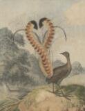
On a previous trip to Girraween we had been fortunate to see and hear Lyrebirds at nearby Mt Norman, so weren’t surprised to hear them again close to our campsite.

The Lyrebird is one of nature’s best mimics.  It can imitate a variety other bird species such as cockatoos, butcherbirds and whipbirds.  But it doesn’t draw the line at bird calls.  It can reproduce the sound of saws, guns and engines.

One Lyrebird story I read happened at a Victorian timber mill.  The mill used three blasts of a whistle to signify an accident and six blasts to notify a fatality.  One day the local Lyrebird blasted out six whistles, no doubt creating considerable workplace disruption. 

I have been tricked by  a Lyrebird mimicing the sound of a ‘reversing’ truck.   Our hikers’ camp in Sundown National Patk was hidden in  scrub with a small 4WD campround nearby.   The sound of a ‘reversing’ vehicle  at the 4WD campground attracted our attention as it had persisted for well over fifteen minutes.   I waddled up to check things out, thinking perhaps a 4WD had bogged or some such problem.  No vehicle in sight but the ‘reversing’ sound continued from the undergrowth.   The mystery of the phantom 4WD camper was solved.  Lyrebird.

Interestingly, scientists know that some mimicry is of now extinct species, passed on from parent to chick over the generations.

Another sunset worthy of the ABC TV weather report , a decent feed, a chin wag and it was all over for today. My Macpac micro green tent beckoned.

Tuesday

5.30 am.  Time to roll out into the pre-dawn twilight.  My pocket thermometer hovering on 10o C with a cool Southwester riffling across our campsite.  A bite to eat then we struck camp, packing our gear and leaving tents out to dry.

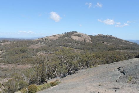
Our walk today was off to our east onto an unnamed adjacent ridge, aligned in the same NE/SW configuration as the Wallangarra Ridge. At 1220 metres it is nearly 100 metres higher than Wallangarra Ridge and more densely vegetated.   The attraction  was that from its summit we should be able to see across to the complex that makes up Mt Norman ( 1266 m ) and the Mallee Ridge ( 1230m ).  Maybe our Girraween sojourn for next year.

Summit of Wallaroo Ridge. Girraween NP
Summit of Wallaroo Ridge

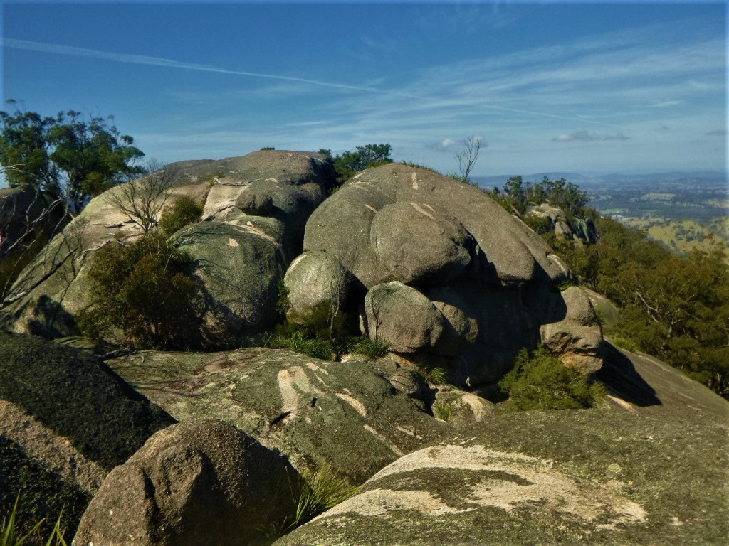
Our line of travel took us initially over lower rock slabs then climbed into mature stringybark forest, habitat for a  Wallaroo, a large furry macropod,  which took off when we disturbed it.  We wound in and out of huge granite boulders before fetching up on a narrow summit plateau at 1200 metres.  Perched on the plateau were jumbles of huge tors topping out at over 1220 metres.  Naming rights… Wallaroo Ridge.

Wallaroo aka Euro

Our Wallaroo ( Osphranter robustus ) was, as the specific name implies ,  sturdy ( and shaggy-coated ) .  They are generally solitary and nocturnal.  The Eastern Wallaroo is not on the threatened species list and has an extensive territorial range in Australia’s Great Dividing Range.

Wallaroo. Osphranter robustus
Eastern Wallaroo. Osphranter robustus

We scrambled to  the top of the highest tor for morning tea.  Now we had impressive clear easterly views to the domes of Mallee Ridge and Mt Norman.   Mt Norman was named after Sir Henry Norman, Governor of Queensland from 1889 to 1895.   Getting to the Mallee Ridge and thence to Mt Norman from here looked like a hard slog.  Maybe one for the future.   Fortunately, there is an easier way,  from the Mt Norman track.   Although the twin domes ( 1230 m ) at the SW end of the ridge looked a tad formidable.  My Hema Girraween  map describes the walk as… ” easy rock slopes “.  I live in hope .

Mallee Ridge in sunlight taken from Mt Norman

Bell-fruited Mallee & the Mallee Ridge

While  traversing the lower rock slabs, we had spotted a line of Bell-fruited Mallees growing in a jointline which had retained a bare minimum of mulch that was enough to sustain a viable pocket of Mallees.  These were the mallee Eucalyptus codoncarpa ,  that also grows on the nearby Mallee Ridge, and after which it was named.  In Girraween, the Bell-fruited Mallee is only found on Mt Norman and rocky outcrops to its west and south- west.  Despite its somewhat restricted distribution in Girraween it is listed on the IUCN Red List of Threatened Species as being of ‘least concern.’

Bell-fruited Malee. Eucalyptus codoncarpa.
Bell-fruited Mallee. Eucalyptus codoncarpa

Morning tea rest over, we backtracked to our campsite where we polished off our lunch leftovers and the inevitable mug of tea.  With a final check of the campsite, we hoisted up the monkeys and waddled  off for a leisurely afternoon’s walk back to our overnight camp at Bald Rock Creek campground.

One of the attractions of poking around offtrack is that little surprises form part of the experience.   This time we chanced on a high  ledge festooned  with a mass of rock orchids  and then futher on, an unusual find, a Bootlace Orchid.

Rock Orchid. Dendrobium sp
Rock Orchid. Dendrobium sp.

The Black Bootlace Orchid

The Black Bootlace Orchid ( Erythrorchis cassythoides ) is a leafless climbing orchid. It has thin, dark brown to black stems that climb up to five metres up tree trunks.   It has displays of 10 to 30 yellow to green flowers.  Surprisingly, a Bootlace popped up in my suburban native garden in SEQ, lasted several years, then died back for no reason that I could figure out.

Flowers of Bootlace Orchid. Girraween NP
Flowers of Bootlace Orchid

The Bootlace was first described by Richard Cunningham who sent his specimen and descriptive notes to his brother, the explorer Alan Cunningham.  Alan Cunningham forwarded the description on to the the English orchidologist, John Lindley.  Richard Cunningham had originally named it Dendrobium cassythoides but it was later renamed as E. cassythoides.

By 4.00 pm we were setting up for our final night in the civilised surrounds of Bald Rock Creek Campground. Although this had been a short visit to Girraween, we had explored a littled visited section of this outstanding granite park which I had always been keen to investigate. Coming up next year … the Mallee Ridge.

A description of one of my walks on the Roberts Range

The walk is the classic high range roller-coaster starting at 1067 metres, dipping and rising: 973 m, 1039 m, 1030m, 1015m, 1087m and reaching 1120m at our final climb before turning off and descending to the Sundown Road.

Roberts Range. Sundown NP
4WD track on crest of Roberts Range on a hot day. Sundown NP

Climbing up to our first high point, Hill 1067 we passed into a special habitat, a high altitude forest, restricted to the very highest parts of Sundown and the Granite Belt. This is open forest, dominated by Silvertop Stringybark (Eucalyptus laevopinia), Yellow Box (E. melliodora) and the best name of all, Tenterfield Woollybutt (E. banksii). Silvertop Stringybark and Tenterfield Woollybutt are interesting in that they are disjunct populations of the same species growing further east at Lamington and Mt Barney. It is likely that they survive here on traprock because of the cooler, misty micro-climate on the highest points of the Roberts Range. Further along the range, on the summits of the highest hills at 1087 metres and 1120 metres, we passed through more small patches of high altitude forest.

As we climbed to the final high point at 1120 metres we entered a designated ‘essential’ habitat. These are areas meant for the protection of a species that is endangered or vulnerable. In this particular case the species was the Superb Lyrebird (Menura novaehollandiae) neither seen nor heard by our party. The Superb is the King of Karaoke and is such a good mimic that the bird being copied cannot tell the difference. The male Lyrebird has a repertoire of 20-25 other bird songs as well as mimicking car engines, chain saws and even barking dogs.

When Queensland was proclaimed a separate colony on 6th June 1859, Surveyors Roberts from Queensland and Rowland from New South Wales were sent to define the boundary between Queensland and New South Wales from Point Danger to the Dumaresq River. They started work in 1865 and worked separately using their own instruments. As their traverse lines were different the defined border appeared in different positions. Ultimately the Roberts survey was accepted and this was the line depicted on our map and that we were following today. I was keen to find any relics of their traverses such as rock cairns or horse-shoe blazes on trees. I found one old blaze, indecipherable, so there is no evidence that it was part of the border survey. It would be interesting to do the entire Roberts Range traverse with data from Robert’s original field book.

Old Survey Blaze on Qld – NSW Border.

Roberts, an Irishman, trained as an engineer and in 1856 he became surveyor of roads for the Moreton Bay District later gaining a post as a surveyor with Queensland’s Surveyor-General’s Department in 1862. Colonial surveyors were tough, capable bushmen able to endure considerable hardship: life under canvas, poor food, heat, flies, arduous travel and isolation. Unsurprisingly, it was a constant struggle to stay healthy. Queensland colonial surveyors could be struck down by any number of health hazards: Barcoo Rot, Bung Blight, Sandy Blight, Dengue Fever, Malaria, snakes and crocs. Francis Roberts escaped all these only to die prematurely of sunstroke in 1867, aged 41.

Today, the border is marked by a Dog Check Fence; an outlier of the mighty 5,412 kilometre Dog Fence that runs from Jimbour in Queensland to the Great Australian Bight in South Australia. The Dog Fence is said to be two and a half times the length of the Great Wall of China and is easily visible from space. Our 1.8 metre high Dog Check Fence or Dingo Fence is a relic of an intricate maze of some 48,000 kilometres of interconnecting vermin fences built to keep dingoes and bunnies at bay. Unsuccessfully.

Sunset at Sundown. Southern Sundown National Park. Qld.

By Glenn Burns

The following account is of a three day bushwalking circuit that I did with two friends in southern Sundown National Park in which we followed up McAllisters Ck, a deeply incised tributary of the Severn River. From McAllisters we ascended  onto the Roberts Range at about 900 metres. After a long hot walk along the high Roberts Range we turned  westwards pushing through dense undergrowth to overnight on Mt Donaldson at 1038 metres. The following day we descended back into the Severn River.

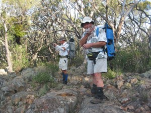
In early October, walking friends Frank Truscott, Don Bell and I completed a three day bushwalking circuit in Sundown National Park taking in some very interesting and challenging landscapes on the way. Although only thirty kilometres from Girraween as the crow flies, Sundown has little in common with the benign rounded tor  landscapes of the Stanthorpe Granites.

Rugged Sundown Landscape

Sundown offers a terrain of deeply incised creeks, gorges, waterfalls and steep stony ridges rising to 1000 metres. It is an inhospitable environment, dry and rocky. To me, a landscape reminiscent of the MacDonnell Ranges of Central Australia. Early settlers described it as “traprock”, geologically incorrect but an apt descriptor all the same. Traprock is a term applied to basalt landscapes in the UK while Sundown’s surface geology is predominately sedimentary which has been  altered by heat and pressure (termed: metasedimentary).

Photo Gallery

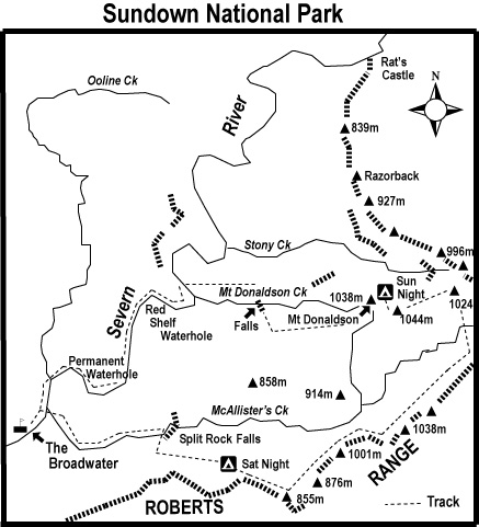
Our trip followed an anticlockwise circuit: from the Broadwater up the gorge-like McAllister’s Creek, to Split Rock Falls; a climb to the Roberts Range at 800 to 1000 metres; a major scrub bash to Mt Donaldson (1038 metres); a steep descent to Mount Donaldson Creek and the spectacular Donaldson Creek Falls and a return down the boulder choked Severn River to the Broadwater Campground.

Sundown National Park

Link to another of my Sundown Walks:

Sundown is a remote and rugged National Park a mere thirty kilometre stone’s throw to the south-west of Queensland’s very popular Girraween National Park. My bushwalking friend Brian and I have, over the years, traipsed many a kilometre along the Severn River in Sundown. This is an account of one of our many expeditions in Sundown.

Geology of Sundown National Park

Sundown’s stony terrain had its origins in the Carboniferous Period (360million – 286 million years ago). Sediments from a volcanic mountain chain on the eastern edge of the Gondwana continent were deposited on the continental shelf and later avalanched onto the deep ocean floor. The sediments formed thick beds of sands, silts and mud. Compression and deformation of the beds resulted in the metasediments of the Texas Beds. The predominate rock types of the Texas Beds are Argillite and Greywacke. Argillite is a dark grey/black mudstone, very fine grained and extremely hard. Greywacke is a coarse grained sedimentary of mixed composition, also very hard. These were later uplifted to a mountain chain, the remnants of which form the tilted hilly ridges of Sundown.

DAY ONE
McAllister Creek Gorge

We left Broadwater mid afternoon and rock hopped up McAllister Creek to Split Rock Falls. Here the creek was deeply entrenched in a narrow red gorge, defying Frank’s GPS to find the requisite number of satellites. Following Don’s confident lead we hung from cracks and crevices, teetered along dubious ledges, finally reaching the barely trickling “split” falls, impassable…. of course. Our bypass was a steep scrabbly climb on the spine of a rocky ridge to our campsite in a cypress pine grove at 800metres. One of the very few open areas in an otherwise very stony terrain. At 6.30pm, on sunset, we downed packs and settled into our campsite, complete with its own comfortable log seats and frug of whining mosquitoes. I soon lost my desire to join the “sleep under the stars” contingent as a full moon rose and the mosquitoes settled in for the duration. Instead I retired in comfort to my insect/moonlight proof “Taj Mahal”.

McAllister Ck Gorge
McAllister Ck Gorge

DAY TWO
Roberts Range

Our traverse along the crest of Roberts Range on the second day followed one of the ancient ridges. The Roberts Range was a roller coaster of elevation gains followed by steep descents. Hot work. Incredibly, we found two small dams high up in the catchment where we could replenish our water supplies and wash. Mid afternoon we swung off the Roberts Range heading for Donaldson.

4WD track on crest of Roberts Range

Mt Donaldson

Progress faltered to about one kilometre an hour and visibility fell to ten metres as we pushed through unpleasantly dense thickets of Peach Bush (Ehretia membranifolia) and Cough Bush (Cassinia laevis). On occasion, one of our trio would disappear into a thicket failing to re-emerge after an appropriate wait. Several cooees usually provided the necessary geographic re-orientation and a bleeding bruised body would come flailing through the undergrowth, in due course.

Rough going near Mt Donaldson

On the summit of Mt Donaldson on our second evening we found some younger Permian breccias on top of the Texas beds. Breccias are sedimentaries composed of coarse, angular fragments of older rocks. My guide book implied fossil shellfish aplenty these outcrops. Even Blind Freddy should find one. The breccias were obvious enough but the fossils weren’t. Unfortunately, my conscience wouldn’t allow me to shatter rocks to find them, tempting though the prospect was.

As the sun set we perched on rocky benches above the cliffline and took in the view. This is reputed to be the best vantage point in the park, not an exaggerated claim. A rugged landscape unfolded: Donaldson’s northern summit was fringed by massive cliffs; stretching off to the north east was the Razorback (Berchtesgaden on my map) a ridgeline of numerous 900 and 800 metre hills grading down to the Rats Castle (a granitic dyke) on the Severn River, four kilometres away. Immediately below was the Stony Creek valley, lined with numerous scree slopes of shattered boulders. My track notes advised that walkers should not be

tempted to descend Stony Creek since it is strewn with large boulders.”

On a distant western cliffline a trip of goats skittered along a narrow ledge, intent on finding a night bivouac in the thick brush.

DAY THREE

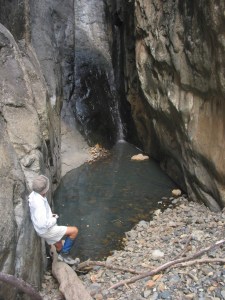
With the Stony Creek warning in mind, we left Mount Donaldson at 5.30am, chased off the summit by gale force winds and a suspiciously thick cloud bank building to our east over Stanthorpe. We descended steeply into Mount Donaldson Creek. Here we rewatered, dropped packs and headed downstream to inspect Donaldson Creek Falls, developed on resistant strata, with its 100m drop towards the Severn River. 
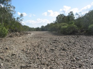
The views down a red canyon to the Severn did not disappoint. Saddling up again we bypassed the falls and descended 230 vertical metres to the Severn River Flood Plain. The bed of the Severn is confined to the NNE trending Severn River Fracture Zone. It is interesting that the river has not diverted around the harder Texas Beds but has continued to cut down into the resistant metasediments. Consequently, for such an old land surface the sinuosity of meander looping of the Severn is remarkably undeveloped. The sinuosity ratio for the Severn in Sundown is 1.04; very close to the ratio for straight, younger streams such as the Johnstone River (North Queensland) which has a ratio of 1.00. A stream channel on a flat flood plain will often have a ratio of 3.00 or more (technically described as tortuous). Still, this was all useless palaver as we hoofed the final six long hot steamy kilometres along a rough bouldery river bed to our final destination at Broadwater.

My thanks to Frank and Don for their invitation to join them on the Sundown  trip and for some great navigation and geology

References:

Willmott, W, 2004:   Rocks and Landscapes of the National Parks of Southern Queensland.

Mapsheets:

  Sundown National Park   1:50,000 ( Hema Maps)

Mount Donaldson   1:25,000

Mingoola   1:25,000


Sundown National Park

By Glenn Burns

Sundown is a remote and rugged National Park a mere thirty kilometre stone’s throw to the south-west of Queensland’s very popular Girraween National Park. My bushwalking friend Brian and I have, over the years, traipsed many a kilometre along the Severn River in Sundown. This is an account of one of our many expeditions in Sundown. 

Brian, ever the expedition genie, had again conjured up yet another ‘exploratory’ trip covering central and northern Sundown. This time we would venture  high up onto the Roberts Range which marks the southern boundary of Sundown and forms the state border between Queensland and New South Wales. The only fly in the ointment was our intended access to the Roberts Range, over Mt Donaldson. Those who have tramped this way before will recall the swathes of dense undergrowth with a certain sense of trepidation.

The Severn River: Sundown National Park

Sundown is said have been given its name by old bushmen who thought that its valleys were so deep that it was always ‘sundown’. It is a spectacular landscape. Named after the Severn River in England, this deeply incised antipodean Severn, with its waterholes, cool side gorges and waterfalls makes for relatively benign walking. But away from the river, Sundown can be inhospitable. Dry, stony ridges rise to well over 1000 metres, the so-called ‘traprock’ country. The highest hills are invariably smothered in tangled thickets of Peach Bush, Cough Bush, Hop Bush and other shrubby pleasures like the prickly Dead Finish: all right up there in nuisance value with wait-a-while and lantana.

View from Mt Donaldson overlooking The Razorback

The lure for me in all this was that we would be following the old Roberts Range border survey line set out in 1863 by Francis Edward Roberts, Queensland Government Surveyor and Isaiah Rowland, Robert’s counterpart from New South Wales. Although Brian and I had walked a small section to the south-west several years ago, we could now complete another leg over the highest part connecting Mt Donaldson and the old Sundown homestead site. My fellow expeditioners, experienced throughwalkers all, were quick to sign up to four days of the rumoured slacking down the Severn, early finishes, superb high range campsites and heaps of firewood for our evening fires. Buyer Beware.

Photo Gallery: Sundown National Park

Wednesday 25 April: Sundown Homestead site to Red Rock Creek: 5.5 kms.

Eight bushwalkers mustered at the old Sundown Homestead site on a decidedly coolish Granite Belt afternoon: Brian (leader), Alf, Christine, Jenny, Roland, Sally, Samantha and one well rugged-up scribe. Temperatures had dropped to a nippy 14°C as a blustery 40 kph sou’westerly swept in. Hardly unexpected, as this is Queensland’s coldest district, with eight months recording temperatures below 0°C. Sundown’s Park HQ at The Broadwater has recorded a creditable minus 8°C. Fortunately the average minimum for April is a more comfortable 9.5°C.

Walkers @ Rats Castle

But cool was cool for our five and a half kilometre uphill walk in along the old 4WD track to our Red Rock Falls campsite. For those humping in their supplies of birthday cakes, apples, sourdough rye bread, cheeses, a hogshead of red wine and a hundredweight of juicy Kalbar carrots, the track kindly winds its way ever so gently upward, a modest height gain of only 160 metres from the homestead. At the base of Hill 983 (metres) we shrugged off our well-stocked packs for the short walk into Red Rock Falls Lookout.

Source: Glenn Burns

Red Rock Falls & Sundown’s Geology

From the lookout, the full story of Sundown’s geology and topography could be read in the landscape revealed before us. This rugged terrain had its origins in the Devonian-Carboniferous Period some 370 to 290 million years ago. Sediments from a volcanic mountain chain on the eastern edge of the Gondwananan continent were deposited on the continental shelf and later avalanched into deep ocean trenches. Thick beds of sands, silts and mud were compressed, hardened and deformed, producing the very hard metasedimentaries of the Texas beds. In a later episode of mountain building, the metasediments were uplifted, tilted and fractured to form a mountain chain, the remnants of which are the ridges and hills of Sundown. Later, during the Triassic (248 -213 million years ago) a small body of Ruby Creek Granite was intruded into the Texas Beds and now outcrops at Red Rock Gorge and Jibbinbar Mountain to the north, but also triggered major fracturing of the Texas Beds. It was also responsible for the mineralization of the Texas Beds and the formation of Rats Castle, a granitic dyke. For a detailed explanation of the geology of Sundown NP go to Warwick Willmott’s excellent tome: Rocks and Landscape of National Parks of Southern Queensland.

But our immediate attention was drawn towards the now dry Red Rock Falls. As Alf pointedly remarked to our leader:

“The falls aren’t falling, Brian. Can we get a refund?”

By way of compensation, there were panoramic views along the red cliff lines which plunge a good 50 metres to the Red Rock Creek gorge below. In reality the granite cliffs are sandy in colour when freshly broken, but have been stained red by lichens on undisturbed surfaces.

Red Rock Falls: Sundown National Park.

The touristy bit done, we mooched back to retrieve our packs and strode off to our first overnight campsite. A Sundown Hilton. Grassy, level tent sites, plenty of water and ample firewood. After my 5 am start and the tedious drive to Sundown, a Bex and a good lie down beckoned. I had barely thumped in my last tent peg when Brian, whose largesse never extends to free time, rounded up the lethargic and indolent for some late afternoon exercise down Red Rock Creek to peer over the falls.

Campsite on Red Rock Creek

Thankfully the biting sou’westerly gusting up the cliff face quickly dampened any corporate enthusiasm for poking around and the natives were unusually  restless. Brian did manage to steady his now pretty toey charges long enough to point out a brownish smudge on the horizon, which he insisted was the grassy knoll where we would have morning tea on the morrow.

Afternoon stroll down Red Rock Creek

Back at the campsite firewood was scrounged, the fire lit, and cups of soup, tea and coffee brewed. And as the light faded from a sailor’s delight sky, the bush chefs gathered to whip up an epicurean extravaganza. Brian resorted to an old favourite of his, bangers and mash with a side dish of green peas. But for my money, bangers and mash or all those Backcountry Pantry roast lambs and veg didn’t compare with Jenny’s culinary coup, a Scotch Devil. A hard-boiled egg covered with crumbed sausage meat and deep fried. A meal fit for any claymore-wielding Highlander and a kilojoule king-hit capable of propelling Jenny to Jupiter and back.

The Song of Roland

Meal over, we warmed our bottoms over the crackling fire while Roland regaled us with one of his many tall tales, occasionally true. Not Roland and the Midnight Koels’ this time, butClose Encounters of the Dingo Kind’ set in The Valley of Giants, Fraser Island. I recall another of Roland’s dingo dingles in Central Australia when Brian, Bernard, Di Hoopert and I were due to link up with Roland at Furnace Gully near Redbank Gorge on the Larapinta Trail. After two days of cross country travel from Mt Zeil and manyCooees” andRoowlaands” we finally looked down on a disconsolate Roland perched in a baking, bleak and windswept gully, the ultimate Mars landing experience. A black and tan dingo was slowly prowling the perimeter of the campsite, patiently stalking its prey in ever decreasing circles. Back in Sundown it was off to bed for these little puppies, lulled to sleep by friendly frog calls and the distant rush of wind through the trees on the high ridges above.

Thursday 26 April: Red Rock Ck to Burrows Waterhole: 8.5 kms.

5.15 am. Birthday boy Brian was already on the move. The usual clanking of billies and mugs, stirring up the campfire and dispensing cups of tea and coffee to all and sundry. Other bleary-eyed bushwalkers gradually trickled out into a crisp Granite Belt morning, 1°C, grateful for a warming fire. While the others hovered over the fire I waddled off to check out a small mullock heap and mine pit that Brian had found nearby. Sundown was the site of a number of mines producing molybdenite, tungsten, copper, arsenic and tin. In fact, the first tin deposit found in Australia was on the nearby Nundubbermere Run in 1854.

Mining at Sundown

The Sundown Tin Mine opened in 1893 and operated until 1923 when it closed only to re-open in 1953, finally closing in 1956. It was by far the biggest producer in the area but other mines were Carpenters Gully, The Orient, and Beehive. Copper sulphides were worked at The Sundown Copper Mine (1888 to 1908) and nearby Comet Mine. Arsenic was extracted in the early 1900s at Beecroft (1917 to 1927), Sundown Copper (1922 to 1924) and The Orient (1918) mines.

Beecroft Mine
Beecroft Mine

Arsenic was an important constituent in prickly pear poison, cattle dips and a hardener for the lead in bullets. Unfortunately arsenic oxide treatment has contaminated Little Sundown Creek and I have read that walkers are advised not to drink the water in Little Sundown below the mines.

Fortunately small mineral lodes, lack of water and poor access ensured any further exploitation in Sundown Resources Reserve was temporarily off the agenda. But this could all change under any future governments. The Sundown Resources Reserve does not have the same level of protection as its surrounding national park. In fact, during the 1980’s a mineral exploration company had been sniffing around the Severn River Fracture Zone west of the old Sundown mines and discovered bulk low-grade tin. But as Queensland’s former Premier Joh Bjelke-Petersen was apt to say to those pesky greenies, bushwalkers and press hacks:

Now, don’t you worry about that.”

0r the even more confusing:

We’ll come to that bridge when we’ve crossed it.”

By 7.45 am the party rolled out, climbing steadily the 100 metre altitude gain to Hill 1032. Strange, this climbing bit, given that Brian had described today’s route as a ‘downhill day’. Alf, ever the agent provocateur, inquired:

Is this another one of your uphill flat bits, Brian?”

But after Hill 1032 we indeed dropped down a long steepish 4WD track that took us through the Sundown Resources Reserve and finally up onto Hill 731, our morning tea spot, as promised. Sally produced a delicious pineapple cake while I unearthed the ginger cake that Judy had baked for Brian’s birthday bushwalking bash. A round of ‘Happy Birthday, Brian’ echoed through the hills while Brian huffed and puffed and finally blew out his three little candles. We wolfed down great slabs of birthday cake, sat back and took in the views back up to Red Rock Falls, three kilometres hence.

The Birthday Boy
The Birthday Boy

Our final descent of the morning was the 250 metre drop to Pump Waterhole on the Severn. This proved to be slowish work, gingerly picking our way down a steep hillside mantled with loose traprock. On the way down Alf called us over to inspect a pile of bleached bones:

Come and have a look at these bones. Hey, Brian. Are these bushwalkers from your last trip?”

Pump Waterhole probably takes its name from the fact that the Severn River was the source of water pumped up to mines or to stock tanks.

Pump Waterhole
Pump Waterhole

An hour later we ambled into Reedy Waterhole, lunch stop. I always take a wolfish interest in other bushwalkers’ food. Roland’s lunch today, for example, was distinctly continental: crusty sourdough rye bread, substantial slabs of cheese and several of those scrumptious carrots that he had carted in.

Burrows Waterhole Campground

After another half hour of rock hopping and two river crossings we strayed into Burrows Waterhole for an early mark. Brian’s fear that this official campground would be infested with squadrons of 4WDers was unfounded. A 2.30 pm finish. Unprecedented in the annals of Manuelian throughwalking. Burrows, a very large waterhole, was named after Fredrick James Burrows, a WW1 veteran who suicided in 1934 and his grave is said to be on the northern side of the river.

Burrows Waterhole
Burrows Waterhole

A grassy campsite, swims all round and an afternoon of unstructured mooching stretched ahead. Ever the wily coyote, I kept stumm about Fredrick Burrow’s nearby gravesite for fear of whetting Brian’s appetite for local history and back to back afternoon rambles. Anyway, the horses had already bolted. Jenny and Christine drifted off to check out the only other inmates of the campground; Samantha was engrossed in platypus watching; Sally sudokued; Roland brewed coffee, while Brian, predictably, kept himself busy rustling up the firewood and on matters navigational.Sunset came with another red sky, Venus and Mars peeking above the western horizon. The dark and cold folded in around us. So like the dingoes of Central Australia, our little pack crept ever closer to the warmth of a blazing campfire. Brian’s birthday bacchanal cranked up again, fuelled by more portions of birthday cake and washed down with a pannican of Alf’s finest vintage red wine. Or so he claimed. But by seven o’clock party pooping types headed for their snuggly sleeping bags. So off we all tottered. Jenny for her nightly Middlemarch fix, Brian to Agatha Christie, a turgid French novelist for Christine, travel stories for me, Alf to play cards, Sally to Sudoku, and Samantha to catalogue, classify, and coordinate her hiking kit in preparation for an early start tomorrow.

Roland relaxing at Burrows Waterhole

Friday 27 April: Burrows Waterhole to Stony Ck Junction via Rats Castle: 9 kms.

Woken at an ungodly 5 am and not by the instantly recognisable “zzzzip” of Brian’s tent. No, the guilty party was Samantha noisily rummaging around in her tent; re-reorganizing her gear so it was all ship-shape in Bristol fashion. I crawled out. Pitch black. An hour and half later, as first light tinged the eastern sky we luxuriated in the balmy 7°C conditions; the cloud and humidity a harbinger of the predicted rain due on Saturday. Today we were off to Stony Creek junction via Rats Castle. Stony was our jumping off point for the climb to Mt Donaldson and the Roberts Range. Rats Castle is a well known Severn River landmark that had evaded three dumb-cluck navigators on our 2011 Sundown walk. But not this time. We approached our elusive quarry from a ridgeline leading up from Little Sundown Creek and half an hour later we scrambled up onto its jumbled red granite boulders. Legend has it that the boulders of Rats Castle have been dynamited by vandals.

Rats Castle

Rats is an interesting geological feature, a ridge of hard fine-grained Ruby Creek granite which has intruded into the surrounding metasediments of the Texas Beds, weakened during major crustal distortions in the Severn River Fracture Zone. Technically it is a dyke, a vertical intrusion.

View over Severn River from Rats Castle

Early shepherds called it Rats Castle because when first seen, it was home to small rock wallabies, then commonly called rats. The rats were probably the Brush-tailed rock wallaby, Petrogale penicillata, listed as vulnerable and now found only at Nundubbermere Falls despite extensive surveying in Sundown. This shaggy-coated brownish wallaby has great agility on rock faces and can even scale sloping trees using its powerful legs and strong claws. It is nocturnal but cool weather will see it out basking on ledges in the sunshine. Unfortunately, it has been an easy prey for foxes, a target for shooters and the local population suffers from deleterious in-breeding.

For those bold enough to clamber onto the few summit boulders, Rats commanded great views over the Severn, 80 metres below. Ten minutes later eight pack rats were also below, having slithered and skated down over loose scree to the river bed. A smoko break. Here we bade a fond farewell to Roland who was returning to Burrows and like the proverbial penny would reappear two days hence, at Sundown Homestead. For the rest of us it was ever onward, past a herd of goats, past a fat pig and past a succession of waterholes: The Hell Hole, Turtle, Blue, Channel and Wallaby Rocks. Six kilometres, nine river crossings, one dodgy log crossing and we lobbed into our Stony Creek campsite soon after two o’clock.

Innumerable river crossing

Stony Creek Campsite

Another excellent campsite: remote, set on a flat alluvial terrace, grassy tent sites shaded by Sheoaks, Forest Red Gums, Cypress Pines and Rough-Barked Apples, ample firewood and a waterhole nearby. Tents went up quickly as the sky had clouded over and the wind had now swung to the east, rain threatening. With full cloud cover our maximum temperature barely reached a miserable 15°C. In fact, it was the coldest day of the month. But around the warmth of the campfire later in the evening Alf stepped up as raconteur-in-residence and entertained with travel stories from wildest Africa. Well, about as wild as you could expect from an Alf on a swanky safari to various South African diamond mines, gold mines and De Beers HQ. Just as we were being winched deep into the bowels of yet another diamond mine, a light shower of rain cut short our virtual tour and chased us off to our tents. But who would complain? Tucked into a toasty sleeping bag, light rain pattering down and a soporific page or two of James Elliot’s:  A Visit to Kanasankatan.

Packing up on a wet morning

Saturday 28 April: Stony Ck to Roberts Range via Mt Donaldson: 6 kms.

Climbing up to Mt Donaldson

Despite light rain all night we were all packed, kitted out in wet weather gear and gaiters, and ready to make tracks by 7 o’clock. Today would be our most challenging. Off track, pushing through manky vegetation, with a stiff 200 metre climb to Mt Donaldson Falls, then a second 420 metre climb to Mt Donaldson (1036 m) and onwards to Hill 1024 and Hill 1047 before dropping to our campsite on a spur of the Roberts Range at 960 metres.

Mt Donaldson

Initially navigation would be a cinch, merely following an old rabbit or dingo fence for the one kilometre climb to our old 2008 campsite at Mt Donaldson Falls. Light misty showers dogged us all the way along the fence line and the slimy wet traprock slabs in Mt Donaldson Creek were a disincentive for a walk down to the lip of the falls. For those who risked life and limb skating down, the views down the gorge were standard Manuelian: obscured by wreathes of misting rain.

View down Mt Donaldson Ck

Another two and a half kilometres and the 420 metre altitude gain brought us to Mt Donaldson’s western peak. But not before pushing through dense thickets of Peach and Cough Bush; troublesome stuff in that we had left the navigational safety of the rabbit fence and had to resort to the dark arts of map and compass to keep us on the straight and narrow, reaching the summit five and a half hours after leaving our Stony Creek campsite.

The view from Mt Donaldson over The Razorback.

It being 12.30pm we propped for lunch on the exposed summit rocks. My invitation to check out the rocks, Permian breccias, was politely ignored. My geology book claims the breccias are rich in fossil shellfish. Apart from a couple of two-legged ones I have yet to find these fossils. Anyway, my reluctant field assistants were more intent on hunkering down to stay warm and out of the cold blustery easterly wind than scouring the summit for my fossils. I could see showers scudding all around us but, by the grace of the Gods of Weather, we stayed dry.

Hunkering down out of the cold wind.

The summit is reputed to be the best vantage point in the park. And it is, though most of my companions couldn’t be roused from their hypothermic huddling to appreciate the scenery. The vista across Sundown’s rugged landscape was, quite simply, fantastic. Donaldson’s northern fall is marked by massive cliff line which drops 400 metres into Stony Creek. Its valley is lined with numerous scree slopes of shattered boulders. Stretching off to the north-east was the Razorback, marked as Berchtesgaden on my old Hema map. The Razorback, a spur of the Roberts Range, is a five kilometre ridgeline of 900 and 800 metre hills grading down to our old friend, Rats Castle on the Severn.

The afternoon’s traverse, at a mere three kilometres, was another rib-tickling episode taken from Brian’s barrel of bushwalking laughs. I had walked this section on two previous occasions and I knew what was coming. These high western-facing slopes are covered by what botanists describe as shrubby woodlands. The tree layer is a mixture of Tumbledown Red Gum (Eucalyptus dealbata), Caley’s Ironbark (E. caleyi), Youman’s Stringybark (now E. subtilis) and Black Cypress Pine (Callitris endlicheri). So far so good. But the understorey is dominated by dense groves of Peach Bush (Ehretia membranifolia) and Cough Bush (Cassinia laevis). The leaves of Cough Bush or Wild Rosemary were an old bush remedy. They were the active ingredient in a decoction for the treatment of respiratory ailments, hence, Cough Bush. The almost impenetrable groves of the understorey reduced our forward progress to about one kilometre per hour with visibility often less than 10 metres.

This is why we have Brian on the payroll. Not only does he collect firewood, light our fires, act as a sort of campground Tea Lady and reads maps upside down, but he’s also on call for any untoward bush bashing. As Don Burgher, another of Brian’s ancient bushwalking cronies, is fond of telling me:

“Never get between Brian and a patch of Peach Bush,”

or was that a patch of lantana? Or a pot of Toohey’s Old?

A barrell of laughs.
A barrel of laughs.

Never mind, he had done this sort of thing before. We formed up, line astern. A quick compass call and Brian would slowly reverse his rucksack into the thicket, disappearing from view as the Peach Bush wrapped around him. Six walkers then inched forward following the spoor of blood splats, chunks of human tissue and, in deference to the ladies present, muffled curses. Crafty walkers, like Alf and I, brought up the rear, seemingly busy consulting map and compass. And so on, until just before four o’clock when we emerged from the undergrowth onto the small dam where we would camp for the night and lick our wounds. As we prepared to put up our tents, light rain misted across. Impeccable timing. And just when I was having a few doubts about this bushwalking lark, my tent pole snapped.

Campsite high on the Roberts Range.

Sunday 29 April: Campsite to Sundown Homestead via Roberts Range: 11 kms.

Another dampish morning until the mist dissipated leaving a light cloud cover, making for very pleasant walking conditions. Our final day on the track, which would take us seven kilometres along the spine of the Roberts Range. This 1000 metre divide separates the Severn River to the north from its southern neighbour, Tenterfield Creek; both tributaries of the Dumaresq River, named by the explorer Allan Cunningham after the Dumaresq family who were a prominent Australian colonial family. We would be following a well-maintained 4WD track, a fire management trail that parallels the Queensland-New South Wales border fence, technically a Dog Check Fence.

4WD track on spine of Roberts Range

The walk is the classic high range roller-coaster starting at 1067 metres, dipping and rising: 973 m, 1039 m, 1030m, 1015m, 1087m and reaching 1120m at our final climb before turning off and descending to the Sundown Road. Climbing up to our first high point, Hill 1067 we passed into a special habitat, a high altitude forest, restricted to the very highest parts of Sundown and the Granite Belt. This is open forest, dominated by Silvertop Stringybark (Eucalyptus laevopinia), Yellow Box (E. melliodora) and the best name of all, Tenterfield Woollybutt (E. banksii). Silvertop Stringybark and Tenterfield Woollybutt are interesting in that they are disjunct populations of the same species growing further east at Lamington and Mt Barney. It is likely that they survive here on traprock because of the cooler, misty micro-climate on the highest points of the Roberts Range. Further along the range, on the summits of the highest hills at 1087 metres and 1120 metres, we passed through more small patches of high altitude forest.

Roberts Range
Roberts Range

As we climbed to the final high point at 1120 metres we entered a designated ‘essential’ habitat. These are areas meant for the protection of a species that is endangered or vulnerable. In this particular case the species was the Superb Lyrebird (Menura novaehollandiae) neither seen nor heard by our party. The Superb is the King of Karaoke and is such a good mimic that the bird being copied cannot tell the difference. The male Lyrebird has a repertoire of 20-25 other bird songs as well as mimicking car engines, chain saws and even barking dogs.

The Border Survey 1865

When Queensland was proclaimed a separate colony on 6th June 1859, Surveyors Roberts from Queensland and Rowland from New South Wales were sent to define the boundary between Queensland and New South Wales from Point Danger to the Dumaresq River. They started work in 1865 and worked separately using their own instruments. As their traverse lines were different the defined border appeared in different positions. Ultimately the Roberts survey was accepted and this was the line depicted on our map and that we were following today. I was keen to find any relics of their traverses such as rock cairns or horse-shoe blazes on trees. I found one old blaze, indecipherable, so there is no evidence that it was part of the border survey. It would be interesting to do the entire Roberts Range traverse with data from Robert’s original field book.

An old survey blaze
An old survey blaze

Roberts, an Irishman, trained as an engineer and in 1856 he became surveyor of roads for the Moreton Bay District later gaining a post as a surveyor with Queensland’s Surveyor-General’s Department in 1862. Colonial surveyors were tough, capable bushmen able to endure considerable hardship: life under canvas, poor food, heat, flies, arduous travel and isolation. Unsurprisingly, it was a constant struggle to stay healthy. Queensland colonial surveyors could be struck down by any number of health hazards: Barcoo Rot, Bung Blight, Sandy Blight, Dengue Fever, Malaria, snakes and crocs. Francis Roberts escaped all these only to die prematurely of sunstroke in 1867, aged 41.

The Dog Check Fence

Today, the Border is marked by a Dog Check Fence; an outlier of the mighty 5,412 kilometre Dog Fence that runs from Jimbour in Queensland to the Great Australian Bight in South Australia. The Dog Fence is said to be two and a half times the length of the Great Wall of China and is easily visible from space. Our 1.8 metre high Dog Check Fence or Dingo Fence is a relic of an intricate maze of some 48,000 kilometres of interconnecting vermin fences built to keep dingoes and bunnies at bay.

The Dog Check Fence
The Dog Check Fence

Late in the morning we came off the Roberts Range and exited onto the Sundown Road, only four kilometres from our cars at the old Sundown Homestead. At that very moment a piratical black Defender sailed around the corner and hove to. A dark tinted window slowly descended revealing a grinning Cheshire reclining on the back seat. Bold as brass. It was that rapscallion of road and range, our old friend Roland, looking mighty pleased with himself, and why not. He had cadged a ride out from Burrows Waterhole, saving himself a twenty kilometre walk out.

A boarding party of several rucksacks and bushwalkers made for the remaining spare seat but Roland’s Samaritan was having no unwashed bushwalking riff-raff in his vehicle. He brusquely raised the gang plank and drew off, at pace, for the homestead. Roland returned soon after in his own 4WD. But again I missed a berth for the kilometre drive to the homestead site. Resigned to solo finish I plodded on, comforted by thoughts of our traditional bushwalkers’ banquet in Stanthorpe. A beano of bakery delights. Now what would I have ? A fetta and spinach roll or maybe a curry pie? A mug of piping hot chocolate or a flat white? A vanilla slice or cream horn? In my dreams. Our bakery was closed and the alternative café seemed overwhelmed by our orders for a few burgers and coffees. An hour later we exited said eatery, an underwhelming Granite Belt gourmet experience it must be said. Maybe the pub next time for a ten dollar burger and quick beer.

Artists Cascades

by Glenn Burns.

This pleasant little ramble is just the thing for walkers in Queensland’s hot and humid summers. Artists Cascades are a small set of falls and cascades on Booloumba Creek in the Conondale National Park, part of the Sunshine Coast’s forested hinterland. Although you could make this a short rock hopping trip, the  numerous crystal clear pools are an ever present temptation for walkers to linger as they make their way upstream.

 Cascades. Photo: Leanda Lane
Cascades. Photo: Leanda Lane

My five walking friends Alf and Samantha(leaders) and hangers-on Brian, Leanda, Joe as well as yours truly, left the Booloumba Creek Day Use Area soon after 8.30am, a bit of a late start for an overcast, humid but decidedly warmish November day. The walk is only four and a half kilometres to the cascades with an easier but slightly longer return leg on the Conondale Great Walk Track.

Booloumba Ck Map Final WP

 A pretty relaxed day, all in all.  In days of yore, before the advent of formed tracks, the Booloumba Creek walk was a different proposition. Hairy-chested bushwalkers generally entered a kilometre upstream of Artists Cascades at Booloomba Creek Falls near a feature called The Breadknife, an impressive blade-like slab of foliated phyllite, a flaky metamorphic rock. Below it, in a leap of faith, walkers would drop into Booloumba Creek for the start of the swim down through Booloumba Gorge. As my 1980’s bushwalking bible “Bushwalking in South-East Queensland” noted: “… the descent route in Booloumba Gorge… should only be tackled by competent scramblers.” Over nearly a full day walkers swam, floated and rock hopped down past Kingfisher Falls, Frog Falls, Artists Cascades to exit at the day use area, occasionally bruised and battered. Altogether a very satisfying little adventure.


The Breadknife: Booloumba Ck.

Our walk was a modest affair by comparison. Initially, it starts as an easy amble on a flat gravelly creek bank, but as the walk closes in on Artists Cascades, the walking changes to rock hopping. On the way up we passed a number of beautiful clear deep pools, ripe for swims and more swims. Booloumba Creek is set in sub-tropical rainforest. Some of the emergent species which I recognised included hoop pine Araucaria cunninghamii, piccabeen palm Archontophoenix cunninghamiana, bunya pine Araucaria bidwillii, flooded gum Eucalyptus grandis, black bean Castanospermum australe, and the strangler fig Ficus watkinsiana.

Strangling Fig. Ficus sp.

As an afficionado of the Booloumba Creek run I had come prepared, decked out in board shorts, quick dry shirt, track shoes in place of my Rossi heavy duty boots, nylon day pack with other hiking paraphernalia sequestered away in a dry bag. A pair of spiffy goggles found at a nearby a swimming hole enhanced my aquatic ensemble.  No need to change into togs…sorry… bathers for you non-Queenslanders. Just flop or dive in.

Goggle Man
Goggle Man. Photo: Samantha Rowe

Not unexpectedly, we crossed paths with a lethargic snake, a rather large carpet python curled up and in no mood to move. As with all snakes, the golden rule applied: leave well alone, even though pythons are fairly harmless. Snakes are always a consideration in the Conondales so some of us were sporting knee length, heavy duty, canvas gaiters.

Fortunately, heavy flooding over the past two summers had cleared the dense mist weed (Ageratina riparia) from the creek bed, making it much easier to hop from rock to rock and to spot the odd sunbaking reptile or three.

Around lunchtime we made our way onto the rocky benches surrounding the Artists Cascades. These smallish cascades drop into a deep inviting rock pool. But we needed no invitation and were soon frolicking around in the refreshing cool, clear water.

IMG_0033
Artists Cascades

Revived, we tucked into lunch, allowing us time to start drying before squelching off on the five kilometre return leg along The Conondale Great Walk Track. If you have time I recommend you sidetrack to the old Gold Mine site and also find the short track to the   “Egg”. The track was unmarked for a long time at the request of its creator but common sense prevailed and now it is well sign-posted. The construction of  The Egg morphed into a political hot potato. The Egg is a $700,000 wilderness sculpture commissioned by the Queensland Government in 2010, and designed and built by Scottish artist Andy Goldsworthy. But more on that contentious issue another time.

The $700,000 Egg
The $700,000 Egg

Much of the conservation battle to save this relatively pristine area of South-East Queensland from further logging and mining was undertaken by the local Conondale Range Committee for which the bushwalking and camping fraternity can be thankful. If you are wondering about the origin of the name Booloumba as I did, my friends in the Conondale Range Committee provided the following information.  Booloumba is aboriginal, from the dialect of the Dullumbara clan who were part of the Gubi Gubi language group. It is pronounced and spelt Balumbear or Balumbir and means butterfly; sometimes extended to mean place of the white butterfly. The national park name, Conondale, derives from Conondale Station, named by pastoralist D. T. MacKenzie in 1851 after Strath Conon in Scotland.

Photo Gallery

To Borumba and Back

                                                by Glenn Burns.

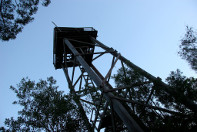
The Mt Borumba circuit. A golden oldie. Just like some of the nine  of us who lined up for this enjoyable ramble through the Imbil State Forest in South East Queensland to the fire tower on Mt Borumba. The 11 kilometre circuit, mainly on forestry tracks in the Yabba and Borumba logging areas, starts with a steepish climb. Then it wends its way gently uphill for another three and a half kilometres, first through park-like open Eucalypt forest and as it climbs towards the summit, it enters the cool shade of mature rainforest. The summit is topped by a decidedly rickety wooden structure known as the No.8 Fire Tower, now ringed with security fencing. The return trip, mostly downhill, features a gravelly descent and then a soggy track out to cattle yards.

Mt Borumba Cross section Blog image

Meanwhile back at the start of the walk our little band had formed up, my good bushwalking mate Brian Manuel in the lead. A quick vault over the locked gate and then up the dozer line that climbs vertically for The Beacon at 423 metres, an altitude gain of nearly 300 metres in one and a half kilometres. This must have been one intrepid dozer driver, no pussy footing around with zigzags, contouring or switch backs. Just straight up. And as I tottered my way up, one of those pesky elderly hares bounded by, calling out: “A good heart starter, hey”. No doubt about that. Fortunately for me, Brian called time, a welcome smoko break on the summit of The Beacon. A grassy glade shaded by gnarly old bloodwoods, a cooling breeze, fantastic views and a good feed.

On a crisp autumn day like this we had extensive views over Lake Borumba and the Yabba Creek catchment to the west. To the east and south were the high rugged hills and deep valleys of state forests, a verdant patchwork of rainforest, wet and dry sclerophyll forest, and plantations of hoop and bunya pine. These hills, now little more than 400 metres elevation, are the remnants of an ancient mountain chain planed down to a dissected plateau. The hard metamorphosed sediments, the Amamoor Beds, have resisted erosion, thus forming the elevated ridgelines that we were now following. Forestry areas are always full of places with tantalising names and intriguing stories to match.  Names like Breakneck Road, Derrier, Little Derrier, Tragedy, Buffalo and Gigher. One of my favourites was on a faded little sign outside Imbil which said: “The Foreign Legion.”  Not as in French Foreign Legion but an encampment of 150 displaced persons from World War Two.  Known generically as “The Balts”, they came mainly from Eastern Europe, few speaking English, and were allocated plantation work at one of three camps: Sterlings Crossing, Derrier and Araucaria.  The Balts lived a hard life in tent camps without electricity and running water. The children had a different take on any perceptions about hardship: “It was the best years of my life. We kids were allowed to run riot through the bush…It was simply fantastic.”

After The Beacon, we briefly took to a cattle pad before dropping down onto the Beacon Road. The route now meandered along forested ridgelines at about 400 metres, winding inexorably upwards towards Mt Borumba. Through gaps in the trees we caught occasional glimpses of the Borumba tower which was number 8 in a network of more than 30 fire towers spread across South East Queensland’s forestry areas. This 20 metre, three storey tower and its neighbours No.5 Mt Allan, and No.12 Coonoon Gibber, were used to fix the location of fires by triangulation. Interestingly, a large number of these fire towers were built by a Sunshine Coast resident Arthur Leis, all in days before fancy construction gear. Some of the higher towers like Jimna (47 metres) took Arthur three years to construct. No. 8 is a four -legged tower built in 1958, but variations included a three-legged tripod and the cheapskate model with boards nailed to a tree trunk. You can read more about Queensland’s fire towers in Peter Holzworth’s: Silent Sentinels: the story of Queensland’s Fire Towers.

No.8 Firetower. Mt Borumba

It was not long before we swung south onto the No 8 Tower Road, as did a battered old 4WD ute, which caused a ripple of expectation among those of us plodding along in the rear. I recalled with deep fondness bygone days when said ute would grind to a halt and its driver, fag glued to bottom lip, would beckon walkers over: “Everything OK?”.  A longish chat about the weather, cattle prices or his bee hives, and then our Good Samaritan would say: “Wanna lift?”  This was the signal for us to pile in. But our latter day 4WDer merely glided past, stopping occasionally to nail up ever more  Horses Ahead signs in preparation for an Easter horse endurance ride.

At the intersection with Borumba Mountain Road we swung west and climbed the final kilometre to the summit. As a veteran of Brian’s many forays into peak bagging I knew not to get overly excited about the possibility of majestic views over golden plains extended. And so it was. A view obscured not by the usual wreaths of claggy mist nor by sheets of bucketing rain. Just a wall of trees. Still it was a thoroughly pleasant spot for a lunch break: plenty of shade, grass to stretch out on and time to cast a covetous eye over one of Kiwi Ross’s mouth watering lunches. Take a chunk of crusty bread, add layers of rich red sliced tomatoes and then haystack the top with several acres of fresh alfafa sprouts. Joe to Kiwi Ross who was just about to sink in the tooth: “Hey, Ross. Would you like me to run the mower over that lot before you eat it?”

Lunch time on Borumba

 The inbound trip involved some backtracking for two kilometres until Brian suddenly executed a sharp left, and then plunged down an ever steepening trail mantled with loose gravel. Marbles on tiles.  Believe it or not, the best strategy is to jog down, skating over the top of the rolling gravel, just like those flocking sheep on NZ high country sheep runs. Michelle, Brian and Kiwi Ross, who are skilled exponents of this arcane ovine art, arrived first, fully intact. For the rest of us it was a matter of gingerly picking our way down, unfortunately not without mishap to a derrière or two. And then came the trudge along a sodden track before fetching up at the cattle yards. Leaving plenty time to scrape off the mud and head off for cold beer, coke or water at the Railway Hotel, Imbil. My thanks to Brian (leader), and fellow Borumbians Alf, Joe, Ross, Linda, Michelle, Robyn and Samantha.